
Local recreation area Hürtherberg


The local recreation area Hürtherberg emerged from the former lignite mine of the same name in the Rhenish lignite mining area in the Cologne Bay , southwest of Cologne . It is located on the eastern edge of the Hürth district of Alt-Hürth in the Rhein-Erft district . Large parts of the site, around 46.5 hectares , have been designated as the Hürther Berg landscape protection area since 1990 .
history
Dasbach and Warsch
As early as the 1920s, Adolf Dasbach , director of the former mining law union Hürtherberg, was the first to start afforestation of the mining areas in the Hürth area that had been charred under his leadership. Without any legal compulsion, he took measures for recultivation . Wherever the desolate landscape lay fallow, topsoil was raised and gardens or farmland created. In order to restore the balance of nature in his native region, Dasbach also had large areas of forest laid out. This with locust trees , houses , pine trees , red oaks and larches stood planted areas, which are often small or large residual lakes, formed as the foundation of today's of mixed forest -covered recreation areas .
A “law for overall planning in the Rhenish lignite mining district”, for which Wilhelm Warsch , District President of Cologne (1947–1957) had successfully campaigned for several years, came into force in 1950. The law now also regulates the measures to be taken for recultivation for the Cologne lignite mining district .
Huertherberg
The Hürtherberg area, which is now a recreational area, is also made up of a sizeable mixed forest, which is criss-crossed by well-tended, partially paved paths. The designation “local recreation area” was chosen by the responsible authorities in Hürth at the end of the 1970s. The expansion of the network of hiking trails and extensive reforestation work took place in 1980–1982. The forest paths lead visitors to the site to some sights.

Memory of Adolf Dasbach

Forest nature trail

Lookout point, distant view into the Bergisches Land


Roman finds

If you enter the site from its highest point (city bus station line 713) on Luxemburger and Kendenicher Straße, you are also on the historic route of the old Roman road Trier-Cologne . During the dismantling of the old Luxemburger Straße in 1959, Roman coins and a number of clay jugs of the same origin were found by the workers here by Adolf Dasbach. Below this site , the city of Hürth is reminding of the region's Roman past as part of the Regionale 2010 through the Mediterranean-style distribution circle established in the course of a new road confluence . This created a connection between the “local recreation area Hürtherberg”, which begins within sight, and the Römerstraße Cologne – Trier adventure space project .
Adolf Dasbach Way
In contrast to the sloping Luxemburger Straße, which runs roughly parallel to the south, Adolf-Dasbach-Weg , which remains at its level , only passes some (four) built-up lots at the beginning. One of them is the idyllically located youth hostel (also called Naturfreundehaus ), which celebrated its 60th anniversary in 2009. A little later, after the secluded, fenced-in urban drinking water system, the paved path becomes a forest path. Information boards set up along the wayside upgrade the walking paths as educational forest trails .
The path changes its course to the east at the high viewpoint near Trierer Straße. On a clear day, there is a distant view over the Cologne Bay to the heights of the Bergisches Land .

Sleepers of the mine railway in new use

Chains and rails of the old chain railway

The ravine to Trierer Straße becomes the "Klüttenweg" as an extension.


The path then leads over laid-out gradations, in which the incised slope area is supported with the wooden sleepers of the old mine railway route, to the valley floor of the site.


Trierer Straße was and is tunneled under here like a tube . In the past, this tube was used to move the charcoal trucks pulled by a chain conveyor, which were able to transport their goods without interruption between the opencast mine and the briquette factory . The extension of the ravine leads to the location of the former briquette factory. After the mine was closed , the factory with its two mighty chimneys was blown up in 1961. Remnants can still be seen in the area. A small street there bears the name "Klüttenweg" today - in the Rhineland briquettes are known as " Klütten ".
The area beyond Trierer Straße also belongs to the Hürther Berg area . Only it is less designed as a recreational area. In some cases development was allowed (including the Klüttenweg), and in some cases the paths get lost in the undergrowth (ravine). In any case, the area up to the Duffesbach was used as a dump for the overburden of the pit. The steep slopes were then planted for fortification. Trierer Strasse was only preserved in this mine area because a coal cable car ran parallel to it, which brought coal from the Engelbert mine near Berrenrath to the Ribbert briquette factory on Bonnstrasse, which existed before the Hürtherberg mine was opened (until the factory was destroyed in November 1944). A base plate (from mast No. 21) is still visible under the starling box at the bend in Trier Street. The train went straight from there (see discussion).
A level gravel path begins uphill from Trierer Straße in a westerly direction that leads to Adolf-Dasbach-Weiher .
Adolf-Dasbach-Weiher
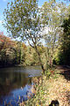
On May 25, 1906, the Peter Werhahn company started the industrial development of a lignite mine on Hürther Berg and founded the Hürtherberg trade union for this purpose. The pit had previously been operated in a rural manner by the Hürth landlord Wolfen and the last owners of the Hürth castle, the Clouth and Ritter families. On the site of the Hürtherberg opencast mine northwest of Luxemburger Straße, also known as the “old opencast mine”, a long, narrow body of water was later created . Today it bears the name of the mine director Adolf Dasbach, who headed the “Hürtherberg Union” from 1919. The pond, which is surrounded by heaped overburden dumps on its east side, is centrally located in what is now the “local recreation area Hürtherberg”, which is considered one of the first recultivated areas in the region. The water is fed from a small spring on the rising western edge, as well as from groundwater and rainwater. The Adolf-Dasbach-Weiher, also called Dasbachweiher, was built around 1925 and has an approximate size of 1 ha and a depth of 4.8 meters. Its currently slightly "kinked" shape is probably the result of earth movements in the non-grown soil of the southern slope, which is supposed to be more straightforward on old cadastral drawings. It belongs to the group of biotopes in the Rhein-Erft district according to §62 of the law for safeguarding the natural balance and for the development of the landscape (in short: the landscape law NRW)

To the west
Eastward

Eastern end area
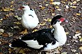
Waterfowl


The pond is like the waters of the other in Ville area lying Ville Lakes a nutrient-poorer, calcareous pond. It is populated with candelabrum algae (Characeae) and reeds at its end areas in the west and east . Like the surrounding waters, it is of great importance as a habitat for numerous migrating and sometimes breeding water birds and other aquatic animals. The pond is only provided with a path on its south side, on the east and west side it is covered with dense reeds. On its entire north side, a steep slope extends to the water surface.
Facilities
Playing, grilling

On the west side of the pond, after a slight ascent, you come to a large children's playground . On a well-tended lawn there are tables and benches made of solid wood, a swing and a climbing house.
To the north of the playground, an uphill path leads to a roofed barbecue area for safe barbecuing . From here or from Trierer Straße at the end of the village you can get to the memorial.
Hochkreuz

Above the village, on the outer northern slope of the area, a mighty war memorial was erected in a forest clearing and inaugurated on October 1, 1955. It was created by the planning and execution company Hertel from Cologne. The 7.60 m high cross and the semicircular inscription panels are made of shell limestone , the surrounding wall and the paving made of Oberbergic gray wacke . The memorial has been entered in the list of monuments as an architectural monument since 1997 .
The Hochkreuz, which can also be clearly seen from the village, is a memorial for those who fell in the world wars.
See also
- List of landscape protection areas in the Rhein-Erft district (including LSG Hürther Berg)
Web links
- Information from Stadtwerke Hürthl
- Friends of Nature House and Youth Hostel Hürth - Villehaus. TV Die Naturfreunde, OG Kendenich eV, accessed on July 27, 2010 .
- Youth hostel Huerth Villehaus. German Youth Hostel Association, Main Association, accessed on July 27, 2010 .
literature
- Clemens Klug: Hürth - how it was, how it was. Steimel Verlag, Cologne undated (1962)
- Clemens Klug: Hürth - art treasures and monuments. Huerth 1978
Individual evidence
- ↑ World Database on Protected Areas - LSG Hürther Berg (English)
- ↑ Clemens Klug: Hürth - as it was, as it was. P. 251 f.
- ↑ According to a written communication from the city (mail of October 17, 2008)
- ↑ Clemens Klug: Hürth - as it was, as it was. P. 32 f.
- ↑ Hans Desery: Open-cast lignite mining on Hürther Berg , in Hürther Heimat, Vol. 73, pp. 64–96.
- ↑ Biotopes in the Rhein-Erft district ( Memento of the original from September 24, 2015 in the Internet Archive ) Info: The archive link was automatically inserted and not yet checked. Please check the original and archive link according to the instructions and then remove this notice. rhein-erft-kreis.de
- ↑ Dasbachweiher naturpark-rheinland.de
- ↑ §62 Biotopes in the Rhein-Erft District ( Memento of the original from January 7, 2014 in the Internet Archive ) Info: The archive link was automatically inserted and not yet checked. Please check the original and archive link according to the instructions and then remove this notice. rhein-erft-kreis.de
- ↑ Flora-fauna-habitat areas and bird sanctuaries. (No longer available online.) Rhein-Erft-Kreis, Der Landrat, archived from the original on March 9, 2012 ; Retrieved on July 27, 2010 : “Ville-Seenkette, Habitat: low-nutrient (oligo- to mesotrophic) calcareous still waters, species: Characeae turf (chandelier algae)" Info: The archive link was automatically inserted and not yet checked. Please check the original and archive link according to the instructions and then remove this notice.
- ↑ According to a written communication from the city (mail of October 17, 2008 Department of Monument Protection) with reference to Hürth - Art Treasures and Monuments by Clemens Klug

![]() Active:
Garzweiler |
Hambach |
In the
Active:
Garzweiler |
Hambach |
In the
![]() Closed:
Alfred |
Mountain Spirit |
Bergheim |
Berrenrath |
Concordia |
Donatus |
Düren |
Fortuna-Garsdorf |
Cheeky |
Gruhlwerk |
Hürtherberg |
Liblar |
Roddergrube |
Neurath |
United Ville |
Future |
Zülpich
Closed:
Alfred |
Mountain Spirit |
Bergheim |
Berrenrath |
Concordia |
Donatus |
Düren |
Fortuna-Garsdorf |
Cheeky |
Gruhlwerk |
Hürtherberg |
Liblar |
Roddergrube |
Neurath |
United Ville |
Future |
Zülpich
Coordinates: 50 ° 52 ′ 7 ″ N , 6 ° 52 ′ 28 ″ E