Hakenberg (Lichtenau)
|
Hook mountain
City of Lichtenau
Coordinates: 51 ° 38 ′ 25 ″ N , 8 ° 56 ′ 28 ″ E
|
|
|---|---|
| Height : | 363 m above sea level NN |
| Area : | 8.06 km² |
| Residents : | 227 (March 31, 2007) |
| Population density : | 28 inhabitants / km² |
| Incorporation : | 1st January 1975 |
| Postal code : | 33165 |
| Area code : | 05295 |
|
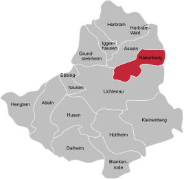
Location of Hakenberg in Lichtenau
|
|
Hakenberg is a northeastern village of Lichtenau in North Rhine-Westphalia , Germany and belongs to the Paderborn district . Hook mountain is also part of the Bürener Land region .
The old postcode of Hakenberg is 4791.
geography
Geographical location
The village has a pronounced hillside location on the eastern Paderborn plateau .
Neighboring places
The south and west of Hakenberg are bounded by the Lichtenau district of Lichtenau and the north by the Lichtenau district of Asseln . The eastern boundary of the town is at the same time the Lichtenau city boundary and the district boundary against the Höxter district . Here in the north the Bad Driburg district of Neuenheerse and in the south the core town of Willebadessen border on Hakenberg .
climate
Like Ostwestfalen-Lippe, Hakenberg belongs to the oceanic climatic area of northwest Germany , to which it owes its low temperature contrasts and mild winters. However, continental influences are already at work . The temperature in summer is higher and the nights are cooler than in closer proximity to the coast. The location on the edge of the Egge Mountains causes a submontane climate of the low mountain range with cooler temperatures and higher precipitation than in other locations in the district.
history
The establishment of a settlement in the Soratfeld southeast of Paderborn was rare in the Middle Ages. The settlement was originally called Havixburg, which suggests a previous fortification. However, there is no evidence of a castle in the sources or archaeologically. The place probably had a special relationship with the nearby Kerkdorp, which was deserted in the Middle Ages . So the still existing cemetery of the lost place was used. Hook mountain belongs to the parish of Lichtenau and has its own chapel, the St. Antonius Chapel .
Since its foundation, the settlement has belonged to the territory of the Princes' Diocese of Paderborn ( Hochstift ) in the Holy Roman Empire , which was formed in the 14th century , and from the 16th century to the Lower Rhine-Westphalian Empire . In 1802/03 the bishopric was occupied by the Kingdom of Prussia . In Napoleonic times the place was part of the Kingdom of Westphalia . Since 1815, Hakenberg finally belonged to the Kingdom of Prussia, from 1871 it was part of the German Empire . 1945–1949 Hakenberg was part of the British zone of occupation , from 1946 state-ruled by the state of North Rhine-Westphalia and from 1949 also by the Federal Republic of Germany.
Incorporation
Before 1 January 1975, the former municipality of Hook Mountain belonged to the Office Lichtenau (Westfalen) in county Buren . With the entry into force of the Sauerland / Paderborn law , most of the municipalities of the Atteln office will be merged with the municipalities of the Lichtenau office and thus also Hakenberg to form the new city of Lichtenau (Westphalia) and will become part of the Paderborn district.
The legal successor to the dissolved office of Lichtenau and the municipality of Hakenberg is the city of Lichtenau.
politics
The mayor of Hakenberg is Andreas Rehermann.
See also
literature
- Helmut Winzen: Hakenberg . In: Josef Drewes (Ed.): The Hochstift Paderborn: Portrait of a region . 2nd Edition. Paderborn 1997, p. 138-139 .
Web links
- lichtenau-hakenberg.de
- Information about Hakenberg at lichtenau.de
- Hakenberg (Lichtenau) in the Westphalia Culture Atlas
Individual evidence
- ^ Geographical Commission for Westphalia (ed.): Geographisch-Landeskundlicher Atlas von Westfalen, Topic X Administration and Management, double sheet state and municipal administrative structure , Münster 1990. Cf. Gerhard Henkel : History and Geography of the Büren District. Paderborn 1974, p. 101 f and attached map.
- ^ Gerhard Henkel : History and geography of the Büren district. Paderborn 1974, p. 24 ff.
- ^ Federal Statistical Office (ed.): Historical municipality directory for the Federal Republic of Germany. Name, border and key number changes in municipalities, counties and administrative districts from May 27, 1970 to December 31, 1982 . W. Kohlhammer, Stuttgart / Mainz 1983, ISBN 3-17-003263-1 , p. 320 f .


