
Kalktrifte Willebadessen
|
Kalktrifte Willebadessen
|
||
.jpg) Butterfly trail in the limestone drifts |
||
| location | Willebadessen , Höxter district , North Rhine-Westphalia , Germany | |
| surface | 112 ha | |
| Identifier | HX-069 | |
| WDPA ID | 318624 | |
| Natura 2000 ID | DE-4320-303 | |
| FFH area | 46 ha | |
| Geographical location | 51 ° 38 ' N , 9 ° 3' E | |
|
||
| Setup date | 2003 | |
| administration | Lower landscape authority of the Höxter district | |

.jpeg)
The Kalktriften of Willebadessen are a protected area in Willebadessen in Höxter that the continuation of the by grazing sheep and goats caused Kalkhalbtrockenrasens secures. Outstanding features are the occurrence of over 50 butterfly species , especially the very rare cross gentian ant blue , as well as the occurrence of endangered gentian and orchid species . The area is made accessible to tourists through the "Butterfly Trail" , an adventure trail 3.5 km in length.
The nature reserve of 112 ha has the identifier HX-069 and includes the FFH area DE-4320-303 of 46 ha.
Butterfly path

The butterfly path , which is under the motto “With the flapping of the wings of the blue” , leads along the limestone stretches . This adventure trail is also a 3.5 km long section of the Hitgenheierweg , a circular hiking trail around Willebadessen. The character of the path is reminiscent of an alpine high alpine pasture with its gentian-rich limestone lawn and its wide, always open view of the Nethetal and the Egge Mountains opposite . Along the way, 8 information boards provide visitors with knowledge about the ecological relationships between the traditional use of the area as a sheep pasture, the biodiversity and the livelihood of many rare butterfly species. Special lounger benches invite you to relax at sunny vantage points. The theme of the butterfly path is also taken up by some artistic works, such as the mosaic of a bluebell. The butterfly trail was opened on July 10, 2010.
Directions
The butterfly path begins on the Nethe at the eastern exit of Willebadessen, where the K 19 crosses the L 763 (Fölsener Straße). A parking lot for hikers is available. It is a good 2 km from Willebadessen train station . For train drivers, it is advisable to walk the entire Hitgenheierweg, because this circular route can be started and ended directly at the train station.
Origin of name
The term Trift comes from Middle High German and is related to the High German term drift . He names a hat , an area where the cattle were tended. The prefix lime names the rock here.
geography
The limestone drifts of Willebadessen are located northeast of the city, naturally in the Oberwälder Land . The Nethe flows from its source in Neuenheerse to Willebadessen eastwards along the Eggegebirge in a south-southeast direction and bends completely to the east at the height of Willebadessen. The pastures are on the steep, eastern slopes of the Nethetal, opposite the Egge Mountains. To the south they reach to where the Nehte bends to the east. They are predominantly oriented west-southwest.
At the southern end a distinctive, steep mountain ridge, which has an inverted V-shape in profile, leads down into the Nethetal. Here the drifts reach their maximum dryness. The character of this ridge is almost Mediterranean with its steepness, rockiness, dryness and sun exposure. The butterfly path begins here on the Nethe and leads on the back of this ridge up into the Trift.
geology

rock
The Nethetal cuts through the Brakeler Muschelkalkschwelle . Accordingly, there is shell limestone on the limestone drifts of Willebadessen .
water
The karst, water-permeable rock, in combination with the south-west orientation of the terrain and its steepness, causes its particular dryness.
ground
The originally forested steep slopes are covered with nutrient-rich, humus-rich, but stony rendzines . Their shallowness was increased in the course of time by deforestation , grazing, the step of animals and the associated soil erosion .
history
Because of their steepness, rockiness and dryness, these slopes of the Nethe were never suitable for farming or for hay meadows. That is why they were used by the residents of Willebadessen as pastures for sheep and goats. Originally forested, they developed into hat willows over time . In contrast to sheep, trees are bitten much more severely by goats. According to citizens of Willebadess, the slopes were used as pastures for sheep and goats until the late 1950s and were so poorly overgrown with bushes that you could see every white goat from afar. Since then these pastures have fallen fallow, covered with bushes or have been reforested. These changes lasted until 2000. The open spaces became smaller, grassy, hedges spread and the paths grew over. The area was barely accessible.
Since the year 2000, a total of 45 hectares have been purchased with the help of the North Rhine-Westphalia Foundation for Nature Conservation, Homeland and Cultural Preservation. The remaining areas are owned by the city of Willebadessen and have been made available by them. Since then, the areas have been gradually cleared of bushes and the exposed areas of the limestone drifts are grazed with sheep again. The de-bushing was financially supported by the EU, the Detmold district government and the Höxter district as well as a compensatory measure for the construction of the harrow crossing of the ICE-Paderborn – Kassel line by Deutsche Bahn.
ecology
Culture-related poor grassland due to erosion, nutrient displacement and browsing selection
The area is a poor grassland , more precisely a semi-arid grassland and the yield of the meadows is not completely meager. The originally nutrient-rich rendzinen and high amounts of precipitation on the Egge Mountains contrasts with the karst nature of the area, which together with its south-west orientation of the hillside quickly leads to a withering of the pastures during dry periods. But it is above all the steepness of the originally forested slopes that justified its use as a hat. The flatter areas in the ridge above the Nethetal, on the other hand, are used as grain fields. Only this grazing with sheep and goats, the step and selective browsing of the animals led to the typical fauna and flora that characterize a semi-arid lawn.
Deforestation and the breaking of the sod by cattle stairs lead of the soil on the steep slopes to increased erosion. This became shallower. As a result, its ability to store moisture continued to decline. Occasional dry periods have had more serious consequences. In general, it was also customary to pens the animals they guarded at night to dump in fields to be fertilized. In this way, nutrients were obtained from the extensively used pastures and relocated to the intensively used fields. But it was only in combination with the selective browsing by the grazing animals, which among other things let the bitter gentians and the prickly thistles stand, that the flowery grassland emerged, which is a preferred biotope for the butterflies. A biotope was created through cultural influence, which provides a refuge for rare animals and plants that have lost their habitat in other locations due to the intensification of agriculture and other cultural influences.
Protection goals
The following protection goals were defined as part of Natura 2000 :
- Preservation and development of typical orchid-rich, short-grass, gaps to closed semi-arid limestone lawns in combination with thermophilic fringes and bushes and poor pastures
- Conservation and promotion of poor grassland
- Securing and developing hedge structures, designing shrubbery and hedge strips as near-natural forest edge biotopes
The following measures are proposed for this purpose:
- Networking of the isolated areas, if possible using sheepskins
- if necessary, removal of bushes and prohibition of afforestation
- Avoidance of damage caused by being stepped on, possibly steering of leisure activities
- Maintaining / introducing extensive grazing without fertilization
- Avoidance of eutrophic influences, if necessary establishment of buffer zones
In the scientific background there are special goals for the preservation of butterfly biotopes, which were summarized by Lechner in 1997 as follows:
- Zoning with a lower and upper edge of bushes.
- Small zoning with transitions from scree-rich, vegetation-poor areas over legume cushions to taller grasses and perennials.
- Preservation of special small habitats, e.g. B. heaps of stones, small rock fragments, single trees, bushes with sun and shade areas.
- Preservation of the special climatic conditions by preventing a cold air build-up, by preventing a thick layer of heat-insulating plants, by creating surfaces with different temperatures and by rows or groups of hedges across the main wind direction.
- Larger stocks of caterpillar forage plants, larger stocks of nectar plants.
- Preservation of pupation places; Creation of the most favorable wood distribution (about 10% to 15% of the area, importance as forage plants and as a source of shade).
- Preservation or creation of a supply of natural plants in the surrounding area (e.g. thistle stands in fields and roadsides; herbicide-free marginal strips rich in flowering plants in fields).
biology
Among other things, as part of Natura 2000, important species of fauna and flora were surveyed.
(The thumbnails that represent the individual value-determining species were taken in different locations.)
plants
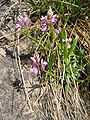
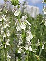
- plants

Common cat paw ( Antennaria dioica )

Common anthyllis ( anthyllis vulneraria )

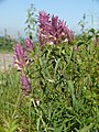
Cross gentian ( gentiana cruciata )

German fringed gentian ( Gentianella germanica )

Mosquito Haendelwurz ( Gymnadenia conopsea )

Large two-leaf ( Listera ovata )
Field quail wheat ( Melampyrum arvense )

Bee ragwort ( Ophrys apifera )

Fly Ragwort ( Ophrys insectifera )

Male orchid ( Orchis mascula )

Greenish forest hyacinth ( Platanthera chlorantha)
Bitter finial ( Polygala amara )
Upright ziest ( Stachys recta )

Mountain clover ( Trifolium montanum )


Animals
- Butterflies
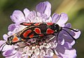
Esparsette Ram or Carniolan Ram ( Zygaena carniolica ) alias (Agrumenia carniolica)
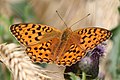
Fiery mother-of-pearl butterfly ( Argynnis adippe )

Imperial coat ( Argynnis paphia )

Fairy bear ( Callimorpha dominula )
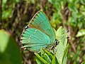
Green hairstreak ( Callophrys rubi )
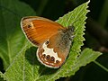
White-banded meadow bird or pearl grass butterfly ( Coenonympha arcania )

Horseshoe clover or southern hay butterfly ( Colias alfacariensis )

Dwarf blue ( Cupido minimus )

Kronwicken-Dickkopfffalter ( Erynnis day )

Comma thick-headed butterfly ( Hesperia comma )

Silver-green blue ( Polyommatus coridon ) alias (Lysandra coridon)

Presumably speedwell piebald ( Melitaea aurelia )

Thyme ram ( Zygaena purpuralis ) alias (Mesembrynus purpuralis)

Great mother-of-pearl butterfly ( Argynnis aglaja ) alias (Mesoacidalia aglaja)
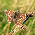
Small cube-headed butterfly or mallow cube-shaped spot ( Pyrgus malvae )

Little pentagonal ram ( Zygaena viciae )


.jpg)
.JPG)

_2_(HS).jpg)

.jpg)


- Other animals

Breeding ground of the red killer ( Lanius collurio )

Partridge ( Perdix perdix )

Smooth snake ( Coronella austriaca )

Sand lizard ( Lacerta agilis )

Short-winged bite insect ( Metrioptera brachyptera )

Heather grasshopper ( Stenobothrus lineatus )

Long-feeler arachnid ( Tetrix tenuicornis ) alias (Tetrix nutans)

Common heather snail, also western heather snail ( Helicella itala )

.jpg)


Web links
- Nature reserve "Kalktriften Willebadessen" in the specialist information system of the State Office for Nature, Environment and Consumer Protection in North Rhine-Westphalia
- Kalktriften Willebadessen (Flyer as PDF; 674 kB) ( Memento from May 31, 2014 in the Internet Archive )
- www.nrw-stiftung.de: A short film about the work of the biological landscape stations u. a. with gentian and limestone stripes
- www.erlesene-natur.de: Kalktriften Willebadessen - butterfly path
- www.nrw-stiftung.de: Kalktriften at Willebadessen - From Sheep to Butterfly
- www.ruengener.eu: Three information boards and many excellent pictures
- www.egge-weser-digital.de:Kalktrockenrasen, Kalkhalbtrockenrasen and closely related grassland communities
- Kalktrifte near Willebadessen in the Höxter district. Youtube video of the NRW Foundation for Nature Conservation, Heritage and Cultural Preservation , 3:34 min, accessed on March 26, 2020.
Individual evidence
- ↑ a b c d e f g egge-weser.de
- ↑ geodienste.bfn.de
- ↑ a b kreis-hoexter.de, flyers ( Memento of 31 May 2014 Internet Archive )
- ↑ naturschutz-fachinformationssysteme-nrw.de
- ↑ kreis-hoexter.de ( Memento of the original from May 31, 2014 in the Internet Archive ) Info: The archive link was inserted automatically and has not yet been checked. Please check the original and archive link according to the instructions and then remove this notice.
- ↑ Landschaftsstation.de
- ↑ openstreetmap.org
- ↑ verkehrsverein-willebadessen.de
- ↑ duden.de
- ↑ egge-weser-digital.de
- ↑ Geoscientific community descriptions NRW ( Memento from May 31, 2014 in the Internet Archive )
- ↑ a b c d e f egge-weser-digital.de
- ↑ a b egge-weser-digital.de
- ↑ a b c d e f g h i j naturschutz-fachinformationssysteme-nrw.de ( Memento of the original dated May 31, 2014 in the Internet Archive ) Info: The archive link was inserted automatically and has not yet been checked. Please check the original and archive link according to the instructions and then remove this notice.
- ↑ a b c d e f g h i j k l m n o p q r s t u v w x y z aa ab ac ad ae af ag ah ai aj ak al naturschutz-fachinformationssysteme-nrw.de

Albaxer Trift | Asseler Forest | On the Berenbruch | On the Eschenberg | Baumerstal | Bielenberg | Bleikuhlen and Waschebachtal | Bramberg | Beech forests between Mühlenberg and Hasselburg | Beech forests between Wildburg and Heineberg | Beech forests between Ziegenberg and Langer Berg | Desenberg | Drachenholl-Diemelaue | Egge-Nord (HX) | Emmeroberlauf and Beberbach | Finkenbruch | Gaffelntal and Kiepenberg | Goldberg | Gradberg | Groundless - Taubenborn | Hammerbachtal | Hanover cliffs | Heinenwiese | Hellberg-Scheffelberg | Hinnenburger Forst with Emder Bachtal | Hirschstein | Hoppenberg | Iberg at Welda | Iburg-Aschenhütte | Lean lime grass near Calenberg and Dalheim | Lean lime lawn near Ossendorf | Lean lime grass near Ottbergen and Bruchhausen | Kalktrifte Willebadessen | Lapwing pond | Kiekenstein | Klingelbachtal | Cliffs and sea of rocks near Hardehausen | King's View | Körbecker Bruch | Crows Mountain | Krekeler Berg - southern slope | Kuhkamp | Lebersiek | Menner strainer | Nausenberg | Nethe | Nethes estuary | Nieheim clay pit | Pölinxer reason | Headwaters Bockskopf | Räuschenberg | Rösebecker Bruch | Rumberg | Samensberg | Satzer Moor | Schalkstal | Schnegelberg | Schwarzbachtal (HX) | Schwiemelkopf | Selsberg | Stahler Ufer | Stockberg | Tunnel on the Kassel-Altenbeken railway line | Southern autumn mountain | Ponds at Steinheimer Holz | Devil's Gorge | Teutonia cliffs and Teutonia | Tonenburg and Saum estuary | Lower Eggeltal | Wandelnsberg | Weldaer Berg | Welda Forest | Wenkenberg | Wiekämpe | Goat field