Karlshof (Hohenaltheim)
|
Karlshof
Community Hohenaltheim
Coordinates: 48 ° 47 ′ 2 " N , 10 ° 29 ′ 26" E
|
|
|---|---|
| Height : | 496 m above sea level NHN |
| Residents : | 3 (May 25 1987) |
| Postal code : | 86739 |
| Area code : | 09081 |
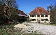
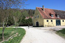
The Karlshof is a remote area of the municipality Hohenaltheim in the district of Donau-Ries in the district Lower Altheim . The former princely Wallerstein manor with the adjoining forester's house are registered architectural monuments .
geography
The Karlshof stands at the eastern end of the Kartäusertal , at the southern foot of the 537 m high Hochhauser Berg with the ruins of the Hochhaus Castle . Less than a kilometer to the west is the hamlet of Anhausen , which belongs to the municipality of Ederheim , and Niederaltheim is two and a half kilometers to the east.
history
Karlshof, formerly also Hinterhof or Schafhof, later called Albrechtshof, originally belonged to the rule of Hochhaus , then to the princes of Oettingen . After several changes of ownership, the Prince of Oettingen-Wallerstein bought the estate back in 1764 and had the facility repaired and expanded. In 1835, the prince had today's main building built with a hipped roof , and in 1856 the outbuilding with a gable roof . The two barns date from the 18th and 19th centuries.
From 1893 to 1982 the Karlshof was a large princely dominal property. The 90 hectare farm managed both fields and pastures. The livestock consisted of around 25 to 30 dairy cows, young cattle, poultry and their own sheep farm. At times the Karlshof operated its own brewery . The manor was primarily known for its inn. Already in the 1830s, the Karlshof was a popular excursion destination due to its idyllic location, which was valued for its festivities. For 1835, the economy is described as a place where the educated people of the area meet. For the population of Bollstadt , Ederheim , Forheim , Hohenaltheim, Hürnheim and Niederaltheim , business was the goal of the traditional Whitsun excursion . The economy flourished from 1916 to 1942. At that time, some hikers came from Nördlingen , and horse-drawn carriage rides were also taken to the Karlshof, which also had a bowling alley . Excursions to Karlshof were considered "something special", not everyday. The wasteland was also discovered as a summer retreat.
After the Second World War , the gastronomy in Karlshof experienced another boom. School and company outings were made to Karlshof and dance events were also held there. The workers of all princely domains in Nördlinger Ries held their harvest celebrations in Karlshof, in winter it was a meeting place for lumberjacks . But Karlshof was also a popular stop for hunting parties. In the 1960s, due to changes in leisure behavior and mobility, the decline of leisure culture in Karlshof began.
In 1983, the George Scouts of the Diocesan Association of Augsburg leased the manor and since then has operated it as the Karlshof scout center with a youth campground and playground. Youth groups, school classes and families could also use the sleeping spaces as self-catering. In the 1980s, the National Scouts Conference took place in Karlshof. The lease, which originally ran until 2013, was terminated in 2008 at the request of the Prince of Wallerstein-Oettingen.
In the course of the regional reform in Bavaria , Karlshof and the capital Niederaltheim came to Hohenaltheim on July 1, 1973.
Attractions
The forester's house and the manor house are protected architectural monuments .
The forester's house, a small building with a half-hipped roof, was built in 1911. In addition to the forester's house in Christgarten , it is the last remaining forest building of the former Princely Hohenaltheim Forestry Office and is now used as a residential building. It is the only permanently inhabited building in Karlshof. The Swabian Alb North Edge Path and other hiking trails of the Swabian Alb Association lead through Karlshof. The Main-Danube-Weg also runs through Karlshof. In 1903 the Karlshof was the starting point of the Nordrand-Weg and the 1904 marked Südrand-Weg to Tuttlingen . It was not until 1907 that the Nordrand-Weg and in 1910 the Südrand-Weg were extended to today's starting point at Donauwörth . To the east of the Karlshof stands a pedunculate oak marked as a natural monument with a trunk circumference of 4.53 m at a height of approx. 531 m.
literature
- Kathrin Schön: Historical cultural landscape in the Nördlinger Ries - data sheet for cultural landscape elements; Hohenaltheim community . Ed .: Bavarian State Office for the Environment . 2007, p. 12–14 ( digital copy [PDF]).
Web links
- Hohenaltheim community: Around Hohenaltheim
- Karlshof in the location database of the Bayerische Landesbibliothek Online . Bavarian State Library
Individual evidence
- ↑ Bavarian State Office for Statistics and Data Processing (Ed.): Official local directory for Bavaria, territorial status: May 25, 1987 . Issue 450 of the articles on Bavaria's statistics. Munich November 1991, DNB 94240937X , p. 399 ( digitized version ).
- ↑ Matthias Reiter, Uli Wagenpfeil: Karlshofabschied - An era comes to an end (= diocese of Augsburg [Ed.]: Idara 02 . No. 22 ). December 2008, p. 5–6 ( digital version (PDF; 11.6 MB) ).
- ^ Federal Statistical Office (ed.): Historical municipality directory for the Federal Republic of Germany. Name, border and key number changes in municipalities, counties and administrative districts from May 27, 1970 to December 31, 1982 . W. Kohlhammer GmbH, Stuttgart and Mainz 1983, ISBN 3-17-003263-1 , p. 792 .
- ^ "In the green forest ..." , in Augsburger Allgemeine from January 9, 2010, accessed on May 12, 2012
- ↑ Willi Siehler and Theo Müller: On the history of the north and south border lines of the Swabian Alb (HW 1 and 2) , in Blätter des Schwäbischer Albverein , No. 113/4, 2007, page 24
- ↑ Willi Siehler and Theo Müller: 100 Years of the Swabian Alb Nordrandweg (HW 1) , in Blätter des Schwäbische Albverein , No. 113/3, 2007, page 28
- ^ Pedunculate oak, OT Niederaltheim ( Memento from December 8, 2017 in the Internet Archive ) at www.naturdenkmale-donau-ries.de


