Krobia
| Krobia | ||
|---|---|---|

|
|
|
| Basic data | ||
| State : | Poland | |
| Voivodeship : | Greater Poland | |
| Powiat : | Gostyń | |
| Area : | 7.05 km² | |
| Geographic location : | 51 ° 47 ' N , 16 ° 59' E | |
| Height : | 117 m npm | |
| Residents : | 4325 (Jun. 30, 2019) |
|
| Postal code : | 63-840 | |
| Telephone code : | (+48) 65 | |
| License plate : | PGS | |
| Economy and Transport | ||
| Street : | Ext. 434 Gostyń - Rawicz | |
| Rail route : | Krotoszyn – Leszno | |
| Next international airport : | Poznan-Ławica | |
| Wroclaw | ||
| Gmina | ||
| Gminatype: | Urban and rural municipality | |
| Gmina structure: | 24 towns | |
| 22 school authorities | ||
| Surface: | 129.59 km² | |
| Residents: | 13,014 (Jun. 30, 2019) |
|
| Population density : | 100 inhabitants / km² | |
| Community number ( GUS ): | 3004033 | |
| Administration (as of 2009) | ||
| Mayor : | Sebastian Czwojda | |
| Address: | ul. Rynek 1 63-840 Krobia |
|
| Website : | www.krobia.pl | |
Krobia ([ ˈkrɔbja ]; German Kröben , older also Krebe ) is a city in the Polish Voivodeship of Greater Poland . It is the seat of a town and country municipality in the Powiat Gostyński .
Geographical location
The city is located in the historical region of Poznan , about 70 kilometers south of the city of Poznan .
history

The first mention of today's Krobia comes from the year 1258. At that time until 1796 the place was owned by the diocese of Poland . The place received city rights in the 13th century. During the second partition of Poland , the place came to Prussia in 1793 and was incorporated into the newly created province of South Prussia . In 1798 Kröben became a district town. In 1807 the city became part of the newly founded Duchy of Warsaw , but came back to Prussia in 1815 and became the seat of the Kröben district . In 1878 Kröben became part of the Gostyn district . At the beginning of the 20th century Kröben had a Protestant church, three Catholic churches, an archiepiscopal chapel, and a synagogue and was mostly inhabited by Poles .
After the First World War , Krobia became part of the newly established Poland . At the beginning of the Second World War , the place was occupied by the Wehrmacht in September 1939 . In 1945 the Red Army marched into the area.
Demographics
| year | population | Remarks |
|---|---|---|
| 1816 | 985 | according to other data 965 inhabitants, of which 935 Catholics, 30 Jews |
| 1821 | 1102 | |
| 1826 | 1300 | in 206 houses |
| 1837 | 1254 | |
| 1843 | 1365 | |
| 1858 | 1588 | |
| 1861 | 1681 | |
| 1867 | 1677 | on December 3rd |
| 1871 | 1596 | 50 Protestants, 1460 Catholics and 80 Jews (1450 Poles ); According to other data, 1596 inhabitants (on December 1), of which 57 were Protestants, 1462 Catholics, 77 Jews |
| 1885 | 1847 | including 91 Evangelicals and 77 Jews |
| 1900 | 2186 | mostly Polish and Catholic residents |
| 1910 | 2384 | on December 1st |
Number of inhabitants to date in graphical representation

Culture and sights
Buildings
Krobia's attractions include:
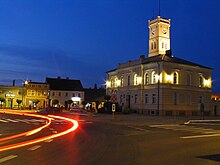
- the neo-romantic town hall, built in 1840
- the baroque parish church of St. Nicholas from the 18th century
- the Church of the Holy Spirit from the 18th century
- the Romanesque cemetery church of St. Egidius from the 13th century
local community
Krobia is the seat of the town and country municipality of the same name. This has about 13,000 inhabitants on an area of 129.59 km². The 22 Schulz Offices ( sołectwo ) are: Bukownica, Chumiętki, Chwałkowo, Ciołkowo, Domachowo, Gogolewo, Grabianowo, Karzec, Kuczyna, Kuczynka, Niepart, Pijanowice, Posadowo, Potarzyca, Przyborowo, Pudliszki , Rogowo, Stara Krobia, Sułkowice, Wymyslowo, Ziemlin and Żychlewo. There are also the villages of Dębina and Florynki.
Economy and Infrastructure
traffic
The Krobia station is located south of the city on the Łódź – Forst (Lausitz) railway line , and in the past it was also on the Gostyner Kreisbahn , which had a station closer to the city center.
Voivodeship Road 434 ( droga wojewódzka 434 ) runs through the city in a north-south direction . After about twelve kilometers it leads through Gostyń and crosses national road 12 . In a southerly direction, the 434 joins Landesstraße 36 after about 14 kilometers .
The nearest international airports are Poznan-Ławica Airport , about 65 kilometers north and Wroclaw Nicolaus Copernicus Airport , about 65 kilometers south of Krobia.
literature
- Heinrich Wuttke : City book of the country Posen. Codex diplomaticus: General history of the cities in the region of Poznan. Historical news from 149 individual cities . Leipzig 1864, pp. 342-343.
Web links
- City website (Polish)
Individual evidence
- ↑ a b population. Size and Structure by Territorial Division. As of June 30, 2019. Główny Urząd Statystyczny (GUS) (PDF files; 0.99 MiB), accessed December 24, 2019 .
- ↑ http://digitool.is.cuni.cz:1801/view/action/nmets.do?DOCCHOICE=1026926.xml&dvs=1468003412593~233&locale=de_DE&search_terms=&adjacency=&VIEWER_URL=/view/action/nLEmets.do ? . & 3 & divType = & COPYRIGHTS_DISPLAY_FILE = license_mapy
- ↑ a b c szukacz.pl, Krobia - Informacje dodatkowe , accessed on December 18, 2009
- ↑ a b Territorial.de, Gostingen district , accessed on December 18, 2009
- ↑ a b Meyer's Large Conversation Lexicon . 6th edition, Volume 11, Leipzig / Vienna 1907, p. 726 .
- ↑ Alexander August Mützell and Leopold Krug : New topographical-statistical-geographical dictionary of the Prussian state . Volume 3, Kr – O , Halle 1822, p. 17, item 5282 .
- ↑ a b Alexander August Mützell and Leopold Krug : New topographical-statistical-geographical dictionary of the Prussian state . Volume 5: T – Z , Halle 1823, pp. 312-319, item 342.
- ^ Leopold von Zedlitz-Neukirch : The state forces of the Prussian monarchy under Friedrich Wilhelm III . Volume 2, part 1, Berlin 1828, p. 97, item 10.
- ^ A b c d Heinrich Wuttke : City book of the country of Posen. Codex diplomaticus: General history of the cities in the region of Poznan. Historical news from 149 individual cities . Leipzig 1864, pp. 342-343.
- ^ A b Royal Statistical Office: The municipalities and manor districts of the Prussian state and their population. Edited and compiled from the original materials of the general census of December 1, 1871. Part IV: The Province of Posen , Berlin 1874, pp. 110–111, item 6 ( E-Copy, pp.117-118 ).
- ^ Gustav Neumann : The German Empire in geographical, statistical and topographical relation . Volume 2, GFO Müller, Berlin 1874, pp. 146-147, item 5 .
- ↑ M. Rademacher: German administrative history from the unification of the empire in 1871 to the reunification in 1990. (Online material for the dissertation, Osnabrück 2006)
- ↑ gemeindeververzeichnis.de
-
↑
For 1875 (1577), 1871 (1596): Słownik geograficzny Królestwa Polskiego, 1883, Volume IV, p. 675, Online
For 1885 (1847): Geschichte on demand, Landkreis Gostyn ( Memento of the original from December 31, 2009 on the Internet Archive ) Info: The archive link was inserted automatically and has not yet been checked. Please check the original and archive link according to the instructions and then remove this notice. , accessed on December 18, 2009 For 1900 (2186): Meyers Großes Konversations-Lexikon, Volume 11. Leipzig 1907, p. 726, online For June 30, 2009 (4099): "LUDNOŚĆ - STAN I STRUKTURA W PRZEKROJU TERYTORIALNYM" ( Memento from February 15, 2010 in the Internet Archive )


