
Rohrenfels
| coat of arms | Germany map | |
|---|---|---|

|
Coordinates: 48 ° 41 ' N , 11 ° 9' E |
|
| Basic data | ||
| State : | Bavaria | |
| Administrative region : | Upper Bavaria | |
| County : | Neuburg-Schrobenhausen | |
| Management Community : | Neuburg on the Danube | |
| Height : | 390 m above sea level NHN | |
| Area : | 17.54 km 2 | |
| Residents: | 1548 (Dec. 31, 2019) | |
| Population density : | 88 inhabitants per km 2 | |
| Postal code : | 86701 | |
| Area code : | 08431 | |
| License plate : | ND, SOB | |
| Community key : | 09 1 85 157 | |
| Community structure: | 10 parish parts | |
| Association administration address: | Neuhofstrasse D 228 86633 Neuburg adDonau |
|
| Website : | ||
| Mayoress : | Manuela Heckl ( village community ) | |
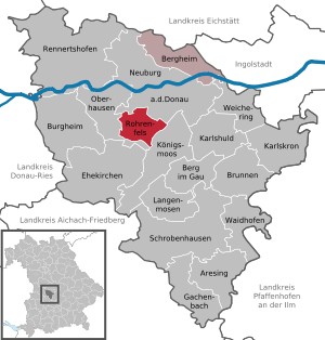
| Location of the municipality of Rohrenfels in the district of Neuburg-Schrobenhausen | ||
  |
||


Rohrenfels is a municipality in the Upper Bavarian district of Neuburg-Schrobenhausen and a member of the Neuburg an der Donau administrative association .
geography
location
Rohrenfels is located in the Ingolstadt planning region six kilometers south of Neuburg an der Donau .
Community structure
The municipality has 10 officially named parts of the municipality (the type of settlement is given in brackets ):
|
|
The three districts Ballersdorf, Rohrenfels and Wagenhofen exist .
Neighboring communities
history
Until the church is planted
The Rohrbach Church (later Rohrenfels) was first mentioned in 1214. Rohrenfels belonged to the former Duchy of Neuburg-Sulzbach and its court in Neuburg; since 1777 the area was part of the Electorate of Bavaria . Rohrenfels was Hofmarksitz , which was owned by the Taxis family from 1618 to 1832 . In the course of the administrative reforms in Bavaria , today's municipality was created with the municipal edict of 1818 .
Incorporations
On May 1, 1978, the previously independent communities Ballersdorf and Wagenhofen were incorporated.
Population development
Between 1988 and 2019 the municipality grew from 1,077 to 1,548 by 471 inhabitants or by 43.7%.
- 1961: 1002 inhabitants
- 1970: 984 inhabitants
- 1987: 1057 inhabitants
- 1991: 1278 inhabitants
- 1995: 1379 inhabitants
- 2000: 1373 inhabitants
- 2005: 1509 inhabitants
- 2010: 1512 inhabitants
- 2015: 1496 inhabitants
- 2016: 1532 inhabitants
- 2019: 1548 inhabitants
politics
Mayor is Wigbert Kramer (CSU) from 2014 to 2020. He is the successor to Karin Schäfer (Rohrenfels village community, 2002-2014) and Herbert Heckl (CSU, until 2002). Manuela Heckl (Rohrenfels village community) was elected as the new mayor in the 2020 local elections without competitors, with 87.8%; their term of office begins on May 1, 2020.
In the electoral period from 2014 to 2020, the parties and groups of voters are represented in the municipal council as follows:
- CSU: 5 seats
- Rohrenfels village community: 3 seats
- Free voters Wagenhofen-Ballersdorf: 4 seats
In the election period from 2020 to 2026, the three nominations each received four seats on the municipal council; these are:
- CSU
- Rohrenfels village community
- Free voters Wagenhofen-Ballersdorf
Architectural monuments
Economy and Infrastructure
Economy including agriculture and forestry
In 1998, according to official statistics, there were 238 people in the manufacturing sector and no employees in the trade and transport sector at the place of work. In other economic sectors, 23 people were employed at the place of work subject to social security contributions. There were a total of 485 employees at the place of residence subject to social security contributions. There were five companies in the manufacturing sector and two in the construction sector. In addition, in 1999 there were 57 farms with an agriculturally used area of 1255 ha, of which 928 ha were arable land and 327 ha were permanent green space.
education
The following institutions exist (as of 2009):
- Kindergarten "St. Elisabeth “, new building, completed in 2009, with 50 kindergarten and twelve crèche places. 44 children are looked after.
literature
- Rudolf Niessner: Chronicle of the community Rohrenfels - history of the localities Rohrenfels, Wagenhofen and Ballersdorf with their districts and hamlets Ergertshausen, Baiern . Rohrenfels community, 1989.
Web links
- Entry on the coat of arms of Rohrenfels in the database of the House of Bavarian History
- Community website
- Rohrenfels: Official statistics of the LfStat
- Rohrenfels in the location database of the Bavarian State Library Online . Bavarian State Library
Individual evidence
- ↑ "Data 2" sheet, Statistical Report A1200C 202041 Population of the municipalities, districts and administrative districts 1st quarter 2020 (population based on the 2011 census) ( help ).
- ^ Rohrenfels community in the local database of the Bavarian State Library Online . Bayerische Staatsbibliothek, accessed on September 12, 2019.
- ^ Federal Statistical Office (ed.): Historical municipality directory for the Federal Republic of Germany. Name, border and key number changes in municipalities, counties and administrative districts from May 27, 1970 to December 31, 1982 . W. Kohlhammer, Stuttgart / Mainz 1983, ISBN 3-17-003263-1 , p. 602 .
- ^ Rohrenfels parish. District Office Neuburg-Schrobenhausen, accessed on August 9, 2020 .
Ballersdorf | Rohrenfels with Baiern, Fesenmühle, Isenhofen and Krellesmühle | Wagenhofen with Doferhof, Ergertshausen and Neustetten