
Krosigk
|
Krosigk
Municipality Petersberg
|
|
|---|---|
 |
|
| Height : | 124 m |
| Area : | 9.02 km² |
| Residents : | 858 (March 7, 2019) |
| Population density : | 95 inhabitants / km² |
| Incorporation : | January 1, 2010 |
| Postal code : | 06193 |
| Area code : | 034603 |
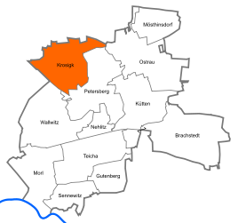 .svg) Location of Krosigk in Petersberg
|
|
Krosigk is a village in the municipality of Petersberg in the Saalekreis in Saxony-Anhalt (Germany). It consists of the districts Krosigk and Kaltenmark.
Until the formation of the unified community Petersberg on 1 January 2010 Krosigk was an independent municipality in the Götschetal-Petersberg with the corresponding district Kaltenmark and settlement New houses. The last mayor of Krosigk was Roland Sonne.
geography
Krosigk is located 15 km north of Halle (Saale) , at the foot of the Petersberg .
history
Krosigk was a Slavic foundation in the 7th century. In the 10th century there was a castle complex, which was one of the oldest stone castles in the region and is the ancestral home of the von Krosigk family . From 1451 to 1813, Krosigk Castle and a later manor house were owned by the von Trotha family .
The noble places Krosigk and Kaltenmark belonged to the hall circle of the Archbishopric of Magdeburg . With its annexation to Prussia, from 1680 they belonged to the Brandenburg-Prussian Duchy of Magdeburg .
With the Peace of Tilsit , Krosigk and Kaltenmark were incorporated into the Kingdom of Westphalia in 1807 and assigned to the Halle district in the Saale department. They belonged to the canton of Löbejün . After Napoleon's defeat and the end of the Kingdom of Westphalia, Napoleon's allied opponents liberated the Saalkreis in early October 1813. During the political reorganization after the Congress of Vienna in 1815, Krosigk and Kaltenmark were attached to the Merseburg administrative district of the Prussian province of Saxony in 1816 and assigned to the Saalkreis.
On July 1, 1950, the previously independent municipality of Kaltenmark was incorporated.
coat of arms
Blazon : "In silver, a black raven with a golden eye standing on a halved green mill wheel with five spokes, holding a golden ring in its beak." (Cf. Merseburg # The Merseburger Rabensage )

Culture and sights
museum
Heimatstube, which shows a historical outline of the community.
Buildings
- Krosigk Castle with a keep from the 9th century
- Fortified church (late Romanesque, around 1150, with tombstones of the von Trotha family)
- Watermill (16th / 17th century)
- Post mill (18th century)
- Krosigk pigeon tower
- Krosigk War Memorial
Transport links
Krosigk is on the connecting road from Halle (Saale) to Köthen . The federal motorway 14 , which leads from Leipzig to Magdeburg , is 5 km south of Krosigk.
Web links
Individual evidence
- ↑ StBA: Area changes from January 01 to December 31, 2010
- ↑ Britta Schulze-Thulin: Hiking Guide for Central Germany , Halle (Saale) 2005, p. 27.
- ↑ Mention of the place in the book "Geography for all Stands", p. 130
- ^ Description of the Saale Department
- ^ The hall circle in the municipality register 1900
- ↑ Britta Schulze-Thulin: Hiking Guide for Central Germany , Halle (Saale) 2005, p. 27.

Alums | Beidersee | Brachstedt | Roof crack | Swivel head | Drobitz | Frößnitz | Ferdinande Pit | Gutenberg | High | Kaltenmark | Krosigk | Kütten | Merkewitz | Möderau | Mösthinsdorf | Morl | Nehlitz | Ostrau | Petersberg | Sennewitz | Sylbitz | Teicha | Trebitz | Wallwitz | Werderthau | Westewitz | Wurp