Krzeszowice
| Krzeszowice | ||
|---|---|---|

|
|
|
| Basic data | ||
| State : | Poland | |
| Voivodeship : | Lesser Poland | |
| Powiat : | Krakowski | |
| Gmina : | Krzeszowice | |
| Area : | 16.92 km² | |
| Geographic location : | 50 ° 8 ′ N , 19 ° 38 ′ E | |
| Residents : | 10,084 (Dec. 31, 2016) | |
| Postal code : | 32-065 | |
| Telephone code : | (+48) 12 | |
| License plate : | KRA | |
| Economy and Transport | ||
| Street : | DK79 Krakow - Chrzanów | |
| Rail route : | Jaworzno Szczakowa – Krakow | |
| Next international airport : | Krakow-Balice | |
Krzeszowice is a city in the powiat Krakowski of the Lesser Poland Voivodeship in Poland . It is the seat of the town-and-country municipality of the same name with around 32,300 inhabitants. The city had the status of a state-recognized health resort.
Geographical location
Krzeszowice is located in south-eastern Poland, about 25 kilometers northwest of the city center of Krakow . The state border with Slovakia runs 60 kilometers south.
history
The first documentary mention of a settlement on the site of today's Krzeszowice took place in 1286 when the Krakow Bishop Paweł awarded the post of mayor to Fryczko Freton, the bailiff of Bytom in the village of Cressouicy . In 1555 the place became the property of Stanisław Tęczyński , the landlord of Tenczyn Castle . In 1625 the first written mention of the use of sulphate-containing water to heal cattle was made in the parish chronicle. In 1778 August Czartoryski opened a bath on the basis of the spring with sulphurous water.
When Poland was partitioned for the third time in 1795, it became part of the Habsburg Empire . In the years 1815–1846 it belonged to the Republic of Krakow , in 1846 it was annexed again to the countries of the Austrian Empire as part of the Grand Duchy of Krakow . After the abolition of patrimonial it formed a municipality in the Jaworzno judicial district in the Chrzanów district . A neo-Gothic church was built from 1832 to 1844 . The connection to the rail network to Krakow took place in 1847. From 1850 to 1855 a palace was built in the style of the Italian Renaissance. An English landscape garden with an area of twelve hectares belongs to the palace . At this time the importance of the place increased in favor of Nowa Góra as the new center of the surrounding area.
In 1900 the municipality of Krzeszowice had an area of 575 hectares, 220 houses with 2007 inhabitants, of which 1935 were Polish, 17 German, 11 other languages, 1687 were Roman Catholic, 308 were Israelite and 10 were Protestant.
In 1918, after the end of the First World War and the collapse of the Austro-Hungarian monarchy, Krzeszowice became part of Poland . In 1924 the place received small town rights ( status miasteczka ). Four years later, the place was named a health resort and on October 18, 1933 Krzeszowice received town charter .
In September 1939, the city was captured by the German Wehrmacht during the attack on Poland and became part of the General Government for the occupied Polish territories . In 1940, the palace was restored and rebuilt by the Germans and then, as Haus Kressendorf, the private residence of Governor General Hans Frank . The city itself was renamed Kressendorf from 1941 to 1945 . In 1945 the occupation of the Germans ended and the city became part of Poland , as it did in 1918-1939 .
local community
The town-and-country community (gmina miejsko-wiejska) includes 18 villages with school authorities in addition to the city that gives it its name. In 2008 Krzeszowice was selected together with 19 municipalities in Europe - in Germany, Poland, Italy and Spain - for the Spanish documentary "Municipalities of Europe" ( Pueblos de Europa ).
Culture and sights
The city has a local museum (Muzeum Ziemi Krzeszowickiej) .
Buildings
- The Potocki Palace dates from the middle of the 19th century.
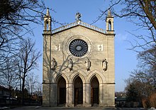
- The Church of St. Martin ( Kościół św. Marcina ) was built in the 19th century according to plans by Charles Percier , Léonard Fontaine and Karl Friedrich Schinkel .
- the Vauxhal Palace
- the Chapel of St. Stanislaus ( Kaplica pw.Św.Stanisława )
- the Chapel of Our Lady ( Kapliczka pod Matką Boską )
traffic
State road 79 ( droga krajowa 79 ) runs through the city from west to east . In an easterly direction, after about 17 kilometers, it leads to Kraków, where it runs together with state road 7 . In a westerly direction it runs through Chrzanów after 15 kilometers . Highway 4 runs about five kilometers south of Krzeszowice , the next entrance is at Rudno, six kilometers away .
Krzeszowice is located on the Dąbrowa Górnicza Ząbkowice – Kraków railway line .
The nearest international airport is John Paul II Airport, Krakow-Balice, about 14 kilometers to the southeast .
sons and daughters of the town
- Felicjan Szopski (1865–1939), composer, music teacher and critic
- Olga Drahonowska-Małkowska (1888–1979), founder of the Polish Scouting Association (with her husband Andrzej Małkowski)
- Stanislaw Czycz (1929–1996), poet
- Andrzej Adamczyk (* 1959), politician.
Web links
See also
Individual evidence
- ↑ Tomasz Jurek (editor): KRZESZOWICE ( pl ) In: Słownik Historyczno-Geograficzny Ziem Polskich w Średniowieczu. Edycja elektroniczna . PAN . 2010-2016. Retrieved April 22, 2019.
- ↑ a b Website of the city of Krzeszowice, Kalendarium historyczne Krzeszowic , accessed on May 1, 2010
- ↑ Ludwig Patryn (Ed.): Community encyclopedia of the kingdoms and countries represented in the Reichsrat, edited on the basis of the results of the census of December 31, 1900, XII. Galicia . Vienna 1907 ( online ).


