Księży Las (Zbrosławice)
| Księży Las Xiondslas |
||
|---|---|---|

|
|
|
| Basic data | ||
| State : | Poland | |
| Voivodeship : | Silesia | |
| Powiat : | Tarnowskie Góry (Tarnowitz) | |
| Gmina : | Zbrosławice (Broslawitz) | |
| Geographic location : | 50 ° 27 ' N , 18 ° 42' E | |
| Residents : | ||
| Telephone code : | (+48) 032 | |
| License plate : | STA | |
| Economy and Transport | ||
| Next international airport : | Katowice | |
Księży Las (German: Xiondslas ) is a village in Upper Silesia . It is located in the municipality of Zbrosławice (Broslawitz) in the powiat Tarnogórski (Tarnowitz district) in the Silesian Voivodeship .
geography
Księży Las is located five kilometers northwest of the municipality Zbrosławice , twelve kilometers west of the district town Tarnowskie Góry (Tarnowitz) and 31 kilometers northwest of the voivodeship capital Katowice (Kattowitz).
history
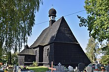
The place originated in the 13th century at the latest and was first mentioned in a document around 1302. The local church was first mentioned in a document in 1447. In 1494 today's scrap wood church was built.
The place was mentioned in 1783 in the book Beytrage describing Silesia as Xiondlos and Priestersdorf , belonged to a Herr von Strachwitz, was in the Tost district and had 171 inhabitants, a farm, a church, eleven farmers and 23 gardeners. In 1818 the place was mentioned as Prießersdorf and also as Xiondlas . In 1865 Xiondzlas consisted of a manor and a village community. The village had eleven farms, 23 gardeners and three cottages.
In the referendum in Upper Silesia on March 20, 1921, 53 eligible voters voted to remain with Germany and 210 for membership in Poland. Xiondslas remained with the German Empire . In 1936 the place was renamed Herzogshain . Until 1945 the place was in the district of Tost-Gleiwitz .
In 1945 the previously German place came under Polish administration and was renamed Księży Las and joined the Silesian Voivodeship. In 1950 the place came to the Katowice Voivodeship . In 1999 the place came to the re-established Powiat Tarnogórski and the new Silesian Voivodeship.
Sights and buildings
- On a hill, surrounded by the cemetery, is the Catholic Michael Church made of scrap wood from 1494 with additions from the 20th century and a roof turret. Baroque interior with a painting of the Archangel Michael.
- The old school from 1880
- Wayside crosses
coat of arms
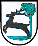
The coat of arms or seal shows game in front of a tree.
Notation
- Ksionslas (see seal, 19th century)
- Xiondslas
- Xiondzlas (around 1900)
Web links
Individual evidence
- ^ Zbrosławice municipality
- ^ Johann Ernst Tramp: Additions to the Description of Silesia, Volume 2 , Brieg 1783
- ^ Geographical-statistical handbook on Silesia and the county of Glatz, Volume 2 , 1818
- ↑ Felix Triest: Topographisches Handbuch von Oberschlesien , Breslau 1865
- ^ Results of the referendum in Upper Silesia of 1921: Literature , table in digital form ( Memento from January 15, 2017 in the Internet Archive )


