Przezchlebie
| Przezchlebie Preschlebie |
||
|---|---|---|

|
|
|
| Basic data | ||
| State : | Poland | |
| Voivodeship : | Silesia | |
| Powiat : | Tarnowskie Góry (Tarnowitz) | |
| Gmina : | Zbrosławice (Broslawitz) | |
| Geographic location : | 50 ° 22 ' N , 18 ° 41' E | |
| Residents : | ||
| Telephone code : | (+48) 032 | |
| License plate : | STA | |
| Economy and Transport | ||
| Next international airport : | Katowice | |
Przezchlebie (German: Preschlebie ) is a village in Upper Silesia . It is located in the municipality of Zbrosławice (Broslawitz) in the powiat Tarnogórski (Tarnowitz district) in the Silesian Voivodeship .
geography
Przezchlebie is eight kilometers southwest of the municipal seat Zbrosławice , 16 kilometers southwest of the district town Tarnowskie Góry ( Tarnowitz ) and 26 kilometers northwest of the voivodeship capital Katowice ( Katowice ).
The place is in the immediate vicinity of the southern independent city Gliwice ( Gleiwitz ) and its district Czechowice ( Schechowitz ).
history
The place was mentioned in 1783 in the book Additions to the Description of Silesia as Przechleb , belonged to a Mr. General von Werner and was in the Tost district and had 94 inhabitants, a farm, six farmers and 16 gardeners. In 1818 the place was mentioned as Przechleb . In 1865 Przezchlebie had a farm, a forester, 17 gardeners, 18 half-gardeners, a housekeeper, four stately chamber houses, a Kretscham (restaurant) and a watermill called Jelina watermill. The residents of the community went to school after Ziemientzitz.
In the first half of the 20th century, large quantities of sand were extracted south of the village.
In the referendum in Upper Silesia on March 20, 1921, 85 eligible voters voted to remain in Germany and 353 to belong to Poland. Preschlebie remained with the German Empire . Around 1933 the place was renamed Sandwiesen in the wake of a wave of renaming during the Nazi era . Until 1945 the place was in the district of Tost-Gleiwitz .
In 1945 the previously German town came under Polish administration and was then attached to the Silesian Voivodeship and renamed the Polish Przezchlebie . In 1950 the place came to the Katowice Voivodeship . Sand was mined for the last time in 1955, the pits were then flooded and the quarry ponds were used for local recreation until 1965. Then they were filled with excavated earth from the mining of the Upper Silesian industrial area. In 1999 the place came to the re-established Powiat Tarnogórski and the new Silesian Voivodeship.
Attractions
- Neo-Gothic chapel with a small bell tower and a facade made of red bricks
- Wayside crosses
coat of arms
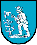
The coat of arms or seal shows a worker with a hat who knocks a small tree with an ax. The coat of arms indicates the rural character of the place. The latest version shows the worker and the tree in silver on a blue background.
Web links
Individual evidence
- ^ Johann Ernst Tramp: Additions to the Description of Silesia, Volume 2 , Brieg 1783
- ^ Geographical-statistical handbook on Silesia and the county of Glatz, Volume 2 , 1818
- ↑ Felix Triest: Topographisches Handbuch von Oberschlesien , Breslau 1865
- ^ Results of the referendum in Upper Silesia of 1921: Literature , table in digital form ( Memento from January 15, 2017 in the Internet Archive )
- ↑ Eksploatacja i mozliwości zagospodarowania centralnego zwałowiska odpadów powęglowych Przezchlebie w gminie Zbrosławice , Gliwice 201
- ^ Zbrosławice municipality


