Laurens (Iowa)
| Laurens | |
|---|---|
|
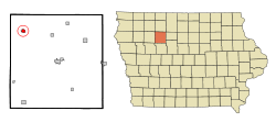
Location in Iowa
|
|
| Basic data | |
| Foundation : | 1881 (settled) 1890 (incorporated) |
| State : | United States |
| State : | Iowa |
| County : | Pocahontas County |
| Coordinates : | 42 ° 51 ′ N , 94 ° 51 ′ W |
| Time zone : | Central ( UTC − 6 / −5 ) |
| Residents : | 1,180 (as of 2015) |
| Population density : | 624.3 inhabitants per km 2 |
| Area : | 1.89 km 2 (approx. 1 mi 2 ) |
| Height : | 399 m |
| Postal code : | 50554 |
| Area code : | +1 712 |
| FIPS : | 19-43725 |
| GNIS ID : | 458243 |
| Website : | laurens-ia.com |
| Mayor : | Rod Johnson |
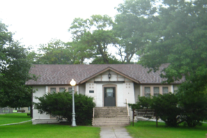
 The Laurens Carnegie Free Library , listed on the NRHP since 1974 |
|
Laurens is a small town (with the status " City ") in Pocahontas County in the US -amerikanischen State Iowa . In 2010 Laurens had 1258 inhabitants, the number of which had decreased to 1180 by 2015.
geography
Laurens is located in the central northwestern Iowa on the western shore of Cedar Creek , which over the Raccoon River and the Des Moines River to the basin of the Mississippi belongs.
The intersections of the states of Iowa, South Dakota and Minnesota and the states of Iowa, South Dakota and Nebraska are located on the Missouri River , 210 km northwest and 167 km west-southwest of Laurens.
The geographic coordinates of Laurens are 42 ° 50 '48 "north latitude and 94 ° 51' 07" west longitude. The city covers an area of 1.89 km² and is the largest town within the Swan Lake Township .
Neighboring towns of Laurens are Ayrshire (14 miles north), Curlew (15 miles northeast), Mallard (15 miles northeast), Plover (22.2 miles east-northeast), Havelock (8.4 miles east), Ware (13th district) , 6 km southeast), Pocahontas (25.9 km in the same direction), Albert City (15.8 km southwest), Marathon (12.1 km west), and Webb ( 15.8 km northwest).
The closest major cities are the Twin Cities in Minnesota ( Minneapolis and Saint Paul ) (334 km northeast), Rochester , Minnesota (306 km northeast), Cedar Rapids (340 km east-southeast), Iowa's capital, Des Moines (245 km southeast), Kansas City in Missouri (459 km south), Nebraska's largest city, Omaha (253 km southwest), Sioux City (156 km south-southwest), and South Dakota's largest city, Sioux Falls (223 km northwest).
traffic
The west-east running Iowa Highway 10 runs through the southwest portion of the Laurens metropolitan area. All other roads are subordinate country roads, some unpaved roads and inner-city connecting roads.
A single-track railway line that is used for regional freight transport runs through Laurens.
With the Pocahontas Municipal Airport is located 26 km southeast of the small airfield for general aviation . The nearest commercial airports are Des Moines International Airport (240 km southeast), Eppley Airfield in Omaha (243 km southwest), Sioux Gateway Airport in Sioux City (168 km west southwest) and Sioux Falls Regional Airport (244 km northwest).
| Population development | |||
|---|---|---|---|
| Census | Residents | ± in% | |
| 1890 | 318 | - | |
| 1900 | 853 | 168.2% | |
| 1910 | 817 | -4.2% | |
| 1920 | 914 | 11.9% | |
| 1930 | 1071 | 17.2% | |
| 1940 | 1304 | 21.8% | |
| 1950 | 1556 | 19.3% | |
| 1960 | 1799 | 15.6% | |
| 1970 | 1792 | -0.4% | |
| 1980 | 1606 | -10.4% | |
| 1990 | 1550 | -3.5% | |
| 2000 | 1476 | -4.8% | |
| 2010 | 1258 | -14.8% | |
| 2015 estimate | 1180 | -6.2% | |
| 1890-2000 2010-2015 | |||
history
The village was created in 1881. It was named after the Huguenots Henry and John Laurens . In 1890 Laurens was incorporated as an independent municipality.
population
According to the 2010 census , there were 1258 people in 571 households in Laurens. The population density was 665.6 inhabitants per square kilometer. Statistically, 2.15 people lived in each of the 571 households.
The racial the population was composed of 97.5 percent white, 0.3 percent African American, 0.4 percent Native American, 0.3 percent Asian, 0.2 percent Polynesian and 0.6 from other ethnic groups; 0.6 percent were descended from two or more races. Hispanic or Latino of any race was 1.4 percent of the population.
22 percent of the population were under 18 years old, 56.8 percent were between 18 and 64 and 21.2 percent were 65 years or older. 50.7 percent of the population were female.
The average annual income for a household was in 2015 at 38,125 USD . The per capita income was $ 27,437. 11.5 percent of the population lived below the poverty line.
Movie
Laurens is the starting point of the film A True Story - The Straight Story by David Lynch , which is based on the true story of Alvin Straight , a pensioner then living in Laurens . This is where the journey to Mounkt Zion, Wisconsin begins on a mounted lawn mower.
Personalities
- Fred C. Gilchrist (1868–1950) - Republican member of the US House of Representatives (1931–1945) - practiced as a lawyer in Laurens, died and is buried here
- Donald Norland (1924–2007), diplomat, born in Laurens
Individual evidence
- ↑ City of Laurens - City Council.Retrieved January 29, 2017
- ↑ Extract from the National Register of Historic Places - No. 74000804. Retrieved January 29, 2017
- ↑ a b c American Fact Finder. Retrieved January 29, 2017
- ↑ Distance information according to Google Maps. Accessed on January 29, 2017
- ↑ AirNav.com - Pocahontas Municipal Airport Accessed on 29 January 2017
- ↑ State Data Center of Iowa (PDF; 86 KB). Retrieved January 29, 2017
- ^ The Pioneer History of Pocahontas County, Iowa. Retrieved January 29, 2017
- ↑ city-data.com - Laurens, Iowa. Retrieved January 29, 2017
- ^ Biographical directory of the United States Congress - Fred C. Gilchrist.Retrieved January 29, 2017
- ^ Find a Grave - Fred Cramer Gilchrist. Retrieved January 29, 2017
