List of cultural monuments in Wachenheim an der Weinstrasse
In the list of cultural monuments in Wachenheim an der Weinstrasse , all cultural monuments of the Rhineland-Palatinate city of Wachenheim an der Weinstrasse are listed. The basis is the list of monuments of the State of Rhineland-Palatinate (as of November 29, 2016).
Monument zones
| designation | location | Construction year | description | image |
|---|---|---|---|---|
| Monument zone cemetery | Friedelsheimer Strasse location |
1829 | Layed out in 1829, in 1909, 1962 and expanded in the 1980s, some of the walls were originally built; Cemetery cross, sandstone, around 1842, metal body from the second half of the 19th century; Gravestones: three nameless cast-iron grave crosses, probably around 1870/80, another around 1880; L. Hefele family, blacksmithing, around 1900; G. Wendel († 1910), elaborate grave cross, around 1870/80; E. Kieser († 1892), around 1890 by Gottfried Renn , Speyer; Pastor J. Krack († 1900), niche with sculpture; KE Schirk († 1858), neo-renaissance aedicula, around 1880; Family tombs: Böhm-Sturm family, walled complex, shell limestone sculpture, around 1915; GF Kuhn family, shell limestone, antiqued, around 1920; Erich Heidschuch family , four shell limestone sculptures, around 1915 |

|
| Jewish cemetery monument zone | Römerweg location |
before 1579 | one of the oldest and most important Jewish cemeteries in the region; Mentioned for the first time in 1579, late 17th and 18th centuries, expanded after 1804 and 1874, walling 18th century or older; Cemetery hall, open wooden construction with half-timbered walls, marked 1895; several hundred tombstones, the oldest from 1725; Rechle, wife of Eisek Meir, died 1843, Gothic stele; Vogel, wife of Seew Halewi, died 1849, classicist stele; N. Mayer, died 1894, D. Weil, died 1905, A. Loeb, died 1910; granite obelisk with a pedestal; G. Jonas, died 1912, granite obelisk; elaborate grave complex of the Mayer family, late 19th and early 20th century; S. Mayer, died 1916, granite obelisk; R. Kaufmann, died 1925, sarcophagus; A. Netter, died 1872, marble pillar crowned with vases; A. Joch, died 1882, sandstone |
 more pictures more pictures
|
| Monument zone city fortifications | Bahnhofstrasse 6–16 (even numbers), 19, Bleichstrasse 5, 7, 10, Burgstrasse 1, 3, 4, Entengasse 1, 3, 6, 9, Hintergasse 1, 3, 5, 8–10, 13, 14, Holzgasse 3, 8, 8a, 9, 10, 13-15, Langgasse 22, 27, 29, 30, 34, Mühlgasse 7, 11, 16-18, Weinstraße 17, 19, 65, 74, 77, 78 | 1341 | City wall erected as a result of the granting of city rights in 1341, preserved in its entire original length, partially included in adjacent buildings, preserved parts of towers as well as the proportion of undeveloped land on the city wall; The region's city wall is seldom preserved in the preserved extent | |
| Monument zone in the city center | Amalie-Helfrich-path, Bahnhofstraße, Bleichstraße, Burgstraße, Dalberggasse, Grabenstraße, Hintergasse, Hinterm Graben, Holzgasse, Langgasse, Mittelgasse, Mühlgasse, Kommerzienrat-Wagner-Straße, Weinstraße location |
from the 16th century | Core city within the city fortifications built in 1341, including the former moat and the adjacent paths, characteristic floor plan of a so-called founded city in the ladder system, building fabric dating back to the 16th century |

|
| Monument zone castle ruins Wachtenburg | west of the city on the Zieglerberg; Hallway Am Schloßberg location |
Mid 12th century | probably founded in the middle of the 12th century, Upper Castle and Lower Castle, destroyed in 1571, partially restored, ruin since 1689 (demolition of the keep); Remnants of the keep of the Upper Castle, 12th and 13th centuries, ring wall with five towers, 13th century (?); defining the townscape |
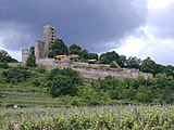 more pictures more pictures
|
| Monument zone Roman estate | northeast of the city on the B 271 ; Corridor at the east courtyard location |
around 20 AD | Villa rustica, remains of wooden buildings from around 20 AD, erected in stone in the 3rd century, preserved individual wall sections of the risalit villa, farm buildings, well, kiln and threshing floor |
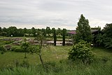 more pictures more pictures
|
Individual monuments
| designation | location | Construction year | description | image |
|---|---|---|---|---|
| Door run | Am Anger, at No. 1b Lage |
1605 | Gate drive, Renaissance, marked 1605, capitals probably from the 18th century | |
| Door run | Bahnhofstrasse, at No. 1 location |
around 1800 | Gate ride, classicist motifs, around 1800 |

|
| Residential building | Bahnhofstrasse 3 location |
1736 | late baroque hipped roof building with elaborate portal, marked 1736, architect allegedly Johann Georg Stahl , Bruchsal; Gate run marked 1618 |
 more pictures more pictures
|
| city wall | Bahnhofstrasse, behind No. 6–16 (even numbers) location |
Mid 14th century | Remnants of the city wall, mid-14th century | |
| Courtyard | Bahnhofstrasse 7 location |
second half of the 18th century | late baroque three-sided courtyard, second half of the 18th century; Residential house, partly half-timbered, with gallery, outbuildings from the period of construction |
 more pictures more pictures
|
| Courtyard | Bahnhofstrasse 9 location |
18th century | late baroque former winery, 18th century on remains of the 16th century; Residential house, partly half-timbered (plastered), marked 1595, basement exit marked 1727; Part of a keystone, marked 1583 |
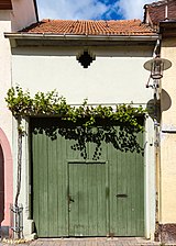
|
| Residential building | Bahnhofstrasse 10 location |
around 1600 | Residential house, in the core around 1600 | |
| Residential building | Bahnhofstrasse 12 location |
1736 | One-storey high-rise basement building in late baroque style, doorway marked 1736, basement exit marked 1745, skylight portal marked 1753 | |
| Door travel and cellar exits | Bahnhofstrasse, at No. 13 and 15 location |
around 1600 | at No. 15 door run with house brand , marked 1617; Simultaneous remains of a cellar exit with a coat of arms; at no. 13 in the courtyard, the second of the two cellar exits, around 1600, and a man gate |
 more pictures more pictures
|
| Spoilage | Bahnhofstrasse, at No. 14 location |
1666 | Wedge stone of a doorway, relief, inscribed 1666 | |
| City wall tower | Bahnhofstrasse, at No. 16 location |
Mid 14th century | Remainder of the former city wall tower on the southeast corner of the city wall ring |
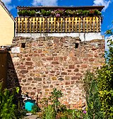
|
| city wall | Bahnhofstrasse, behind No. 19 location |
Mid 14th century | Remnants of the city wall, mid-14th century | |
| Residential and commercial building | Bahnhofstrasse 23 location |
1879 | Villa-like historicist residential and commercial building, 1879 |
 more pictures more pictures
|
| villa | Bahnhofstrasse 31 location |
1909 | Wilhelminian style villa with half-hipped roof, Heimat- and Art Nouveau motifs, inscribed 1909, architect Franz Huber , Neustadt |
 more pictures more pictures
|
| Residential building | Bahnhofstrasse 33 location |
1902 | Villa-like late historical house on an asymmetrical floor plan, 1902 |
 more pictures more pictures
|
| villa | Bahnhofstrasse 54 location |
1891 | representative Wilhelminian style villa with a mansard hipped roof, 1891, outbuildings from the construction period |

|
| city wall | Bleichstrasse, behind No. 5, 7, 10 location |
Mid 14th century | Remnants of the city wall, mid-14th century | |
| city wall | Burgstrasse, to No. 1, 3 position |
Mid 14th century | Remnants of the city wall, mid-14th century | |
| city wall | Burgstrasse, opposite No. 3 location |
Mid 14th century | Remnants of the city wall, mid-14th century | |
| Gate drives | Burgstrasse, at No. 55, 57 Lage |
17th century | Gate drives, No. 55 possibly from the 17th century, No. 57 marked 1801 | |
| Courtyard | Dalberggasse 3 location |
1574 | sandstone-integrated plastered building with stair tower, marked 1574, partly from the 18th century, single-storey stable and remisent tract, 18th century, with doorway, marked 1574 | |
| Dalberger Hof | Dalberggasse 4 location |
18th century | former noble court of the barons of Dalberg; Dreiseithof, mainly from the 18th century; Manor house, twelve-axis hipped roof building, marked 1717, vaulted cellar 16th or 17th century, single-storey stable wing, 18th century, keystone marked 1572, shed 18th century | |
| city wall | Entengasse, behind No. 3, 6, 9 location |
Mid 14th century | Remnants of the city wall, mid-14th century | |
| Schwedenhof | Entengasse 6 location |
18th and 19th centuries | Courtyard, 18th and 19th centuries; One-storey plastered building, mid-18th century, above an older cellar, farm building around 1870 | |
| Spoilage | Gartenweg, at No. 17 location |
18th century | Keystone of a former gateway, with coat of arms, 18th century | |
| Spoilage | Grabenstrasse, at No. 1½ location |
1592 | former lintel of a gate, with coat of arms, inscribed 1592 | |
| Spoilage | Hintergasse, at No. 1 location |
1614 | Keystone of a former gateway, with coat of arms, inscribed 1614 | |
| city wall | Hintergasse, in No. 1, 3, 5, 8-10, 13, 14 position |
Mid 14th century | in the back of the houses remains of the city wall, mid-14th century | |
| Residential building | Back alley 2 location |
18th century | House, 18th century, over older remains; House brand denotes 1568; Basement window, three-part arcade, probably Romanesque or Gothic; Gate travel around 1600 | |
| Window walls and gate system | Back alley, at No. 4 location |
17th century | Window frames, marked 16 [xx]; Gate system, marked 1731 | |
| Spoilage | Hintergasse, at No. 5 location |
1801 | Keilstein, relief, inscribed 1801 | |
| Residential building | Back alley 6 location |
1606 | L-shaped house with Renaissance walls, in the core from 1606, heightened in the 19th century | |
| Door run | Hintergasse, at No. 7b location |
1781 | Gate run, marked 1781 | |
| Portal garments | Hintergasse, at No. 8 location |
around 1600 | Portal walls, around 1600 | |
| Window frames | Hintergasse, at No. 9 location |
around 1600 | Window frames, around 1600 | |
| Courtyard | Hintergasse 16 location |
1594 | former estate; Plastered building in the core from 1594, roof truss largely original, coat of arms keystone marked 1594 | |
| City wall tower | Behind the ditch, at No. 2 location |
Mid 14th century | Wall shell of the eastern city wall tower, originally free-standing in front of the city wall, mid-14th century | |
| city wall | Holzgasse, in No. 3, 8, 8a, 9, 10, 14 position |
Mid 14th century | in the back of the houses remains of the city wall, mid-14th century | |
| Theft | Holzgasse, in No. 9 position |
after 1341 | Two-storey round tower integrated into the rear courtyard building at the northwest corner of the city fortifications | |
| Goalposts | Holzgasse, at No. 10 location |
1584 | Goal post, marked 1584 | |
| Coat of arms stone | Holzgasse, at No. 13 location |
1598 | Wappenstein with two coats of arms, inscribed 1598 | |
| Wachenheim Castle Sekt winery | Kommerzienrat-Wagner-Straße 1 location |
from 1833 | extensive winegrowers' estate in an English landscape park; Late Baroque Sussmann's manor house, around 1730, the rest of the buildings surrounding the courtyard mostly from 1833 ff .; inside the transverse building from 1903/04 Halle, 1927, architects Reimers and Pommerenke; sandstone fountain in the courtyard, around 1930; extensive cellar, 1883 ff. rear boundary of the garden by a city wall, mid-14th century |
 more pictures more pictures
|
| Reformed schoolhouse | Kommerzienrat-Wagner-Straße, to No. 1 location |
1733 | former reformed schoolhouse; late baroque building, upper floor half-timbered, 1733 | |
| Münzhof | Langgasse 2, 2a location |
from the 16th century | No. 2 former gatehouse and guard house, single-storey late Baroque hipped roof building, core from the 16th century, remodeled in the 18th century, late Classicist extension in the first half of the 19th century, former Burgvogteihaus, large-volume late Baroque half-hipped roof building, 1754, architect Franz Wilhelm Rabaliatti ; No. 2a quarry stone barn and remise extension, 1781 |

|
| Lutheran parish church | Langgasse 6 location |
1748 | former Lutheran parish church; late baroque hall building with bell tower, marked 1748, architect Sigismund Zeller ; in the adjoining wall gate, marked 1619 |
 more pictures more pictures
|
| Garden gate | Langgasse, at No. 19 location |
1599 | Fragment of a garden gate, with coat of arms stone, inscribed 1599 | |
| city wall | Langgasse, behind No. 22, 27, 29 Lage |
Mid 14th century | in the back of the houses remains of the city wall, mid-14th century | |
| Door run | Langgasse, at No. 25 location |
17th century | Gate drive, probably from the 17th century | |
| relief | Langgasse, at No. 27 Lage |
1708 | Sandstone relief, in three parts, inscribed 1708, by Johann Georg Eisinger | |
| Door run | Langgasse, at No. 32 Lage |
around 1600 | Gate drive, around 1600 | |
| Robes | Langgasse, at No. 36 Lage |
from 1600 | Walls of the courtyard entrance, marked 1706; two window frames, around 1600 | |
| Architectural parts | Langgasse, at No. 41 Lage |
from 1617 | door frames with a late Gothic profile, marked 1617; Vaulted cellar; Lintel, 1790; Door run | |
| Residential building | Langgasse 42 location |
18th century | late baroque house, partly half-timbered, 18th century, older in core; Lion head mask, inscribed 1653 | |
| Residential building | Langgasse 43 location |
around 1800 | single-storey neighbourhood house, around 1800, cellar partly around 1600, basement exit marked 1747; Vaulted stable around 1840 | |
| Zehnthof | Mittelgasse 1 location |
two-winged mansion, gate drive marked 1595, over-cornered gable roof and bay window 18th century (probably 1773), press house 18th century over remains of the 16th century, servants' house, partly half-timbered, as well as former stable, 16th and 18th centuries; defining the streetscape | ||
| Residential building | Mittelgasse 7 location |
second half of the 18th century | late baroque high-cellar building with a mansard gable roof, second half of the 18th century | |
| portal | Mittelgasse, at No. 8 location |
1617 | Portal, marked 1617, to the left of it window frames | |
| Residential building | Mühlgasse 1 location |
1746 | late baroque corner house, partly half-timbered, marked 1746; defining the streetscape | |
| Residential building | Mühlgasse 3 location |
1746 | late baroque house, partly half-timbered, probably from 1746, over remains of the 16th century | |
| Residential building | Mühlgasse 4 location |
1739 | late baroque corner house, partly half-timbered, marked 1739 | |
| Mühlgasse 7 location |
16th Century | Courtyard, in the core from the 16th century, modernized or partially renovated in the 18th, 19th centuries and later; Hochkeller marked 1746, stone sliding window 16th century; Keystone of the former gateway, 18th century | ||
| city wall | Mühlgasse, in no. 7, 11, 16-18 positions |
Mid 14th century | in the back of the houses remains of the city wall, mid-14th century | |
| Residential building | Mühlgasse 8 location |
around 1600 | Residential house, partly half-timbered (plastered), the core around 1600, in the 18th century (marked 1723) and later overformed | |
| Courtyard | Mühlgasse 11 location |
16th to 19th century | Courtyard, 16th to 19th centuries; Renaissance archway, marked 1576; Remains of a former outbuilding, 16th century; Residential and side wing designated 1571, half-timbered upper floor 18th century; single-storey house above the basement, marked 1576, remodeled in the 18th century; Reservation 16th century, half-timbered upper floor 18th century | |
| Door run | Mühlgasse, at No. 20 location |
around 1600 | Gate and parts of the walls, around 1600 | |
| villa | Roter-Turm-Weg 1 layer |
1826/27 | stately classicist hipped roof villa, 1826/27 | |
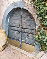
| portal | Schlossgasse, at No. 10 location |
1578 | Portal, marked 1578, access to the basement |
|
| Courtyard | Schlossgasse 28 location |
16th Century | former Burgmannenhaus; Single-storey plastered building, late Gothic core, 16th century, partially renovated in the 18th century and later, extension to the Hakenhof | |
| Lower castle | Schlossgasse 29 location |
around 1600 | Site of the so-called Lower Castle; Former burgrave house, partly around 1600, alterations in the 18th century, expansion as a summer residence in 1886, later further alterations and extensions | |
| Goalposts | Waldstrasse, at No. 39 location |
1736 | Fragment of the former doorway, keystone in relief on the post, inscribed 1736 | |
| Castle or castle mill | Waldstrasse 53 location |
1799 | Site of the former castle or castle mill; Residential house and outbuildings, in the core from 1799, gate drive marked 1793 | |
| Door frames | Waldstrasse, at No. 62 Lage |
16th Century | Entrance walls, probably from the 16th century | |
| Residential building | Waldstrasse 102 location |
second half of the 18th century | late baroque hipped roof building, partly half-timbered (plastered), probably from the second half of the 18th century | |
| Johann Ludwig Wolf Erben winery | Weinstrasse 1 location |
1843 | representative historicist hipped roof villa with lower wings, 1843, architect Eisenlohr, Karlsruhe, six sandstone sculptures on the terrace, fountain in the English Garden around 1930, garden edging including gate around 1880; Inner courtyard with outbuildings around 1880, shed before 1930, one and a half-story plastered building marked 1843 | |
| LH Wolf winery | Weinstrasse 4 location |
in the middle of the 19th century | rich winery, mid-19th century; Stately residential building and utility wing, two classicist hipped roof buildings, around 1845, elaborate gate system, outbuildings in the courtyard, plastered buildings, around 1855, tea house in the English garden | |
| Guard house | Weinstrasse 15 location |
1829/30 | former guard house; single-storey classicist hipped roof building with open vestibule, 1829/30, architect Fritz, Neustadt | |
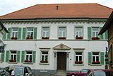
| Council and school house | Weinstrasse 16 location |
1828 | former town hall and school building; Large-volume classicist hipped roof building, marked 1828 |
|
| Residential building | Weinstrasse 17 location |
around 1800 | Neighboring baroque winegrower's house, around 1800 | |
| city wall | Weinstrasse, in No. 17, 19, 65, 75, 77, 78 position |
Mid 14th century | in the back of the houses remains of the city wall, mid-14th century | |
| Wachenheimer, Leininger or Falkenburger Hof | Weinstrasse 19 location |
1711 | late baroque manor house, 1711; Large-volume hipped roof building over a high cellar, 16th and 18th centuries, gate system marked 1711 | |
| Spoilage | Weinstrasse, at No. 21 location |
1677 | Console stone with sheet mask, marked 1677 | |
| Brother Ludwig Chapel | Weinstrasse 27 location |
15th century | former Brother Ludwig Chapel; late Gothic sandstone cuboid hall construction, probably from the 15th century (1443?)
Characteristic of the townscape with the Simultankirche (Weinstrasse 28). |
 more pictures more pictures
|
| Simultaneous Church of St. George | Weinstrasse 28 location |
12th Century | Picturesque staggered assembly Tower possibly from the 12th century, bell storey 1686–88, elevation marked 1712. |
 more pictures more pictures
|
| Processional altar | Weinstrasse, at No. 28 location |
1707 | monumental yellow sandstone altar, allegedly by Johann Georg Eisinger, Pietà in 1707, second half of the 16th century | |
| Residential building | Weinstrasse 29 location |
18th century | late baroque former corner house, partly half-timbered, 18th century, core from the 16th century (marked 1542), basement exit marked 1677; defining the streetscape | |
| Catholic rectory | Weinstrasse 31 location |
1736/38 | former catholic rectory; Five-axis house, 1736/38 with changes from 1818 | |
| Inscription plate | Weinstrasse, at No. 34 location |
1508 | Inscription plate, late Gothic, inscribed 1508 | |
| Residential building | Weinstrasse 36 location |
late 18th century | stately late baroque mansard hipped roof building, late 18th century, extension with mansard gable roof in 1927; defining the townscape | |
| portal | Weinstrasse, at No. 37 location |
1756 | Skylight portal on the rear annex of the former reformed rectory, late baroque, 1756 | |
| Spoilage | Weinstrasse, at No. 39 location |
17th century | Keystone of the (renewed) gate drive with sheet mask, probably from the 17th century | |
| Courtyard | Weinstrasse 44 location |
1606 | Former winery, single-storey plastered building, mainly from 1606, baroque remodeling probably 1782, outbuildings mostly from the 18th century with older remains, courtyard wall with gate, inscribed 1607 | |
| Door run | Weinstrasse, at No. 46 location |
1725 | Gate drive, late baroque with coat of arms stone, marked 1725; two more keystones in the wall | |
| Spoilage | Weinstrasse, at No. 48 location |
1578 | Keystone of the former gateway with coat of arms, inscribed 1578 | |
| Door run | Weinstrasse, at No. 52 location |
1578 | former gate drive, band rustica, coat of arms inscribed 1578 | |
| Courtyard | Weinstrasse 54 location |
18th century | late baroque courtyard, 18th century (1786?); late baroque corner house with crooked hip, red sandstone facing of the facade around 1880, extension with square gate, upper floor of the courtyard-side extension possibly from the 16th or 17th century, cellar exit marked 1617; defining the plaza | |
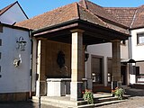
| Luisenbrunnen | Weinstrasse, next to No. 59 location |
1914 | Shell limestone trough, cast iron fountain outlet, hip roof supported by four pillars, inscribed 1914, by Heinrich Berthold , Munich |
|
| Bürklin-Wolf winery | Weinstrasse 65 location |
1844 | House of the Wolf family, two-and-a-half-storey historical building with hipped roof, ancillary building on an L-shaped floor plan with gates, in the core from 1844 with modernization around 1875; Residence for Dr. A. Bürklin, sophisticated Wilhelminian style house on a T-shaped floor plan, marked 1890; Storage and drying house, one and a half storey sandstone block construction; opulent street layout; Remains of the Wartenbergschen Hof: gate drive in the courtyard wall to Holzgasse, marked 1609, coat of arms stone on the rear wing, probably from the 16th century |

|
| Residential building | Weinstrasse 70 location |
1615 | Corner house, in the core marked 1615, late Baroque remodeling in the 18th century, elaborate man gate, marked 161 [5]; defining the streetscape | |
| Residential building | Weinstrasse 71 location |
first half of the 18th century | late baroque corner house, partly half-timbered (plastered), with crooked hip, first half of the 18th century; Sandstone cuboid, remnants of a former gateway, around 1600 | |
| Door run | Weinstrasse, at No. 74/75 location |
1745 | Gate drive, late baroque, marked 1745 | |
| High basement building | Weinstrasse 77 location |
16th Century | High-cellar building, partly half-timbered (plastered), with remains of the city wall, the core from the 16th century, heightened and remodeled in the 18th century; Pillar of a gateway, 16th century | |
| hospital | Weinstrasse 80, 80a location |
1883-85 | No. 80 former hospital; Sophisticated nine-axis Wilhelminian style building on a U-shaped floor plan with mansard hipped roofs, the risalit flanking four sandstone sculptures, 1883–85; associated no. 80a: former work school; sandstone-integrated plastered building with wooden loggia |

|
| War memorial | Weinstrasse, opposite No. 80 location |
1911 | War memorial 1866 and 1870/71, raised sandstone pillar, imperial eagle in shell limestone, 1911 by Heinrich Berthold, Wachenheim, extended after 1945 for the fallen of both world wars |

|
| Wayside cross | Weinstrasse, corner of Roter-Turm-Weg Lage |
1745 | Road cross, red sandstone, marked 1745 | |
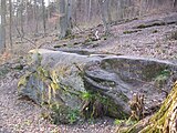
| Stone wine press | northwest of the city in the Poppental location |
Boulder with drainage channel, probably prehistoric or early |
 more pictures more pictures
|
|
| Weather cross | northwest of the city and east of the Mundhardter Hof; District Am Kreuzberg location |
1513 | Inscription in Gothic minuscule, inscribed 1513 |
 more pictures more pictures
|
| Christophel shoe | southwest of the city on Eckkopf ; District in the rear Lathstatt location |
before 1784 | Boulder with incised drawings, named 1784 |
 more pictures more pictures
|
| Forest farm Odins Valley | southwest of the city in the Odins Valley location |
from 1830 | Manor house, classicist hipped roof building, from 1830 |

|
literature
- Georg Peter Karn, Rolf Mertzenich: Bad Dürkheim district. City of Bad Dürkheim, municipality of Haßloch, municipalities of Deidesheim, Lambrecht, Wachenheim (= cultural monuments in Rhineland-Palatinate. Monument topography of the Federal Republic of Germany . Volume 13.1 ). Wernersche Verlagsgesellschaft, Worms 1995, ISBN 3-88462-119-X .
- General Directorate for Cultural Heritage Rhineland-Palatinate (Ed.): Informational directory of cultural monuments in the Bad Dürkheim district (PDF; 5.1 MB). Mainz 2016.