Loferbach (Saalach)
|
Loferbach Strubache, Strubbach, Haselbach, Grieselbach |
||
|
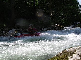
Descent with the white water canoe |
||
| Data | ||
| Water code | AT : HZB: 2-008-272-285-097 | |
| location | District Kitzbühel / Tyrol, Pinzgau / Salzburg; Loferer Steinberge | |
| Drain over | Saalach → Salzach → Inn → Danube → Black Sea | |
| River basin district | Danube to Jochenstein | |
| Origin as Gries [e] l [tal] bach | at the high column 47 ° 31 ′ 5 ″ N , 12 ° 38 ′ 42 ″ E |
|
| Source height | 1387 m above sea level A. | |
| Estuary as Loferbach | in Lofer coordinates: 47 ° 35 ′ 9 ″ N , 12 ° 41 ′ 58 ″ E 47 ° 35 ′ 9 ″ N , 12 ° 41 ′ 58 ″ E |
|
| Mouth height | 620 m above sea level A. | |
| Height difference | 767 m | |
| Bottom slope | 29 ‰ | |
| length | 26.6 km | |
| Catchment area | 107.4 km² | |
| Discharge at the Lofer gauge (Loferbach) A Eo : 107.4 km² Location: 20 m above the mouth |
MNQ 1961–2011 MQ 1961–2011 Mq 1961–2011 MHQ 1961–2011 HHQ (86.0) |
19.01 m³ / s 1.33 m³ / s 12.4 l / (s km²) 5.18 m³ / s 42 m³ / s |
| Left tributaries | Katzelbach, Weissbach | |
| Flowing lakes | Pillersee | |
| Communities | Sankt Ulrich am Pillersee , Waidring , Lofer | |
| Upper course Grieseltal , middle course Pillerseetal , lower course Strubtal | ||
The Loferbach , also called Haselbach , Grieselbach , Strubache or Strubbach , is a right tributary of the Saalach in the Salzburg / Tyrol border area .
Run, naming and landscape
The stream has its origin on the Tyrolean side of the Loferer Steinberge . It circles the mountain range almost completely and forms its western and northern borders. He changes his name several times.
It rises in the municipality of Sankt Ulrich am Pillersee as Grieselbach , also Grieslbach , Grießelbach or Grieseltalbach ( ⊙ ) am Hochsäul ( 1757 m above sea level ), northwest of the Römersattels , which forms the border between Leoganger and Loferer Steinbergen . It flows through the Grieseltal towards the west- south- west.
At Flecken , at the valley watershed of the Pillerseetal , it turns abruptly to the north, here the Moosbach flows to the Fieberbrunner Ache to the southwest. The Grieselbach then has the Steinberge in the east and the Kirchbergstock in the west ( ⊙ ). After a few kilometers it reaches the Pillersee near Pillersee , a mountain lake about 2 km long at 850 m above sea level. A. From St. Adolari it passes the Öfenschlucht and from Schöttl the stream is generally called Haselbach ( ⊙ ).
After a few kilometers it then reaches the village of Waidring and bends eastwards. Here the Pillerseetal ends, and from now on the valley of the Haselbach is called Strubtal , which is why it is also called Strubache or Strubbach from here on . Otherwise it is called to Strub , 4 km to Waidring, or to the Tyrolean border, 7 km to Waidring, still Haselbach , and then Loferbach ( ⊙ ). There is another valley watershed near Waidring: the Waldbach drains from the bend westwards to the Großache. The extension of the Strubtal to Erpfendorf is called Innerwald and Ausserwald , and the course of the river there takes on the name: Grießbach / Griesbach .
The northern edge of the Strubtal now forms the Sonnwand , the southern edge of Steinplatte and Loferer Alpe . At the state border, the stream also passes the Strub pass , the Telenge and old, fortified border guards of the Prince Archdiocese of Salzburg against Habsburg-Tyrol , over which the Loferer Straße (B 178) runs today . After a further 3 kilometers, the Loferbach reaches the town of Lofer , where it joins the Saalach from the left at 45.5 km .
More important tributaries are the Weißbach to the left of the Kirchberg ( 1678 m ) and Schafelberg ( 1597 m ) in the Kirchbergstock, and at the upper reaches the Katzelbach to the left (with Wiesensee ) with the valley watershed via Mitterwarming to Hochfilzen ( Wiesenseetal ) .
Web links
- Loferbach (Strubach) ( Memento from August 9, 2011 in the Internet Archive ), run description, paddeln.at
Individual evidence
- ↑ a b c d e f g TIRIS: Grießelbach (alternatively: Haselbach, Lofer ), Waters ID KURZRID: T4473R1, WIS ID: 618, WLKID: 104259
- ↑ a b c SAGIS: Loferbach , TWK-ID: 301230001, WIS-ID: A3144220
- ↑ a b Federal Ministry of Agriculture, Forestry, Environment and Water Management (ed.): Hydrographisches Jahrbuch von Österreich 2011. 119th volume. Vienna 2013, p. OG 138, PDF (12.9 MB) on bmlrt.gv.at (Yearbook 2011)
- ↑ a b c d e Austrian map 1: 50,000: Grieslbach to Pillersee, Griesel Bach to Schöttl, Haselbach to Strub, then Loferbach , all four in GEONAM Austria situates
- ↑ for example in: Ostalpen , bergalbum.de, Verbal description of the mountain groups; Basis: Alpine Club classification of the Eastern Alps in the Alpine Club Yearbook Berg '84 ; 9 Loferer and Leoganger Steinberge or 11 Chiemgau Alps
- ↑ a b especially in paddle literature
