
Lohmühlenstrasse (Berlin-Alt-Treptow)
| Lohmühlenstrasse | |
|---|---|
|
|
|
 |
|
| Lohmühlenstraße (view to the northeast) | |
| Basic data | |
| place | Berlin |
| District | Alt-Treptow |
| Created | July 26, 1897 |
| Connecting roads | In front of the Schlesisches Tor (north; before 1978) , Maybachufer (south) |
| Cross streets |
(Selection) Jordanstrasse , Kiefholzstrasse , Karl-Kunger-Strasse , Isingstrasse , Heidelberger Strasse , Jordanstrasse , Harzer Strasse |
| Places | Lohmühlenplatz |
| Buildings | see: Buildings |
| use | |
| User groups | Pedestrian traffic , bicycle traffic , car traffic , public transport |
| Technical specifications | |
| Street length | 680 meters |
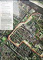
The Lohmühlenstraße is located in the Berlin district of Alt-Treptow , a smaller portion in the district of Kreuzberg was deconsecrated 1978th It is named after several tinder mills, which are no longer preserved today, which processed oak and spruce bark ( tan ) into bark flour until the beginning of the 19th century . It was the oldest and until 1906 only street in the northern residential district of today's Alt-Treptow district.
course
The road begins at the Lohmühlenbrücke , which leads over the Neukölln shipping canal and connects the districts of Neukölln and Treptow-Köpenick . It runs over Lohmühlenplatz parallel to the Landwehr Canal , crosses under the former Berlin – Görlitz railway line at the level of Kiefholzstraße and reaches the Flutgraben behind Jordanstraße at Treptower Bridge . Before the last section was deedicated in 1978, it continued on the Lohmühleninsel to Before the Schlesisches Tor . This area was closed to motor traffic, it enables pedestrians and cyclists a car-free connection to the Puschkinallee and - via the Ernst-Heilmann-Steg, built in 1980 - to the Görlitzer Ufer in Kreuzberg .
history
In 1752, two loam mills were built on the then raft ditch (after the Landwehr Canal was expanded ), which were operated by the tanners Lutze and Busset. They are considered to be the first two commercially operated companies in the rural community of Treptow . There, wood, including from the Köllnische Heide , was processed. The location was favorable in another respect, because Lutze and Busset also fulfilled the requirement that inflammable trades could only be carried out outside the city gates. Presumably a meadow path was created for the transport of goods, which is shown for the first time on a map from 1783 with the name Kohlhorstweg . It led from the Schlesisches Tor past the Lohmühlen to the Vorderheide to the then still independent Rixdorf , a district of Neukölln since the 1930s . In 1842 the Lohmühlenweg appears on another map , which already had the current route. However, it was not completely in the Treptow area, but belonged to Rixdorf in the western part (from later house number 48). To the south of the street there was a field barn and a few houses that belonged to commercial nurseries that settled along the railway line after 1840. In the Berlin address book, the Lohmühlenweg is shown for the first time in 1874 with the course from Am Wiesenweg to An der Treptower Brücke without specifying parcel numbers.

The Busset Lohmühle burned down in 1860 and was never rebuilt. The leather factory of Carl Kampfmeyer, which later became the Dr. M. J. Salomon and Co. was convicted. With the expansion of the Rixdorf branch canal, which was extended from 1912 to 1913 to the Teltow Canal (currently Neuköllner Schifffahrtskanal ), the structure of the local businesses changed: the groundwater level sank by an average of two meters, making the location unprofitable for the horticultural companies that had previously been active there. Nevertheless, the location on the Landwehr Canal remained favorable for businesses; Instead of flowers, building materials and fuel were now transported into the city. Due to the proximity to the navigable Landwehr Canal, large storage areas were created on Lohmühlenstrasse at the turn of the 20th century, owned by the City of Berlin. For example, on property number 6 there was a wood storage area of the Union of Stellmacher Berlin , on properties 7-9 a storage area leased by Anilin-Fabrikation AG , the company Hedwigshütte, Anthrazit-Kohlen- und Cokeswerke J. Stevenson used the plot 10 Storage of coal . There were twelve more wood yards on plots 20–22, 23/24, 27–32, 33, 112/113, 114/115, 122/123, 129/130, 133, 134, 136 and 139 as well as a stone and a room . The Neumann smithy settled at the intersection with Strasse 36 (later Isingstrasse) . She took care of the teams that transported construction and fuel into the city from Lohmühlenstrasse.
In addition to traditional handicrafts, the first industrial companies came into being. The best known company was the chemical factory of Max August Jordan , which produced dyes and other chemical end products from December 11, 1850. On July 21, 1873, it was combined with the Gesellschaft für Anilinfabrikation mbH in Rummelsburg to form the Actien-Gesellschaft für Anilin-Fabrication , later known as Agfa . The preparations for the first Berlin trade exhibition in the nearby Treptower Park meant that the area continued to develop: the street was given a rough pavement in 1895/1896 ; Residential houses were built and BESTAG lines ran on the road until 1911. On July 26, 1897, the official name was given in "Lohmühlenstraße".
The council carpenter Robert Otto built the house number 46, which is still preserved today, in 1898. He owned a sawmill with a wood storage yard in the immediate vicinity . A year later the houses with the numbers 25 and 26 as well as 52 were added. All three were bombed and demolished during World War II . In house number 52 there was a post office for the Berlin postal delivery district 36. In the years that followed, additional residential buildings were built, some of which still exist, but some of which were also destroyed in the Second World War. After 1934 the Lucke block of flats was built with the complex from Grabowstrasse 9 to Schmollerplatz 12 and the houses at Lohmühlenstrasse 47-49. Lucke was also a timber merchant, whose descendants had a total of 16 houses with 202 apartments built on his land.


With the rise in residential construction, more and more industrial companies withdrew from Lohmühlenstrasse. One reason was the increasing number of complaints from residents about the emissions caused by the companies. A protocol of the district assembly from the 1920s recorded a complaint about the “bestial stench” emanating from the leather factory - in 1931 it finally gave up the production facility. The Reschke box factory was built in its place. In the 1930s, essentially only the IG Farben sales departments and the Agfa photography department remained of the rest of the trade . Nevertheless, there were also new settlements. The company Fritz Weber and Co. Metallwaren- und Laternenfabrik moved from Graetzstraße (since the 1970s: Karl-Kunger-Straße) to a site in Lohmühlenstraße 63 / Kiefholzstraße 1-4 (the house number sequence follows the principle of horseshoe numbering ) and built there from 1935 to 1940 a company complex. In the buildings with house numbers 1–4, Fritz Weber and Co. produced weapons for the Second World War. Among other things, he made use of some Soviet forced laborers who were housed in a camp at Lohmühlenstrasse 23 and 24. In the building opposite at number 55 there was a camp for foreigners in which people were also used for forced labor. At the time of National Socialism there was a restaurant of the Sturmabteilung at Lohmühlenstraße 60 . On June 21, 1944 and February 3, 1945, some heavy air raids by American bombers took place. They targeted the factory buildings in particular, but 20 residential buildings in the street were completely destroyed or had to be demolished afterwards. Three houses could be rebuilt and only seven houses were hardly or not at all affected by the bombs. Fighting continued in the street until April 26, 1945. After the Second World War, the Weber company was expropriated and production area 3 of the VEB Berliner Werkzeugmaschinenfabrik was set up in the building .
A large part of the residential buildings in Lohmühlenstrasse dates from 1959/1960. During this time, 207 apartments were built. With the construction of the Berlin Wall , construction work came to a standstill. The road became part of the border fortification between West and East Berlin . The wall ran along the Lohmühlenbrücke and thus restricted access to some apartments on Lohmühlenstrasse, which were east of the Neukölln connecting canal. The remaining part of the street on West Berlin territory was dedicated in 1978. 40 more apartments were built between 1976 and 1978. In 1988 there was an exchange of territory, as a result of which Lohmühlenplatz came to West Berlin. The connection has been open again since the fall of the Wall . A memorial stone and 45 cherry trees that were erected along the former meadow bank following a fundraising campaign by a Japanese television station, the Sakura Campaign , have been commemorating this special place since the end of the 20th century . Only a few traces of the wall have survived along the road. Between the houses with the numbers 35 and 31 you can find a continuous frame that was used as a border area marker at the time. The detached house Lohmühlenstrasse 35/36 is also striking. It was once part of a perimeter block development , but was at the kink of the border installations. The south-western part of the development was torn down, so that today a fire wall can be seen at this point. To the southwest of the tree avenue is Lohmühlenplatz with a butterfly meadow. The Wagendorf Lohmühle with raised beds, an ecological nature trail and a theater stage has existed below the disused railway bridge since 1991 .
Buildings
The bridges and the embankment of the Berlin-Görlitzer Railway are under monument protection . They were built between 1895 and 1867 as part of the construction of the railway of the same name at the behest of the Royal Railway Directorate in Berlin. The Agfa factory in Jordanstrasse 1–4 and Lohmühlenstrasse 65 and 66, which was built in 1901 based on a design by Paul Karchow , is also a listed building. The same applies to the Weber & Co. building at Kiefholzstrasse 1–4 and Lohmühlenstrasse 63. The monument was created from 1935 to 1938 under the direction of Friedrich Wermke .

Lohmühlenstraße with disused tram tracks on the corner of Karl-Kunger-Straße, 1990

South end of Lohmühlenstrasse before the Berlin Wall was torn down , June 1990

Former Wiesenufer and Lohmühlenstrasse with border systems seen from the south, 1987
Border line of the Berlin Wall

The houses on the west side of the street jutted into the death strip

Cherry trees of the Sakura Campaign on the former meadow bank


See also
literature
- Association for the promotion of the local history museum Treptow (ed.): Alt-Treptow in Berlin. Mercedes Druck, Berlin 2004, DNB 985147288 .
- Guido Easter lull: The Lohmühlenstraße. Kreuzberger Chronik, issue 122, November 2010.
- Dana Schultze, Karin Manke: Forays through Treptow. Stapp Verlag, Berlin 1996, ISBN 3-87776-932-2 .
- Axel Klausmeier, Leo Schmidt: Wall remains - wall traces. 2nd Edition. Westkreuz-Verlag, Berlin / Bonn 2005, ISBN 3-929592-50-9 , p. 286.
Web links
- Lohmühlenstrasse. In: Street name lexicon of the Luisenstädtischer Bildungsverein (near Kaupert )
- Lohmühle Berlin. Website of Wagenburg Lohmühle, accessed on May 19, 2014.
Individual evidence
- ↑ City map from 1960 ( page no longer available , search in web archives ) Info: The link was automatically marked as defective. Please check the link according to the instructions and then remove this notice. , accessed on May 23, 2014.
- ↑ Lohmühlenstrasse. In: Street name lexicon of the Luisenstädtischer Bildungsverein (near Kaupert )
- ↑ City map section from 1893 ( page no longer available , search in web archives ) Info: The link was automatically marked as defective. Please check the link according to the instructions and then remove this notice. at alt-berlin.info, accessed on May 28, 2014.
- ↑ Lohmühlenweg . In: Berliner Adreßbuch , 1874, Part II, p. 221.
- ↑ Kampfmeyer, HDC: leather factory . In: Allgemeiner Wohnungs-Anzeiger together with address and business manual for Berlin , 1861, Part I, p. 235.
- ↑ Lohmühlenstrasse . In: Address book for Berlin and its suburbs , 1900, Part III, p. 369.
- ↑ German Resistance Memorial Center (Ed.): Resistance 1933–1945. Volume 9: Resistance in Köpenick and Treptow. Berlin 1995, ISBN 3-92082-03-8 , p. 288.
- ↑ Where, please, was the wall? on berlin.de, accessed on June 3, 2012 ( Memento from February 12, 2014 in the Internet Archive )
- ^ Axel Klausmeier, Leo Schmidt: Wall remains - Wall traces. 2nd Edition. Westkreuz-Verlag, Berlin / Bonn 2005, ISBN 3-929592-50-9 , p. 286.
- ↑ Entry in the Berlin State Monument List
- ↑ Entry in the Berlin State Monument List
- ↑ Entry in the Berlin State Monument List
Coordinates: 52 ° 29 ′ 32.2 " N , 13 ° 26 ′ 36.7" E