Longiano
| Longiano | ||
|---|---|---|

|
|
|
| Country | Italy | |
| region | Emilia-Romagna | |
| province | Forlì-Cesena (FC) | |
| Local name | Lunzèn | |
| Coordinates | 44 ° 5 ' N , 12 ° 20' E | |
| height | 179 m slm | |
| surface | 23.61 km² | |
| Residents | 7,195 (Dec. 31, 2019) | |
| Population density | 305 inhabitants / km² | |
| Post Code | 47020 | |
| prefix | 0547 | |
| ISTAT number | 040018 | |
| Popular name | longianesi | |
| Patron saint | Christophorus | |
| Website | Longiano | |
 Longiano |
||
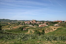
Longiano is a municipality with 7195 inhabitants (as of December 31, 2019) in the province of Forlì-Cesena in the Italian region Emilia-Romagna , about 90 km southeast of Bologna and about 30 km southeast of Forlì . The main town of the municipality lies on the first range of hills of the Apennines south of the Po Valley and is dominated by the "Rocca Malatestiana" castle complex from the 13th and 14th centuries. Part of the municipality is on the plain and touches State Road 9 , where numerous industrial companies have settled.
The municipality includes the districts of Badia, Balignano, Budrio, Crocetta, Felloniche, Massa, Montilgallo and Ponte Ospedaletto.
Bordering municipalities are Borghi , Cesena , Gambettola , Gatteo , Montiano , Roncofreddo , Santarcangelo di Romagna and Savignano sul Rubicone .
Individual evidence
- ↑ Statistiche demografiche ISTAT. Monthly population statistics of the Istituto Nazionale di Statistica , as of December 31 of 2019.

