Maca District
| Maca District | |
|---|---|
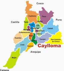
 The Maca District (marked in brown) is centrally located in the Caylloma Province |
|
| Basic data | |
| Country | Peru |
| region | Arequipa |
| province | Caylloma |
| Seat | Maca |
| surface | 237 km² |
| Residents | 701 (2017) |
| density | 3 inhabitants per km² |
| ISO 3166-2 | PE-ARE |
| politics | |
| Alcalde District | Sixto Indalecio Rosas Pari (2019-2022) |
| Political party | Arequipa Renace |
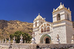
| Iglesia de Santa Ana de Maca | |
Coordinates: 15 ° 38 ′ S , 71 ° 46 ′ W
The Maca District is located in the Caylloma Province in the Arequipa region in southwestern Peru . The district has an area of 237 km². The 2017 census counted 701 inhabitants. In 1993 the population was 1182, in 2007 it was 916. The district administration is located in the 3262 m high village of Maca with 691 inhabitants (as of 2017). It is the only town in the district.
Geographical location
The Maca district is located 18 km west of the provincial capital Chivay in the center of the Caylloma province. It has a length in north-south direction of 23 km and a width of 7.5 km. The district is located on the south bank of the west flowing Río Colca . Agriculture is practiced on terraces above the Colca Valley . There are several lookout points that overlook the gorge. These are frequented by tourists. The mountains in the south of the district are dry and barren. In the south-west of the district rise the extinct volcanoes Hualca Hualca ( 6025 m ) and Sabancaya ( 5976 m ).
The Maca district is bordered on the southwest by the district Lluta , in the northwest on the district Cabanaconde , on the north by the district Lari and the east by the district Achoma .
Individual evidence
- ↑ a b PERU: Arequipa region - provinces and districts . www.citypopulation.de. Retrieved May 7, 2020.
