Malika (Pikine)
| Malika Commune d'arrondissement Malika |
|
|---|---|
| Coordinates | 14 ° 47 '58 " N , 17 ° 20' 13" W |
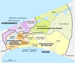
 The 16 communes d'arrondissement in Pikine The 16 communes d'arrondissement in Pikine
|
|
| Basic data | |
| Country | Senegal |
| Dakar | |
| Department | Pikins |
| ISO 3166-2 | SN-DK |
| Arrondissement | Arrondissement des Niayes |
| height | 7 m |
| surface | 9 km² |
| Residents | 32,130 (2013) |
| density | 3570 Ew. / km² |
Malika is one of the 16 districts (Communes d'arrondissement du Sénégal) of Pikine , the largest city in Senegal even before the capital Dakar . In the Arab world of North Africa, Malika is a feminine given name meaning queen .
geography
Malika is located in the northeast of the bottle neck of the Cap-Vert Peninsula . The municipality stretches almost six kilometers long with a width of 1000 to 2400 meters between the sandy beach of the Grande-Côte in the north and the lakes Lac Wouye in the southwest (including) and Lac Mbeubeuss in the southeast (exclusively). This means that the lake basin known as décharge de Mbeubeuss and serving as the central garbage dump of the Dakar metropolitan region lies just outside the district boundaries. In the south, the residential areas of the city district include the northern third of the hexagonal honeycomb area of the Cité Sonatel .
The municipality has an area of 9.0 km². The borderline results from a satellite photo released in 2019 as part of an official documentation. Neighboring counter-clockwise are the districts of Yeumbeul North in the southwest, Keur Massar in the southeast and in the northeast across the border to the Rufisque department, the rural community of Tivaouane Peulh-Niaga .
population
The last censuses showed the following population figures for the city district:
| year | Residents |
|---|---|
| 1988 | ... |
| 2002 | 14 167 |
| 2013 | 32 130 |
traffic
Malika is located north of the traffic axes of the Cap-Vert Peninsula, on which the west-east traffic flows between the metropolis Dakar and the rest of the country. This traffic is served by the national road N 1 and the Dakar – Niger railway line , and with junction 8 of the toll Autoroute 1 , the city district has a fast connection to the west with the capital Dakar and to the east with the new Dakar-Blaise Diagne international airport .
In Malika itself, the Route de Malika serves as the main traffic axis. It leads from Gare de Thiaroye in a north-easterly direction through Yeumbeul Sud and Yeumbeul Nord and makes a curve to the south-east in Malika and leads over Keur Massar to Rufisque Ouest . Parallel to the beach on the Atlantic coast, the four-lane expressway Voie de Dégagement Nord (VDN) connects the district to the west with Guédiawaye and via Cambérène , where construction work is being delayed, with downtown Dakar.
Individual evidence
- ↑ Lac Wouye at Geonames
- ↑ Lac Mbeubeuss at Geonames
- ↑ Singaravélou, Comité national français de geographie. Commission "Espaces tropicaux et leur développement" - 1997: La décharge de Mbeubeuss , p. 493 in the Google book search
- ↑ Estimation of the population of Dakar par collectivité locale en 2004 Area of the city districts on page 166 of the PDF file 1.12 MB
- ^ Agence nationale de l'Aménagement du Territoire (ANAT), December 20, 2019: Missions de démarcation de communes. Jaxaay-Parcelles Assainies-Niakoul Rab / Mbao / Keur Massar / Rufisque Ouest / Tivaouane Peul-Niaga
- ^ Boundary course in the satellite photo ( Memento from January 6, 2020 in the Internet Archive )
- ↑ Program de gestion des déchets des déchets solid urbains de la région de Dakar, annual report 2016 Municipal boundaries of the metropolitan region of Dakar see page 30 of the 3.84 MB PDF file
- ↑ ANSD: Résultats préliminaires du Troisième Recensement Général de la Population et de l'Habitat du Sénégal de 2002 (RGPH-III) ( Memento of September 28, 2007 in the Internet Archive ) City districts of Pikine with statistics on their population Page 9 of the PDF File 1.64 MB
- ↑ ANSD: Rapport Projection de la Population du Senegal 2013–2063 (RGPHAE 2013) Figures for 2013, pages 21–22 of the PDF file 1.44 MB