Malkomes
|
Malkomes
Community of Schenklengsfeld
Coordinates: 50 ° 51 ′ 8 ″ N , 9 ° 49 ′ 13 ″ E
|
|
|---|---|
| Height : | 255–285 m above sea level NHN |
| Area : | 1.7 km² |
| Residents : | 217 (Dec. 31, 2017) |
| Population density : | 128 inhabitants / km² |
| Incorporation : | December 31, 1971 |
| Postal code : | 36277 |
| Area code : | 06629 |
|
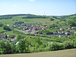
Malkomes from the slope of the Birkig. In the background the Mühlberg.
|
|
Malkomes is a district of the municipality of Schenklengsfeld in the Hersfeld-Rotenburg district in East Hesse .
geography
The place is north-northwest of the main town Schenklengsfeld. The Solz flows through Malkomes and flows into the Fulda in Bad Hersfeld . The next larger city is Bad Hersfeld, about nine kilometers away. One kilometer before Malkomes branches from the Federal Highway 62 , the main road 3171 off. It crosses the town and after five kilometers reaches Schenklengsfeld.
history
Malkomes was first mentioned in writing on January 2, 1340 as belonging to the Propstei Petersberg under the place name Malkandis . This name changed several times in the following centuries, via Malkes, Malckmus and to Alckmas . In 1585 he was called Malkemes and belongs to the parish of Schenklengsfeld. The locals call it Maalkemes in dialect . The stress is on the first syllable. The " o " was only added to the name after 1826.
On December 31, 1971, Malkomes was incorporated into the community of Schenklengsfeld.
chapel
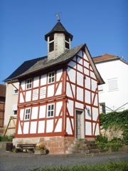
The small half-timbered - chapel was built in 1734 and has a floor plan of 5 x 4.3 meters. It was last completely renovated in 2012.
In two compartments on the front is the following inscription:
"Brought down in World War Storm, sounds new bell from the tower!"
"Come all! calls the bell sound. Praise God on his throne! "
Infrastructure
Public facilities
There is a village community center in the village . In the annex is the accommodation of the Malkomes / Schenksolz and Dinkelrode volunteer fire brigade . Local public transport is carried out by ÜWAG Bus GmbH with line 340.
Solztalradweg
On the old railway line of the Hersfelder circular path of the light coming from Bad Hersfeld extends Solztalradweg until after Schenklengsfeld. After the cessation of rail traffic on December 31, 1993, the disused route quickly became overgrown . In the summer of 1999 the tracks between Bad Hersfeld and Schenklengsfeld were dismantled. From Schenksolz to Lampertsfeld , the community of Schenklengsfeld provisionally built a section with limestone gravel. In 2003 the route was paved. On October 4th, 2003 the Solztalradweg was inaugurated in Schenksolz. An approximately 1100 meter long section from Malkomes to the Solzbrücke in the village was only completed in summer 2008. For almost five years you had to bypass this via a farm road. Now the Solztal cycle path from Bad Hersfeld train station is paved all the way to Schenklengsfeld. Since it was a former railway line, the gradient of the entire route towards Schenklengsfeld is very low.
It is very popular not only with cyclists, inline skaters and skateboarders, but also with joggers and walkers. You can all enjoy the wonderful nature of the Solztal. The former railway line used is around 15 kilometers long. Between Bad Hersfeld and Schenklengsfeld there are rest stops in Gut Oberrode, Sorga, Malkomes, Schenksolz and Lampertsfeld.
The Solztal Cycle Path is now part of the Hessen Railway Cycle Path . This leads from Hanau on former railway lines about 250 kilometers through the Vogelsberg and the Rhön and ends in Bad Hersfeld.
Web links
- Malkomes district. In: Internet presence. Community of Schenklengsfeld
- Malkomes. Local history, information. In: www.schenklengsfeld.info. Private website , archived from the original on October 26, 2016 .
- Malkomes. Local history, information and pictures. In: www.michael-lack.de. Private website
- Malkomes, Hersfeld-Rotenburg district. Historical local dictionary for Hessen. In: Landesgeschichtliches Informationssystem Hessen (LAGIS).
- Literature on Malkomes in the Hessian Bibliography
Individual evidence
- ^ Malkomes, Hersfeld-Rotenburg district. Historical local dictionary for Hessen. (As of November 20, 2015). In: Landesgeschichtliches Informationssystem Hessen (LAGIS).
- ↑ Figures, data & facts on the website of the community of Schenklengsfeld , accessed in August 2018
- ^ Federal Statistical Office (ed.): Historical municipality directory for the Federal Republic of Germany. Name, border and key number changes in municipalities, counties and administrative districts from May 27, 1970 to December 31, 1982 . W. Kohlhammer GmbH, Stuttgart and Mainz 1983, ISBN 3-17-003263-1 , p. 396 .
- ↑ Two weirs - one powerful unit. In: Hersfelder Zeitung of January 20, 2015, accessed on May 10, 2015.


