Wippershain
|
Wippershain
Community of Schenklengsfeld
Coordinates: 50 ° 49 ′ 56 ″ N , 9 ° 46 ′ 17 ″ E
|
|
|---|---|
| Height : | 414 m above sea level NHN |
| Area : | 8.26 km² |
| Residents : | 624 (December 31, 2017) |
| Population density : | 76 inhabitants / km² |
| Incorporation : | August 1, 1972 |
| Postal code : | 36277 |
| Area code : | 06621 |
|
View over Wippershain in the Kuppenrhön
|
|
Wippershain is a district of the community Schenklengsfeld in the eastern Hessian district of Hersfeld-Rotenburg . Measured by the number of inhabitants, the place is the second largest district of Schenklengsfeld after the core municipality.
geography
The village is located about 6.2 kilometers west of the core community and about 7 km southeast of Bad Hersfeld . In the local area lies the source of the Wüllersbach, which drains into the Haune via the Fischbach and the Eitra .
The place is on the southern slope of the Wippershainer Höhe. Its highest point of 456 meters is only about 600 meters north of the village. Towards the south and south-east, the terrain slopes slightly towards the Kuppenrhön plateau and the Hessian skittles . In a westerly direction the land drops into the lower Haunetal.
history
The place was first mentioned in 1317 as "Wyprechteshain". The place was later called "Wypersheim" and from the 16th century the current name prevailed. It is believed that the place was named after Saint Wigbert, who was buried in the nearby Hersfeld Monastery. The location on the Altstrasse , on which the pilgrims came to the holy grave in Hersfeld, may have contributed to this. The Höhenstraße was called “Karlsstraße” in this section because Charlemagne is said to have traveled on from the Weser to Würzburg .
The town center, which was mentioned in 1317, was probably a little further to the east, in today's Gewann Heckengarten. As early as 1494 the place was called a desert . The resettlement took place in today's local area, which lies a little further into the valley of the Wüllersbach.
The place belonged to the small court of Hersfeld Schildschlag ("Schildislo"), which was formed in the 13th century from the south-western parts of the imperial Eherinevirst donation from 1003. The court was always managed during its existence from neighboring offices, had therefore never a private bailiff or a court facility. For a long time the Lords of Buchenau had the court of Hersfeld Abbot as a fief . In the 14th, 15th and 16th centuries, the court and with it Wippershain often changed its fiefdoms. In addition to the Buchenau, these were the Johannesberg provost and Landgrave Wilhelm II of Hesse . During this time, Wippershain was therefore administered from Buchenau in the south , from Johannesberg in Hersfeld or from Hauneck in Hesse , where the courts were located in each case. When the imperial abbey went legally binding to the Landgraviate of Hessen-Kassel in 1648 , the feudal lordship also passed to the Landgraves. The village remained in fiefdom of the Buchenau family. Wippershain only became completely Hessian between 1720 and 1722, when the Landgrave of Hessen-Kassel bought the Buchenau fiefdom. Then the Schildschlag court was dissolved and Wippershain was assigned to the Hessian office of Hauneck , based in Holzheim . With the Hessian district order of June 29, 1821, the old courts and offices were dissolved and replaced by districts. Since then, Wippershain has been a municipality in the Hersfeld district .
On August 1, 1972, Wippershain was incorporated into the community of Schenklengsfeld as part of the regional reform in Hesse .
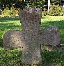
Border or atonement cross
On the 3rd street, directly on Kreisstraße 17, there is a sandstone cross in the form of a Maltese cross . It was mentioned in a description of the border between the Schildschlag and Landeck offices on November 3, 1531, as the border between the Schildschlag court and the Landeck office was located there. Over time, the cross sank into the earth and was forgotten. It was only found again in 1911 and placed at the original location by the forester. In the early 1980s, the county road was renewed and the cross moved a few meters to its current location.
In view of the above mentioned documentary evidence, it is reasonable to assume that it is a border cross. However, since there are no corresponding traditions, it can also be an atonement cross.
Population development
Source: Historical local dictionary
| • 1631: | 37 households |
| • 1747: | 38 households |
| Wippershain: Population from 1834 to 2017 | ||||
|---|---|---|---|---|
| year | Residents | |||
| 1834 | 392 | |||
| 1840 | 424 | |||
| 1846 | 435 | |||
| 1852 | 448 | |||
| 1858 | 424 | |||
| 1864 | 391 | |||
| 1871 | 350 | |||
| 1875 | 339 | |||
| 1885 | 315 | |||
| 1895 | 350 | |||
| 1905 | 391 | |||
| 1910 | 367 | |||
| 1925 | 358 | |||
| 1939 | 344 | |||
| 1946 | 459 | |||
| 1950 | 422 | |||
| 1956 | 392 | |||
| 1961 | 379 | |||
| 1967 | 421 | |||
| 1970 | 430 | |||
| 2001 | 686 | |||
| 2006 | 709 | |||
| 2009 | 665 | |||
| 2017 | 624 | |||
| Data source: Historical municipality register for Hesse: The population of the municipalities from 1834 to 1967. Wiesbaden: Hessisches Statistisches Landesamt, 1968. Further sources:; Community of Schenklengsfeld | ||||
Religious affiliation
Source: Historical local dictionary
| • 1885: | 315 Protestant (= 100.00%) residents |
| • 1961: | 349 Protestant (= 92.08%), 24 Catholic (= 6.33%) residents |
religion
The largest building in the office has probably always been a church in Wippershain, which was destroyed by Croatian troops in the Thirty Years' War in 1634. After petitions to the sovereigns in Kassel , the church was rebuilt in 1680 and a reformed pastor was appointed. The church was rebuilt in 1783 in the style of the time; further redesigns took place between 1953 and 1955.
Half a parish office has been set up in the Protestant parish, which has around 550 parishioners. The parish has a parish hall and runs a kindergarten with a group. The parish supports a children and youth choir.
Culture and sights
Flight model
In 2011 the first Lego model airplane of an Airbus A380 was built in Wippershain . It was produced in 300 working hours by the Wippershain dental technician Nils Hartwig. The model is currently on loan in a showcase at Frankfurt Airport .
societies
Together with the neighboring village of Rotensee and the town of Schenklengsfeld, there is the SG Rotensee / Wippershain / Schenklengsfeld football club. The club's sports field is located at the highest point of the Wippershainer Höhe. In the popular sports association 1989 Wippershain e. V. there are other sports groups.
There is also the Wippershain volunteer fire brigade , the fair boys and various choirs.
Economy and Infrastructure
There is a village community center in the village.
traffic
The village can be reached via Kreisstraße 17, which leads from Bad Hersfeld to the Schenklengsfeld district of Wüstfeld . Both Kreisstraße 76 (13th street) and 3rd street lead from K17 into the village. Local public transport is carried out by ÜWAG Bus GmbH with line 345.
A special feature in Wippershain is that there are only numbered street names (see also under ideal city ). The streets with the numbers 3, 7, 9, 10, 11 and 13 lead from northeast to southwest, those with the numbers 6, 8 and 12 from southeast to northwest (3 and 6 from the numbering in the opposite direction). Other streets have numbers that are derived from the streets from which they branch off, for example 71st street runs from 7th to 9th street, 91st street runs almost parallel to 9th street. Two streets running across 10th, 11th and 13th streets have a different name on each section, corresponding to the cross street running directly south, i.e. 101./111./131. Street and 102./112./132. Street. 113th, 114th and 115th streets deviate from this system. This results in 20 street names for the place.
Usable space
The 3.52 km² that belong to the village are divided as follows (as of 2001):
- Courtyard and building area: 21.84 ha
- Traffic area: 31.73 ha
- Agricultural area: 255.88 ha
- Water surface: 1.75 ha
- Forestry area: 39.99 ha
- Other areas: 1.44 ha
Transmission towers
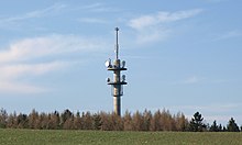
The transmitter Wippershainer Höhe is located about 1.3 kilometers north of Wippershain, near Bad Hersfeld at 454 m above sea level. NN . Three more steel lattice towers , directly at the sports field, are used for directional radio and cell phone antennas . Furthermore, the local association F 69 Bad Hersfeld of the German Amateur Radio Club e. V. (DARC) these towers for its relay station , the repeater and the digipeater .
Personalities
One son of the community was the Nazi functionary, legation councilor and economic manager Gerhard Kreuzwendedich Todenhöfer (1913–1973).
literature
- Elisabeth Ziegler: The territory of the imperial abbey of Hersfeld from its beginnings to 1821. NG Elwert'sche Buchhandlung, Marburg 1939, pp. 115–120. (Chapter court Schildschlag )
- Literature on Wippershain in the Hessian Bibliography
Web links
- Wippershain district on the website of the community of Schenklengsfeld.
- Wippershain, Hersfeld-Rotenburg district. Historical local dictionary for Hessen. In: Landesgeschichtliches Informationssystem Hessen (LAGIS).
- Aerial view of Wippershain
Individual evidence
- ↑ a b c d e Wippershain, Hersfeld-Rotenburg district. Historical local dictionary for Hessen. (As of October 16, 2018). In: Landesgeschichtliches Informationssystem Hessen (LAGIS).
- ↑ Figures, data & facts on the website of the community of Schenklengsfeld, accessed in August 2018.
- ^ Groscurth: Villages of the district of Hersfeld. In: My homeland. January 1962, Volume 20. (Supplement to the Hersfelder Zeitung )
- ↑ Law on the reorganization of the districts of Hersfeld and Rotenburg (GVBl. II 330-13) of July 11, 1972 . In: The Hessian Minister of the Interior (ed.): Law and Ordinance Gazette for the State of Hesse . 1972 No. 17 , p. 217 , § 11 ( online at the information system of the Hessian state parliament [PDF; 1,2 MB ]).
- ^ Federal Statistical Office (ed.): Historical municipality directory for the Federal Republic of Germany. Name, border and key number changes in municipalities, counties and administrative districts from May 27, 1970 to December 31, 1982 . W. Kohlhammer, Stuttgart / Mainz 1983, ISBN 3-17-003263-1 , p. 397 .
- ^ Heinrich Riebeling: Stone crosses and cross stones in Hessen. Werner Noltemeyer Verlag, Dossenheim / Heidelberg 1977, ISBN 3-88172-005-7 .
- ↑ A dream came true: Nils Hartwig handed Flieger over to Fraport. on: osthessen-news.de , April 30, 2011.


