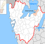
Mariestad (Municipality)
| Mariestad municipality | |||||
|---|---|---|---|---|---|
|
|||||
| State : | Sweden | ||||
| Province (län): | Västra Götalands län | ||||
| Historical Province (landskap): | Västergötland | ||||
| Main place: | Mariestad | ||||
| SCB code: | 1493 | ||||
| Residents : | 24,537 (December 31, 2019) | ||||
| Area : | 1,503.2 km² (January 1, 2016) | ||||
| Population density : | 16.3 inhabitants / km² | ||||
| Website : | www.mariestad.se | ||||
| List of municipalities in Sweden | |||||
Coordinates: 58 ° 43 ' N , 13 ° 49' E
Mariestad is a municipality ( Swedish kommun ) at the lake Vänern in the southern Swedish province of County of Västra Götaland and the historical province of Västergötland . The main town of the municipality is Mariestad .
geography
The municipality extends about 40 kilometers along the eastern bank of the Vänern. The offshore archipelago and islands also belong to the municipality . a. the Djurö archipelago , which has been a national park since 1991.
In the north of the municipality is Sjötorp (about 20 km north of Mariestad), where the Göta Canal flows into the Vänern.
In the south, the municipality has a share in the mountain Lugnåsberget with the village Lugnås (10 km southwest of Mariestad), formerly an important producer of millstones, whose quarries can now be visited. East of Lugnåsberget extends the valley of the Tidan , which flows here from the Östen bird lake to Vänern, into which it flows at Mariestad.
history
economy
The largest employer in the community is the public sector. The industry is concentrated in the city of Mariestad (see there).
places
The following places are localities ( tatorter ):
Web links
swell
- ↑ Folkmängd i riket, län och kommuner December 31, 2019 at Statistiska centralbyrån
- ↑ Kommunarealer January 1, 2016 at Statistiska centralbyrån (including all inland waters)

