Martinistrasse (Bremen)
| Martinistrasse | |
|---|---|
| Street in Bremen | |
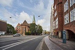
| Martinistraße towards Am Brill with Martini Church and Robinson Crusoe House , House Atlantis | |
| Basic data | |
| city | Bremen |
| district | center |
| Created | 11th century |
| Cross streets | Behind the wooden gate, Stavendamm, Balgebrückst., Wilhelm-Kaisen-Brücke , Wachtstrasse, Böttcherstrasse , Bredenstrasse, Erste Schlachtpforte, Martiniplatz, Ulenstein, Second Schlachtpforte, Langenstr. , Pieperstr., Heimlichenstr., Short Pilgrimage, Bürgermeister-Smidt-Str. , Am Brill |
| Buildings | Martinikirche , Bötcherstraßenbauten, House of the Handelskrankenkasse , Schünemannhaus, Pressehaus |
| use | |
| User groups | Cars, bikes and pedestrians |
| Road design | four lane road |
| Technical specifications | |
| Street length | 800 meters |


The Martinistraße is partly a historical street in Bremen in the district center in the old town. It leads in an east-west direction from the Tiefer to Am Brill and Faulenstrasse .
The cross streets were named as Hinter der Holzpforte after the wooden gate on the Weser in the Bremen city wall , Stavendamm after Stave = room, as there were bathing rooms for the crew of the ships, Balgebrückstraße after a small bridge over the bellows from the wooden gate to the Schlachte , Wilhelm-Kaisen-Brücke after Mayor Wilhelm Kaisen , Wachtstraße after a guard at the bridge gate, which existed until 1839, Böttcherstraße , where the Böttcher , Kimker , Fass - and Zubermacher were based, Bredenstraße (1360) because at that time it was a wide (brede) Street was, first battle gate after a gate in the city wall, Martini square after the church, Ulenstein to Ul = pot, here the potters sold their goods delivered by boat, second battle gate, s. o., Langenstraße (1234 the longa platea ) due to its length, Pieperstraße after the town musicians who lived here, Heimlichenstraße after a secret path that was used when the gates were closed at night, Short pilgrimage after their use in bad weather, abbreviated Corpus Christi processions , Bürgermeister-Smidt-Straße after Mayor Johann Smidt , Am Brill after a gate (up to the 16th century) in the Bremen city wall; otherwise see link to the streets.
history
Surname
The street was named after the St. Martini Church , the Sunte Marten from the 13th century for the parish from 1229. The late Gothic brick building suffered severe damage in 1944 and was rebuilt after the war. For centuries it was considered the church of the merchants, the Ollermannskarken after the older people of the merchants .
development
In the 13th century, Bremen was divided into four parishes: Liebfrauen, Stephani, Ansgarii and Martini. The Martini community was first mentioned in a document in 1229
Martinistraße was a street that in the Middle Ages led from Wachtstraße / Tiefer past the Martinikirche to the second battle gate and ended in front of a packing house. The extension to Brill took place after 1961.
Martini breakthrough
During the Second World War , many houses in the area around what is now Martinistraße were destroyed in 1944. When rebuilding, the city wanted to use this fact to rearrange the traffic. The Bremen market square should be bypassed. In autumn 1944, the then building director Wilhelm Wortmann u. a. the Martini breakthrough. In November 1945, the building authorities presented a city-wide transport route plan with the Martini breakthrough. In May 1949, the Bremen citizenship decided on a traffic route plan for the old town, in which the traffic away from the market square should be routed via Martinistraße, Pieperstraße, Papenstraße, beinhauerstraße , Schüsselkorb , Violenstraße and Balgebrückstraße (Kleiner Ring). A large tangent square was intended for long-distance traffic ( Breitenweg , route through Mozartstrasse, Neuenlander Strasse , Oldenburger Strasse / B75, prevented by groups of citizens and not implemented ).
In 1951 the architects Arthur Bothe and Rolf Störmer, together with the city planning office, presented a plan for a new, expanded Martinistraße with a street width of 18 meters. After the breakthrough in the road on the Bürgermeister-Smidt-Strasse (formerly Kaiserstrasse) in 1875, this was the second significant road breakthrough in Bremen-Mitte. Development plans for this were decided in 1953/1955. During the Martini breakthrough, several old streets were interrupted or they disappeared (including Whey, Mustard, Starch, Heeren, Schmiede- and Wilkenstraße). The diagonally crossing course of the historic Langenstrasse was severely disturbed. A lower elevation of Martinistraße at this point and an alternative street course on the Schlachte, proposed by Hermann Struss in 1949, were not discussed further. A planned relocation of the tram from Obernstraße to Martinistraße was not pursued either. The extension was realized from October 1961 to May 1962 and completed in 1968 after the now closed Am Brill pedestrian tunnel.
traffic
The Bremen tram runs parallel to lines 2 and 3 in the nearby Obernstrasse and it crosses Am Brill with line 1 and at Wilhelm-Kaisen-Brücke with lines 4, 6 and 8.
In local transport in Bremen , the bus line 25 runs on Martinistraße (Weidedamm-Süd - Utbremer Ring - Am Brill - Domsheide - Hauptbahnhof - Julius-Brecht-Allee - Osterholz).
Buildings and facilities
There are four to twelve story buildings on the street.
Architectural monuments
- Martinikirchhof 3: St. Martini Church ( Sunte Marten ) from the 13th century
- No. 17: 4-sch. House Atlantis at the end of Böttcherstraße from 1931 based on designs by Bernhard Hoetger
- No. 19: 4-sch. Robinson Crusoe House at the end of Böttcherstraße from 1931 based on plans by Ludwig Roselius , Alfred Runge and Eduard Scotland , Bremen
- No. 27 : 5-sch. Residential and office building from 1750 according to plans by Theophilus Wilhelm Frese (lower facade: baroque and rococo ) or 1965 as reconstruction
- No. 26: 3-storey office and residential building with two gables of the German Steamship Company "Hansa" from 1914 by the architects Heinrich Behrens & Friedrich Neumark . Reconstruction from 1950 by the architects Heinrich Wilhelm Behrens, old gable (Martinistraße) from around 1570 and 1630, portal (Schlachte 6) from 1601/10. Since 1981: House of the Handelskrankenkasse
- No. 28: 5-sch. Office building (ex. Publishing house as Schünemannhaus) from 1927 according to plans by Carl Rotermund in the Schlachte ensemble
- Langenstrasse 28 / corner Martinstrasse: 3-storey. Kontorhaus Suding und Soeken from around 1620/30 in the Renaissance style , renovated in 1902
Other buildings and facilities
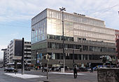
- No. 1 / corner of Wachtstraße: 6-gesch. Business and office building of the Bremen Bank Association from 1978 based on plans by Theodor and Klaus Rosenbusch
- Wilhelm Kaisen Bridge from 1960
- Wilhelm-Kaisen-Brücke 1: From 1910 to 1944: Headquarters of the so-called Kappfsche "Burg" by Ludwig von Kapff ; from 1962 to 2017: 4- or 10-st. August Kuehne House of the freight forwarding company Kuehne + Nagel based on plans by Cäsar Pinnau from Hamburg; since 2017 5 or 12 times Significantly larger new building of the August-Kühne-Haus based on plans by MPP Meding Plan , Hamburg.
- No. 5/6 formerly an office building of the CH Haake company, converted in 1911 according to plans by Otto Blendermann
- No. 8-12: 5-sch. Commercial and residential building
- No. 16: 5-sch. hotel
- No. 24: 5-sch. Office building as Albingahaus (an insurance company) based on plans by Peter Ahlers, Bremen
- No. 27: 5-sch. Hotel from 2017
- Martini place
- No. 30: 6-gesch. Business and office building of ÖVB Versicherungen ( VGH-Versicherung ) from 1986 based on plans by Horst Rosengart , Bremen
- No. 34 previously: Packhouse of the wine and spirits company Joh.Eggers Sohn from 1840
- No. 43: 6- / 7-sch. Weser-Kurier press house from 1957 based on plans by Richard Schepke, Kassel
- Langenstrasse No. 13: BREPARKhaus press building from around 2010 with 660 parking spaces
- No. 48 / corner of Langenstrasse: 9-gesch. Office building
- No. 57: 6-gesch. Business and office building from 1967 based on plans by Gerhard Müller-Menckens , Bremen
- No. 72 / corner of Bürgermeister-Smidt-Straße and Am Brill: 6-gesch. Office building as the Zurich house of Zurich Insurance from 1995 according to plans by Gert Schulze , Bremen
- At the corner of Bill and Martinistraße: 7-storey Brillissimo department store and commercial building from 2010 based on plans by Grüntuch Ernst Architects , Berlin
Monuments, fountains
- No. 26: Bronze eagle on a stone plinth from 1971 by sculptor Hans Wimmer, Munich; it should symbolize immortality, courage, vision and strength
- Martinistraße / corner Balgebrückstraße: Kinetic object in Bremen from 1973 made of stainless steel on a concrete base by the Berlin sculptor Hein Sinken
- At the Neanderhaus next to the Martinikirche: Jakobusbrunnen from 1957 as a modified replica of the destroyed original from 1718
- Martinistraße / Pieperstraße: Gezeitenbrunnen (Bremen) from 1992 by the object artist Wolfgang Zach
See also
literature
- Herbert Black Forest : The Great Bremen Lexicon . 2nd, expanded and updated edition. In two volumes. Edition Temmen, Bremen 2003, ISBN 3-86108-693-X (first edition: 2002, supplementary volume A – Z. 2008, ISBN 978-3-86108-986-5 ).
- Monika Porsch: Bremer Straßenlexikon , complete edition. Schünemann, Bremen 2003, ISBN 3-7961-1850-X .
- Hans Hermann Meyer: The Bremen old town. Edition Temmen , Bremen 2003, ISBN 3-86108-686-7 .
- Eberhard Syring: Bremen and its buildings - 1950 - 1979 . Schünemann Verlag, Bremen 2014, ISBN 978-3-944552-30-9 .
Individual evidence
- ↑ Frank Hethey: A path through the Aitstadt. In: Bremen History , 2015.
- ↑ 1620 according to monument preservation, 1630 according to Stein in Das Bürgerhaus in Bremen , p. 30:
- ↑ Pascal Faltermann: Demolition for a 26 million euro new building has begun . IN: Weser-Kurier from January 5, 2017.
Coordinates: 53 ° 4 ′ 34 " N , 8 ° 48 ′ 15" E


