Matulji
| Matulji | ||
|
||
|
|
||
| Basic data | ||
|---|---|---|
| State : |
|
|
| County : |
|
|
| Height : | 180 m. i. J. | |
| Area : | 175.6 km² | |
| Residents : | 11,246 (2011) | |
| Population density : | 64 inhabitants per km² | |
| Telephone code : | (+385) 051 | |
| Postal code : | 51211 | |
| License plate : | RI | |
| Structure and administration (status: 2013, cf. ) |
||
| Community type : | local community | |
| Mayor : | Mario Ćiković ( SDP ) | |
| Coalition partner : | HNS, HSU, IDS | |
| Website : | ||
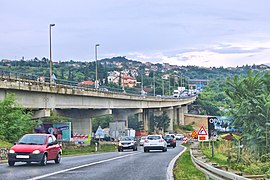
 View of Matulji |
||
Matulji (ital. Mattuglie ) is a municipality in the Primorje-Gorski kotar County , Croatia , about 13 km northwest of Rijeka .
Since Abbazia (now Opatija ) was expanded by the Austrian Southern Railway Company, Matulji has served as a train station for the seaside resort. Until the 1930s there was even an electric tram from Matulji to the holiday resorts of the Kvarner Bay , with its terminus in Lovran ; The concessionaire was the building contractor Jakob Ludwig Münz from 1908–1933 .
The landmark of the place is the Christ the King's Church. It was built in the historicist style in 1834. Tourism plays an important economic role. People are promoting hiking on the slopes of the Učka and Líšina , visiting the medieval towns of Kastav and Veprinac and swimming in Opatija and in the Preluk bay. The carnival in January / February with its Perchten procession , which gathers mask dancers from all over the region, is a special attraction .

