Mošćenička Draga
| Mošćenička Draga | ||
|
||
|
|
||
| Basic data | ||
|---|---|---|
| State : |
|
|
| County : |
|
|
| Area : | 43.94 km² | |
| Residents : | 1,535 (2011) | |
| Population density : | 35 inhabitants per km² | |
| Telephone code : | (+385) 051 | |
| Postal code : | 51417 | |
| License plate : | RI | |
| Boat registration : | MD | |
| Structure and administration (as of 2017) |
||
| Community type : | local community | |
| Mayor : | Rikardo Staraj (free) | |
| Website : | ||
| Others | ||
| Patron saint : | Holy Marina | |
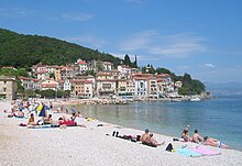
 Mošćenička Draga - port |
||
Mošćenička Draga (ital. Draga di Moschiena ) is a tourist municipality in the Primorje-Gorski kotar County on the Istrian peninsula in Croatia .
geography
The municipality has 1,535 inhabitants (2011 census) and an area of 43.94 km². The area of the place on the Kvarner Bay extends into the Croatian Učka Nature Park . It consists of the 14 villages Brseč , Golovik, Grabrova, Kalac, Kraj, Mala Učka, Martina, Mošćenice , Mošćenička Draga, Obrš, Sučići, Sv. Anton, Sv.Jelena and Zagore.
history
The mountain towns of Brseč and Mošćenice emerged on the tops of hills in the 12th and 13th centuries and, together with Veprinac and Kastav, formed a chain of fortresses along the east coast of Istria. They served as a refuge for the coastal residents.
economy
The main economic sectors have been fishing since the 19th century and tourism since the end of the Second World War. The municipality offers around 2,500 beds for tourists, around 1,100 of which are in hotels and on campsites, around 1,400 in private accommodation.
Web links
- Information page of the Moščenićka Draga tourist center at tz-moscenicka.hr (German), accessed on July 17, 2019.
Individual evidence
- ↑ O Mošćeničkoj Dragi on moscenicka-draga.hr (Croatian), accessed on July 17, 2019.
- ↑ Information on the website of the Mošćenićka Draga tourist center


