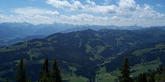
Group of horns
| Group of horns | |
|---|---|
|
Large arch of the group of horns from the Steineberg ( Nagelfluhkette ); in the middle the Gunzesried valley; on the left the Ofterschwanger Horn , on the far right the Riedberger Horn ; in the background the main ridge of the Allgäu Alps |
|
| Highest peak | Riedberger Horn ( 1787 m ) |
| location | District of Oberallgäu , Bavaria |
| part of | Allgäu Alps |
| Coordinates | 47 ° 27 ' N , 10 ° 11' E |
| particularities | Natura 2000 area , landscape protection area , nature park |
The horn group is a close fishing in the Allgäu , up to 1787 m above sea level. NN high summit group of the Allgäu Alps in the Oberallgäu district , Bavaria ( Germany ). It is part of the Nagelfluhkette Nature Park .
geography
Geographical location
The Hörnergruppe is located in the western part of the Allgäu Alps west of the Illertal , where Sonthofen is in the northeast, Fischen im Allgäu in the east and Oberstdorf in the southeast. The B 19 leads past eastwards , from which you can turn west onto the OA 9 district road from Fischen im Allgäu through Obermaiselstein , over the Riedbergpass and through Balderschwang to Hittisau in Austria . The Nagelfluhkette is located north of the horn group .
Horned Villages
The communities Balderschwang , Bolsterlang , Fischen im Allgäu , Obermaiselstein and Ofterschwang at the foot of the Hörnergruppe market themselves as "the Hörnerdörfer", between them there is an administrative association, the administrative association Hörnergruppe .
mountains
The group of horns is made up of the mountains - height in meters above sea level (NN):
|
|
Flowing waters
The rivers with their estuary in and on the edge of the horn group include:
|
|
Protected areas
The Hörnergruppe is designated as a landscape protection area Hörnergruppe ( LSG-00467.01 ) with 6,811.2 ha. This includes the Natura 2000 area Hörnergruppe ( DE8527301 ) according to the FFH directive with 1,183 ha.
Tourism and development
General
The horn group is open to tourists. In summer you can hike on a well-laid out and signposted “panorama path” between the horns, in winter you can go skiing and snowboarding. Skiing is possible in Grasgehren , in Bolsterlang (with the Hörnerbahn and Weiherkopfbahn ) and in Ofterschwang - Gunzesried (with the Ossi-Reichert-Bahn and World Cup Express ). The offer ranges from simple slopes at the village lift in Bolsterlang to an FIS downhill and slalom run from the Weiherkopf and a black slope in Ofterschwang, where World Cup races also take place. During the ski season, a free shuttle bus connects the ski areas in Bolsterlang and Ofterschwang.
Allgäu horn tour
Crossing several peaks of the Hörner group in winter on touring skis or on snowshoes is called the Allgäu Hörnertour , which is described in detail in special ski touring literature and which is also shown as such on corresponding maps, but is not marked in nature in winter.
In summer, the small horn tour leads from the mountain station of the World Cup Express on a panoramic path over the Ofterschwanger Horn, Sigiswanger Horn, Rangiswanger Horn and Weiherkopf to the mountain station of the Hörnerbahn or vice versa. The big horn tour also leads over the Großer Ochsenkopf, the Riedberger Horn and the Bolsterlanger Horn.
literature
- Crossing the horns . In: Josef Immler: Walk with me through the Allgäu Alps. Immenstadt 1996, 8th edition, pp. 46-48
- From Ofterschwanger to Bolsterlanger Horn - high altitude hike on the panorama path . In: Manfred Kittel: Mountain hiking with children in the Allgäu. Bruckmann Munich, 1993, pp. 139-140, ISBN 3-7654-2581-8
- Small horn tour and big horn tour . In: Uli and Dieter Seibert: Skitouren Allgäu , Steiger-Skitourenführer, Augsburg 1996, pp. 50–53. ISBN 3-89652-025-3
Individual evidence
- ↑ Green List of Landscape Protection Areas in Bavaria. (PDF; 38 kB) Bavarian State Office for the Environment, 2011, accessed on September 15, 2012 .
- ↑ SITENAME group of horns. In: Natura 2000 - Standard Data Form. European Environment Agency, accessed May 24, 2011 .
- ↑ NATUR 2000 Bavaria - Area-related concretization of the conservation objectives: horn group. (PDF; 38 kB) Bavarian State Office for the Environment, April 30, 2008, accessed on September 15, 2012 .

