Neudorf-Platendorf
|
Neudorf-Platendorf
Municipality Sassenburg
|
|
|---|---|
| Coordinates: 52 ° 32 ′ 11 ″ N , 10 ° 36 ′ 12 ″ E | |
| Height : | 54 m above sea level NN |
| Residents : | 2760 (Nov 2004) |
| Incorporation : | March 1, 1974 |
| Postal code : | 38524 |
| Area code : | 05378 |
|
Neudorf-Platendorf is part of the municipality of Sassenburg in the Gifhorn district
|
|
|
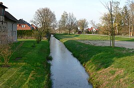
Settlement land behind Graben on the kilometer-long, dead-straight village road
|
|
Neudorf-Platendorf is a part of the municipality of Sassenburg in the Gifhorn district in Lower Saxony . Characteristic for the street village is the six kilometers long and straight village street.
geography
Geographical location
The district is east of the Ise and the Dragen State Forest. The Aller lies to the south . The district extends from southwest to northeast. In the north and east it merges into the Great Moor .
The six kilometer long village road is the longest straight through town in Lower Saxony. The bridges that connect every single property with the village street are characteristic of the townscape.
geology
The district was originally completely covered by the high moor of the Great Moor, which is now almost peated. Remnants in the north of the village have formed the approximately 2,700 hectare large moor nature reserve since the 1980s .
Neighboring places
Neighboring are the Sassenburg districts of Triangel in the south and Westerbeck in the east, the community of Wahrenholz in the north and the Gifhorn district of Gamsen in the west. The closest cities are the district town of Gifhorn and Wolfsburg .
history
The place went from the two peat New forth village and Platendorf that in 1796 on the initiative of the government of the then electorate of Hanover to the reclamation of the Great Moores had been established. In 1795 the first settler families settled in the area that belonged to the Gifhorn office and from 1885 to the Gifhorn district. A wide canal was dug near the settlement that drains the Great Moor to the north to the Aller towards the south. It was used to transport peat on ships.
Road embankments were raised on both sides along the artificial waterway. They were flanked by so-called bridging ditches. They got this name because bridges lead over them to the parcels of the "colonists" called new settlers. In contrast, the main canal did not have any crossings, as bridge constructions would have been too complex due to shipping traffic. This created the two spatially separated settlements Neu Dorf and Platendorf.
The Platendorf settlement was built along the western road embankment, and the Neudorf settlement along the eastern one. Platendorf was named after the Gifhorner Oberamtmann Plate. Each colonist was assigned a strip of land around 100 meters wide and almost a kilometer (extending to the east or west) long. Only when the central main canal was no longer needed for drainage in the 1830s was it filled with the material from the western road embankment. This strip of wasteland has been called Barwe or Berbe ever since. Since then there is only the eastern dam, which both halves of the village use as the main road. Today it is around three meters higher than the land and plots of land that the settlers have now pitted.
In 1802 there were 162 inhabitants in both places. At the beginning of the 19th century there were village expansions to the south, creating Klein Platendorf and Klein Neudorf on both sides of the canal. The settlement structure of Neudorf-Platendorf as a street village , which was created when it was founded, has been preserved to this day.
Even today there are some common family names in Neudorf-Platendorf that go back to the settlement period, for example Wulfes , Wolpers and Steinmetz .
Since March 1st 1974 Neudorf-Platendorf belongs to the municipality of Sassenburg.
In the summer of 1975 a large forest and moor fire developed north and east of the town as part of the fire in the Lüneburg Heath . The place name was part of the main news of German newspapers and television stations for days. The village itself was shrouded in clouds of smoke and was closed to residents, the fire brigade and the armed forces. However, it was possible to prevent the fire from spreading to the houses.
religion
Originally the Protestant St. Nicolai church in Gifhorn belonging village has since 1964 on the Protestant Thomas Church . For the Evangelical Free Church Community (Baptists) a church was inaugurated in 1894 and later expanded. The congregation completed its new building in 2011. The Catholic chapel Maria im Moor was built in 1929 for the residents who moved from Catholic areas and consecrated by Bishop Nikolaus Bares . Pastoral care was provided by the pastor of St. Bernward (Gifhorn) . In 1947 it was torn down again, parts of the inventory were placed in an emergency chapel in Empelde , after which it was dissolved in the Church of the Holy Family (Empelde) . Today Neudorf-Platendorf belongs to the Catholic parish of St. Altfrid (Gifhorn) .
politics
Local councilor and mayor
The following parties and constituencies have been represented in the five-member local council of Neudorf-Platendorf since the local elections:
- CDU
- SPD
- Citizens' Interest Group Sassenburg (BIG)
- List for Sassenburg (LiSa), an electoral alliance of Bündnis 90 / Die Grünen , FDP and independents
In the local elections in 2016, the CDU lost its absolute majority in the local council for the first time.
- Allocation of seats: CDU 2, SPD 1, BIG 1, LiSa 1.
Astrid Schulz (CDU) is the new local mayor .
coat of arms
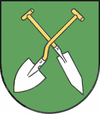
The draft emblem of Neudorf-Platendorf comes from the in Isernhagen born and later in Hannover living heraldry and crest painter peoples Gustav , who has the coat of arms of Großburgwedel , Melle village , Wunstorf and many other towns in the region Hannover has designed. The approval of the coat of arms was granted on December 16, 1950 by the Lower Saxony Minister of the Interior .
| Blazon : "In Green two different diagonally crossed, golden stalked silver Moor godfather ." | |
| Justification of the coat of arms: The coat of arms symbolizes the pioneering work that was accomplished here almost two hundred years ago. The image of the moor spade is therefore a memorial for the reclamation of the moor landscape. The variously shaped tools are a reminder that cultivated land was created here in arduous work. The green sign indicates the meadows and fields that now cover the former moorland. |
Economy and Infrastructure
The main traffic artery and local thoroughfare is the 31/1 district road , which, coming from the south on the B 188 , leads through the district in the direction of Wittingen .
Neudorf-Platendorf has a stop on the Braunschweig – Wieren railway line . The branch line of the Deutsche Bahn runs past the place to the west. The train service on the branch line has been operated by Erixx since December 2014 .
The stop will no longer be served by the next timetable change from December 13, 2020.
literature
- The district of Gifhorn . The districts in Lower Saxony, vol. 26. Ed. By Lower Saxony State Administration Office, Bremen 1972, ISBN 3-87172-327-4 .
- Cornelia Thömmes-Wittig: Colonies. In: Historic buildings in the Gifhorn-Wolfsburg area. Gifhorn 1992
- Karsten Eggeling: Neudorf-Platendorf and the "Great Moor" . Sassenburg 1996.
- Hermann Schrader: Neudorf-Platendorf relived in pictures . Gifhorn 1998.
Web links
Individual evidence
- ^ Federal Statistical Office (ed.): Historical municipality directory for the Federal Republic of Germany. Name, border and key number changes in municipalities, counties and administrative districts from May 27, 1970 to December 31, 1982 . W. Kohlhammer GmbH, Stuttgart / Mainz 1983, ISBN 3-17-003263-1 , p. 226 .
- ↑ Karsten Eggeling: Neudorf-Platendorf and the "Great Moor". Volume 2, Sassenburg 1996, pp. 49-50
- ↑ Aller-Zeitung of November 24, 2016
- ↑ District of Hanover: Wappenbuch district of Hanover. Published by the author himself, Hanover 1985
- ^ Arnold Rabbow: Braunschweigisches Wappenbuch - With Gandersheim, Gifhorn, Goslar, Helmstedt, Peine, Salzgitter, Wolfenbüttel and Wolfsburg . Published by Eckensberger & Co, Braunschweig 1977


