
Niederlindach (Heßdorf)
|
Niederlindach
Municipality of Heßdorf
Coordinates: 49 ° 38 ′ 46 ″ N , 10 ° 53 ′ 38 ″ E
|
|
|---|---|
| Residents : | 497 (Jul 1, 2013) |
| Postal code : | 91093 |
| Area code : | 09135 |
Niederlindach is a district of the municipality of Heßdorf in the Erlangen-Höchstadt district in Middle Franconia ( Bavaria ).
geography
The village is located on the Lindach river in the so-called Seebachgrund and is directly surrounded by arable land, grassland and small forest plots. The corridor is called Espach in the south and Klingen in the southeast . Approx. 0.5 km further to the west is a small pond, called Kohl- und Feldweiher , approx. 1 km to the northwest rises the Altenberg ( 300 m above sea level ).
history
The place was first mentioned in a document in 1065 in a deed of donation from Bishop Gunther von Bamberg to his cathedral chapter , in which several "stables" in Niederlindach were mentioned. Further foundations were named around 1170 by subdeacon Heinrich from Bamberg and in the 14th century by Erkenbert von Henfenfeld to the Bamberg Cathedral Custodian. The possessions in Niederlindach were issued several times as fiefs by the Domkustorei between 1387 and 1457. In 1335 there was another annual foundation by Bishop Werntho . In addition to the cathedral chapter in Bamberg as the largest landlord, the Nuremberg patricians Haller owned a farm in the 15th century, which went to the Holzschuher via Oelhafen von Schöllenbach in the 16th century, who absolved him of all liabilities in 1680. In addition, the Nuremberg Landalmosenamt owned a farm in Niederlindach from 1547 to 1803.
At the end of the 18th century there were 17 properties in Niederlindach. The high court exercised the Bamberg center office Herzogenaurach . The village and township government had the Oblei Hannberg held the Bamberg cathedral chapter. The landlords were the Bamberg Cathedral Chapter (Oblei Niederlindach: 1 Dreiviertelhof, 2 Halbhöfe, 1 Viertelhof, 1 Gut, 1 Haus and Oblei Hannberg: 1 Dreiviertelhof, 2 Halbhöfe, 2 Viertelhöfe, 2 houses, 1 Shepherd's house), the Imperial City of Nuremberg (Landesalmosenamt-Vogtei Lonnerstadt: 1 yard), the Neuenbürg manor (1 yard). Another yard was free .
As part of the community edict, Niederlindach was assigned to the Hannberg tax district formed in 1811 . It also belonged to the rural community of Hannberg, founded in 1818 .
In the course of the regional reform in Bavaria , Niederlindach was incorporated into the municipality of Heßdorf on July 1, 1972 .
Architectural monuments
- At the junction of Klebheimer-Dannberger Straße a life-size group of crucifixions made of sandstone from around 1790
- From Hesselberg to Niederlindach: statue of the Virgin Mary
- at the southern exit of the village: torture column
- on the road between Niederlindach and Hesselberg: crucifix
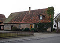
- Klebheimer Str. 3: Half-timbered barn from the 18th century
- Ringstrasse 8: house figure
- Ringstrasse 13: residential stable house
Population development
| year | 1818 | 1861 | 1871 | 1885 | 1900 | 1925 | 1950 | 1961 | 1970 | 1987 | 2013 |
|---|---|---|---|---|---|---|---|---|---|---|---|
| Residents | 105 | 154 | 147 | 159 | 155 | 187 | 221 | 220 | 239 | 344 | 497 |
| Houses | 21st | 30th | 28 | 31 | 35 | 39 | 99 | ||||
| source |
religion
The place was purely Catholic until the beginning of the 20th century and has been parish since 1574 after the birth of Mary (Hannberg) . The residents of the Evangelical Lutheran denomination are parish to St. Kilian (Kairlindach) .
traffic
The national road 2240 goes according Klebheim (1.2 km north) or after Hannberg (km southeast 1.2). A community road runs to Dannberg (1.4 km to the west).
The Franconian Marienweg runs through the village .
gallery

Crucifixion group

Sculpture crucifixion group
Stadel, 18th century

Stadel, 18th century

House figure in niche
.jpg)
.jpg)
.jpg)
.jpg)
.jpg)
literature
- Johann Kaspar Bundschuh : Niederlindach . In: Geographical Statistical-Topographical Lexicon of Franconia . tape 4 : Ni-R . Verlag der Stettinische Buchhandlung, Ulm 1801, DNB 790364301 , OCLC 833753101 , Sp. 5 ( digitized version ).
- Georg Daßler (Ed.): District of Höchstadt ad Aisch. Past and present . Verl. F. Authorities and Wirtschaft Hoeppner, Aßling-Munich 1970, DNB 457004320 , p. 74 .
- Hanns Hubert Hofmann : Höchstadt-Herzogenaurach (= Historical Atlas of Bavaria, part Franconia . I, 1). Commission for Bavarian State History, Munich 1951, DNB 452071143 ( digitized version ).
- Franz Krug (ed.): The district of Erlangen-Höchstadt . Publishing house for authorities a. Wirtschaft, Hof (Saale) 1979, ISBN 3-921603-00-5 , p. 128 .
Web links
- Niederlindach in the location database of the Bavarian State Library Online . Bavarian State Library, accessed on October 8, 2019.
- Niederlindach in the Topographia Franconiae of the University of Würzburg , accessed on October 8, 2019.
- Niederlindach in the historical directory of the Association for Computer Genealogy , accessed on October 8, 2019
Individual evidence
- ↑ a b Niederlindach in the Bavaria Atlas
- ^ Hans Schaub: Wehrkirche zu Hannberg , Bamberg, 2007.
- ↑ F. Krug (ed.), P. 128 = G. Daßler (ed.), P. 74.
- ^ Hanns Hubert Hofmann : Höchstadt-Herzogenaurach (= Historical Atlas of Bavaria, part of Franconia . I, 1). Commission for Bavarian State History, Munich 1951, DNB 452071143 , p. 76 f . ( Digitized version ).
- ^ Hanns Hubert Hofmann : Höchstadt-Herzogenaurach (= Historical Atlas of Bavaria, part of Franconia . I, 1). Commission for Bavarian State History, Munich 1951, DNB 452071143 , p. 142 ( digitized version ).
- ↑ Only inhabited houses are given. In 1818 these were designated as fireplaces , from 1871 to 1987 as residential buildings.
- ↑ Alphabetical index of all the localities contained in the Rezatkkreis according to its constitution by the newest organization: with indication of a. the tax districts, b. Judicial Districts, c. Rent offices in which they are located, then several other statistical notes . Ansbach 1818, p. 64 ( digitized version ).
- ^ Joseph Heyberger, Chr. Schmitt, v. Wachter: Topographical-statistical manual of the Kingdom of Bavaria with an alphabetical local dictionary . In: K. Bayer. Statistical Bureau (Ed.): Bavaria. Regional and folklore of the Kingdom of Bavaria . tape 5 . Literary and artistic establishment of the JG Cotta'schen Buchhandlung, Munich 1867, Sp. 876 , urn : nbn: de: bvb: 12-bsb10374496-4 ( digitized version ).
- ↑ Kgl. Statistical Bureau (ed.): Complete list of localities of the Kingdom of Bavaria. According to districts, administrative districts, court districts and municipalities, including parish, school and post office affiliation ... with an alphabetical general register containing the population according to the results of the census of December 1, 1875 . Adolf Ackermann, Munich 1877, 2nd section (population figures from 1871, cattle figures from 1873), Sp. 1049 , urn : nbn: de: bvb: 12-bsb00052489-4 ( digitized version ).
- ↑ K. Bayer. Statistical Bureau (Ed.): Localities directory of the Kingdom of Bavaria. According to government districts, administrative districts, ... then with an alphabetical register of locations, including the property and the responsible administrative district for each location. LIV. Issue of the contributions to the statistics of the Kingdom of Bavaria. Munich 1888, Section III, Sp. 994 ( digitized version ).
- ↑ K. Bayer. Statistical Bureau (Ed.): Directory of localities of the Kingdom of Bavaria, with alphabetical register of places . LXV. Issue of the contributions to the statistics of the Kingdom of Bavaria. Munich 1904, Section II, Sp. 1043 ( digitized version ).
- ↑ Bavarian State Statistical Office (ed.): Localities directory for the Free State of Bavaria according to the census of June 16, 1925 and the territorial status of January 1, 1928 . Issue 109 of the articles on Bavaria's statistics. Munich 1928, Section II, Sp. 1077 ( digitized version ).
- ↑ Bavarian State Statistical Office (ed.): Official place directory for Bavaria - edited on the basis of the census of September 13, 1950 . Issue 169 of the articles on Bavaria's statistics. Munich 1952, DNB 453660975 , Section II, Sp. 923 ( digitized version ).
- ↑ Bavarian State Statistical Office (ed.): Official city directory for Bavaria, territorial status on October 1, 1964 with statistical information from the 1961 census . Issue 260 of the articles on Bavaria's statistics. Munich 1964, DNB 453660959 , Section II, Sp. 679 ( digitized version ).
- ^ Bavarian State Statistical Office (ed.): Official place directory for Bavaria . Issue 335 of the articles on Bavaria's statistics. Munich 1973, DNB 740801384 , p. 173 ( digitized version ).
- ↑ Bavarian State Office for Statistics and Data Processing (Ed.): Official local directory for Bavaria, territorial status: May 25, 1987 . Issue 450 of the articles on Bavaria's statistics. Munich November 1991, DNB 94240937X , p. 334 ( digitized version ).

Dannberg | Hannberg | Hessdorf | Hesselberg | Klebheim | Central membrane | Niederlindach | Obermembach | Röhrach | Unterermembach