
Hannberg (Hessdorf)
|
Hannberg
Municipality of Heßdorf
Coordinates: 49 ° 38 ′ 15 ″ N , 10 ° 54 ′ 11 ″ E
|
|
|---|---|
| Height : | 303 m above sea level NHN |
| Residents : | 420 (July 1, 2013) |
| Incorporation : | July 1, 1972 |
| Postal code : | 91093 |
| Area code : | 09135 |
_mit_Wehrkirche_Geburt_Mariens,_Landkreis_Erlangen-H%C3%B6chstadt.jpg)

,_Landkreis_Erlangen-H%C3%B6chstadt,_Foto_1960.jpg)
Hannberg is a district of the municipality of Heßdorf in the Erlangen-Höchstadt district in Middle Franconia ( Bavaria ).
geography
The parish village is located in the Seebachgrund , an area characterized by hills and ponds, about ten kilometers from Erlangen and Herzogenaurach . The Käferhölleinin borders in the east . Otherwise the place is immediately surrounded by arable land and grassland. In the west the corridor is called Espach , in the north Klingen .
history
The first documentary mention of Hannberg under the name "Hagenenberc" (a mountain surrounded by thorns) on the occasion of a gift from Bishop Gunther von Bamberg to his cathedral chapter comes from the year 1065 . The place presumably existed earlier, as "six courtyards" in Hannberg are mentioned in a register of the Benedictine nuns' monastery in Kitzingen , dated around 1040 . In the First Margrave War in 1449/50 , Hannberg and the entire Seebachgrund were largely devastated. In 1461, during the early mass of the patrician Johann Igelthaler, the right of patronage was transferred to the city of Nuremberg. As a result, the weir system was built between 1461 and 1486.
From 1500 onwards, Hannberg was heavily frequented by pilgrims as a place of pilgrimage, described in 1653 in detailed reports by the Jesuit Father Gammas. The reason for this was a pietà with folded hands, venerated as the Hannberger image of grace. From 1543 the place was temporarily led by Protestant pastors and in 1575 elevated to a Catholic parish. In the Thirty Years War (1618–48) Hannberg was initially not involved. However, in 1632 the village and the fortified church were looted, and the pastor was kidnapped and only released for a ransom.
At the end of the 18th century there were 8 properties in Hannberg. The high court exercised the Bamberg center office Herzogenaurach . The Oblei Hannberg of the Bamberg cathedral chapter held the village and community rulership. The landlord of all properties was the Bamberg Cathedral Chapter (Oblei Hannberg: 1 courtyard, 1 half courtyard, 1 estate, 1 tavern; Hannberg fragment: 2 courtyards, 1 forge, 1 inn).
In 1810 Hannberg came to the new Kingdom of Bavaria . As part of the municipal edict , the Hannberg tax district was formed in 1811 , to which Dannberg , Großdechsendorf , Großenseebach , Heßdorf , Klebheim , Kleindechsendorf , Neuenbürg , Niederlindach , Röhrach and Untermembach belonged. With the second community edict (1818), the places were assigned to the following newly formed rural communities :
- Großdechsendorf with Kleindechsendorf,
- Großenseebach,
- Hannberg with Dannberg, Klebheim, Niederlindach and Röhrach,
- Heßdorf with Untermembach,
- Neuenbürg to the rural community of Reinersdorf .
The administration and jurisdiction of the municipality of Hannberg was subordinate to the Herzogenaurach Regional Court and the financial administration to the Erlangen Rent Office . On October 1, 1847, the financial management was taken over by the Rentamt Herzogenaurach . From 1862 Hannberg was administered by the district office of Höchstadt an der Aisch (renamed the district of Höchstadt an der Aisch in 1938 ) and continued to be administered by the rent office Herzogenaurach (1920–1929: Finanzamt Herzogenaurach , from 1929: Finanzamt Erlangen ). The jurisdiction remained with the district court of Herzogenaurach until 1879, 1880–1959 district court of Herzogenaurach , from 1959 district court of Erlangen . The municipality had an area of 9,450 km².
In the course of the regional reform in Bavaria , Hannberg and all its districts were incorporated into the municipality of Heßdorf on July 1, 1972.
Attractions
Hannberg fortified church
The Church of the Birth of Mary is a fortified church and has a 50 meter high church tower with four "black watch towers" and a 22 meter high hipped roof . The entire weir system from 1486 has largely been preserved in its original form and has a closed circular wall with dimensions of 73.50 × 56.20 meters. A special feature are the four integrated defense towers with loopholes to the outside and inside. The church has late Gothic stone altars and sculptures of the holy virgins Katharina and Margareta (1475) and Barbara (1485) as well as the central figure of Our Lady with the baby Jesus (1485). There are also several Baroque sculptures from around 1720.
From Gagern graves
In the inner courtyard of the fortified church are the graves of the von Gagern family , descendants of Heinrich von Gagern , who was elected President of the German National Assembly in the Paulskirche in Frankfurt on May 19, 1848 . A plaque commemorates Ernst Freiherr von Gagern, who was the successor to the commandant of the Emden in the sea battle on the Skagerrak.
Underground tunnels
Underground passages from the fortified church Hannberg were discovered during road works in 1960. The excavated tunnel to the fortified church is no longer visible due to new buildings. In the historical case of defense, the trapped population could escape through the tunnel outside of the village. The corridors are not yet generally accessible.
Landmarks
In Hannberg there are two historically relevant wayside shrines, a stone marter on Kirchenplatz from 1575 and a late Gothic wayside shrine on Röhrracher Straße from 1480. In addition, at the exit from Hannberg towards Heßdorf there is a stone cross, the Pflugreutmarterl, which was created at the beginning of the 16th century.
Hannberger cellar
At the beginning of the 20th century, cellars up to 100 meters deep were carved into the sandstone hills of Hannberg. They were usually used to cool beer. You can still find them on Röhrracher Straße.
Population development
Hannberg community
| year | 1818 | 1840 | 1852 | 1855 | 1861 | 1867 | 1871 | 1875 | 1880 | 1885 | 1890 | 1895 | 1900 | 1905 | 1910 | 1919 | 1925 | 1933 | 1939 | 1946 | 1950 | 1952 | 1961 | 1970 |
|---|---|---|---|---|---|---|---|---|---|---|---|---|---|---|---|---|---|---|---|---|---|---|---|---|
| Residents | 298 | 385 | 357 | 355 | 361 | 360 | 368 | 352 | 385 | 407 | 386 | 394 | 383 | 411 | 422 | 437 | 426 | 432 | 414 | 596 | 628 | 612 | 543 | 629 |
| Houses | 51 | 66 | 74 | 74 | 74 | 83 | 92 | |||||||||||||||||
| source |
Location Hannberg
| year | 1818 | 1861 | 1871 | 1885 | 1900 | 1925 | 1950 | 1961 | 1970 | 1987 | 2013 |
|---|---|---|---|---|---|---|---|---|---|---|---|
| Residents | 79 | 88 | 90 | 87 | 92 | 87 | 187 | 154 | 208 | 379 | 420 |
| Houses | 12 | 18th | 19th | 18th | 20th | 25th | 80 | ||||
| source |
Soil monuments
See: List of soil monuments in Heßdorf
religion
The place was purely Catholic until the beginning of the 20th century and has been parish since 1574 after the birth of Mary (Hannberg) . The residents of the Evangelical Lutheran denomination are parish to St. Kilian (Kairlindach) .
Culture
Cultural events and festivals in Hannberg with importance for the entire district of Erlangen-Höchstadt are:
- Balloon meeting
- is an annual event usually organized at the end of June by the regulars' table of the never-tired. It is celebrated with a bonfire in which over a thousand visitors take part.
- Carnival of the regulars' tables
- The multi-purpose hall Seebachgrund is the annual venue for the largest carnival event in the Erlangen-Höchstadt district. It is organized by the regulars' tables in Hannberg, Heßdorf and Niederlindach .
- Open Air in Hannberg
- is an annual event organized by the youth team of the Catholic Church in Hannberg
- Hannberger Kirchweih
- the second weekend in September
Infrastructure
school and education
primary school
_im_Landkreis_Erlangen-H%C3%B6chstadt..JPG)
In 1656 the first school in Hannberg was set up on the premises of the fortified church, which was used for school lessons until 1963. From 1879, another school building was built in the north-west of the village and used until 1963. In 1963 a new building for the elementary school was built and expanded in 1978. It is currently used as a primary school with four classes and around 90 children. A renovation is planned from 2014.
Kindergarten St. Marien
In 1977 the St. Marien kindergarten was built. The carrier is the Catholic Church Nativity of Mary in Hannberg. There are currently 92 children in four groups aged two to six years.
traffic
The national road 2240 goes according Heßdorf (1.2 km south-east) and after Niederlindach (km northwest 1.2). The district road ERH 26 runs to Großenseebach (1.5 km southwest) or via Röhrach to state road 2259 (1.8 km northeast).
The Franconian Marienweg runs through the village .

Village square
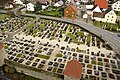
Church cemetery

First school 1656

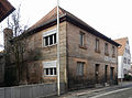
Old school house 1879
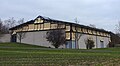
Multi-purpose hall Seebachgrund

from Gagern graves

Wayside shrine church square
Sandstone block construction
_im_Landkreis_Erlangen-H%C3%B6chstadt..JPG)
_im_Landkreis_Erlangen-H%C3%B6chstadt..JPG)

_im_Landkreis_Erlangen-H%C3%B6chstadt..JPG)
_im_Landkreis_Erlangen-H%C3%B6chstadt..jpg)
_Kirchenburg_Gagern_Familiengruft_002.JPG)
_Bildstock_Kirchenplatz_001.JPG)
.jpg)
literature
- Johann Kaspar Bundschuh : Hannberg . In: Geographical Statistical-Topographical Lexicon of Franconia . tape 2 : El-H . Verlag der Stettinische Buchhandlung, Ulm 1800, DNB 790364298 , OCLC 833753081 , Sp. 495 ( digitized version ).
- Johann Kaspar Bundschuh : Hennewerich . In: Geographical Statistical-Topographical Lexicon of Franconia . tape 2 : El-H . Verlag der Stettinische Buchhandlung, Ulm 1800, DNB 790364298 , OCLC 833753081 , Sp. 593 ( digitized version ).
- Georg Daßler (Ed.): District of Höchstadt ad Aisch. Past and present . Verl. F. Authorities and Wirtschaft Hoeppner, Aßling-Munich 1970, DNB 457004320 , p. 73 .
- Hanns Hubert Hofmann : Höchstadt-Herzogenaurach (= Historical Atlas of Bavaria, part Franconia . I, 1). Commission for Bavarian State History, Munich 1951, DNB 452071143 , p. 67 ( digitized version ). Ibid. S. 142 ( digitized version ).
- Franz Krug (ed.): The district of Erlangen-Höchstadt . Publishing house for authorities a. Wirtschaft, Hof (Saale) 1979, ISBN 3-921603-00-5 , p. 126-127 .
- Hans Schaub: Wehrkirche zu Hannberg , Bamberg 2007.
Web links
- Hannberg in the location database of the Bayerische Landesbibliothek Online . Bavarian State Library, accessed on October 8, 2019.
- Hannberg in the Topographia Franconiae of the University of Würzburg , accessed on October 8, 2019.
- Hannberg in the historical directory of the association for computer genealogy
- Homepage Stammtisch Nimmermüden Hannberg
Individual evidence
- ↑ a b Hannberg in the Bavaria Atlas
- ^ Robert Noppenberger, Thomas Willert "Hannberg", Heßdorf community 2019, ISBN 978-3-00-064396-5
- ↑ F. Krug (Ed.), P. 126f. = G. Daßler (Ed.), Pp. 73f. Supplemented by Hans Schaub: Wehrkirche zu Hannberg and website about the fortified church Hannberg .
- ^ HH Hofmann: Höchstadt-Herzogenaurach , p. 67.
- ^ Address and statistical manual for the Rezatkreis in the Kingdom of Baiern . Buchdruckerei Chancellery, Ansbach 1820, p. 49 ( digitized version ).
- ^ HH Hofmann: Höchstadt-Herzogenaurach , p. 142.
- ↑ a b c Bavarian State Statistical Office (ed.): Official city directory for Bavaria, territorial status on October 1, 1964 with statistical information from the 1961 census . Issue 260 of the articles on Bavaria's statistics. Munich 1964, DNB 453660959 , Section II, Sp. 679 ( digitized version ).
- ^ Wilhelm Volkert (ed.): Handbook of Bavarian offices, communities and courts 1799–1980 . CH Beck, Munich 1983, ISBN 3-406-09669-7 , p. 484 .
- ↑ Home Wehrkirche Hannberg, www.wehrkirche-hannberg.de
- ↑ Dr. Ed. Rühl, Kulturkunde des Regnitzgrundes, Frankenverlag Lorenz Spindler, Nuremberg, 3rd edition, 1982
- ↑ a b Only inhabited houses are given. In 1818 these were designated as fireplaces , from 1871 to 1987 as residential buildings.
- ↑ a b Alphabetical index of all the localities contained in the Rezatkreise according to its constitution by the newest organization: with indication of a. the tax districts, b. Judicial Districts, c. Rent offices in which they are located, then several other statistical notes . Ansbach 1818, p. 36 ( digitized version ). For the municipality of Hannberg plus the residents and fire places of Dannberg (p. 17), Klebheim (p. 48), Niederlindach (p. 64) and Röhrach (p. 76).
- ↑ a b c d e f g h i j k l m n o Bavarian State Statistical Office (Hrsg.): Historical municipality register: The population of the municipalities of Bavaria from 1840 to 1952 (= contributions to Statistics Bavaria . Issue 192). Munich 1954, DNB 451478568 , p. 145 , urn : nbn: de: bvb: 12-bsb00066439-3 ( digitized version ).
- ↑ a b Joseph Heyberger, Chr. Schmitt, v. Wachter: Topographical-statistical manual of the Kingdom of Bavaria with an alphabetical local dictionary . In: K. Bayer. Statistical Bureau (Ed.): Bavaria. Regional and folklore of the Kingdom of Bavaria . tape 5 . Literary and artistic establishment of the JG Cotta'schen Buchhandlung, Munich 1867, Sp. 876 , urn : nbn: de: bvb: 12-bsb10374496-4 ( digitized version ).
- ↑ a b Kgl. Statistical Bureau (ed.): Complete list of localities of the Kingdom of Bavaria. According to districts, administrative districts, court districts and municipalities, including parish, school and post office affiliation ... with an alphabetical general register containing the population according to the results of the census of December 1, 1875 . Adolf Ackermann, Munich 1877, 2nd section (population figures from 1871, cattle figures from 1873), Sp. 1049-1052 , urn : nbn: de: bvb: 12-bsb00052489-4 ( digitized version ).
- ↑ a b K. Bayer. Statistical Bureau (Ed.): Localities directory of the Kingdom of Bavaria. According to government districts, administrative districts, ... then with an alphabetical register of locations, including the property and the responsible administrative district for each location. LIV. Issue of the contributions to the statistics of the Kingdom of Bavaria. Munich 1888, Section III, Sp. 994 ( digitized version ).
- ↑ a b K. Bayer. Statistical Bureau (Ed.): Directory of localities of the Kingdom of Bavaria, with alphabetical register of places . LXV. Issue of the contributions to the statistics of the Kingdom of Bavaria. Munich 1904, Section II, Sp. 1043 ( digitized version ).
- ↑ a b Bavarian State Statistical Office (ed.): Localities directory for the Free State of Bavaria according to the census of June 16, 1925 and the territorial status of January 1, 1928 . Issue 109 of the articles on Bavaria's statistics. Munich 1928, Section II, Sp. 1076-1077 ( digitized version ).
- ↑ a b Bavarian State Statistical Office (ed.): Official place directory for Bavaria - edited on the basis of the census of September 13, 1950 . Issue 169 of the articles on Bavaria's statistics. Munich 1952, DNB 453660975 , Section II, Sp. 923 ( digitized version ).
- ↑ a b Bavarian State Statistical Office (Hrsg.): Official local directory for Bavaria . Issue 335 of the articles on Bavaria's statistics. Munich 1973, DNB 740801384 , p. 173 ( digitized version ).
- ↑ Bavarian State Office for Statistics and Data Processing (Ed.): Official local directory for Bavaria, territorial status: May 25, 1987 . Issue 450 of the articles on Bavaria's statistics. Munich November 1991, DNB 94240937X , p. 334 ( digitized version ).

Dannberg | Hannberg | Hessdorf | Hesselberg | Klebheim | Central membrane | Niederlindach | Obermembach | Röhrach | Unterermembach