Northwest Piscataquis
| Northwest Piscataquis | ||
|---|---|---|
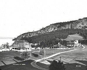
 Kineo Cottages around 1900 |
||
| Location in Maine | ||
|
|
||
| Basic data | ||
| State : | United States | |
| State : | Maine | |
| County : | Piscataquis County | |
| Coordinates : | 46 ° 4 ′ N , 69 ° 29 ′ W | |
| Time zone : | Eastern ( UTC − 5 / −4 ) | |
| Residents : | 147 (as of 2010) | |
| Population density : | 0 inhabitants per km 2 | |
| Area : | 4,226.8 km 2 (approx. 1,632 mi 2 ) of which 3,554.5 km 2 (approx. 1,372 mi 2 ) is land |
|
| Height : | 334 m | |
| Postcodes : | 04441, 04462, 04442 | |
| Area code : | +1 207 | |
| FIPS : | 53628 | |
| GNIS ID : | 582640 | |
Northwest Piscataquis is an Unorganized Territory in Piscataquis County in the state of Maine in the United States . The area is administered by the state. In 2010, 147 people lived there in 1040 households (in the United States vacation rentals are also counted as households) on an area of 4226.8 km². The name Piscataquis comes from the Abenaki language and means "on the arm of the river".
geography
According to the United States Census Bureau , Northwest Piscataquis has a total area of 4,226.8 km², of which 3554.5 km² are land and 672.3 km² are water .
Geographical location
Northwest Piscataquis is in the northwest of Piscataquis County and is bordered by Aroostook County to the north and Somerset County to the west . Many small and large lakes run through the area, such as Eagel Lake , Chamberlain Lake , Chesuncook Lake and Moosehead Lake as well as other smaller and larger lakes. In total, almost 16% of the surface consists of water. The surface is slightly hilly, with the 977 m high Big Spencer Mountain in the center of the area.
Neighboring communities
All distances are given as straight lines between the official coordinates of the places from the 2010 census.
- North: Northwest Aroostook , Aroostook County, Unorganized Territory, 56 mi
- East: Northeast Piscataquis , Unorganized Territory, 21 mi
- Southeast: Beaver Cove , km; Greenville , 41.4 mi
- South: Shirley , 49.5 miles
- Southwest: Northeast Somerset , Somerset County, Unorganized Territory, 45 mi
- West: Seboomook Lake , Somerset County, Unorganized Territory, 23 mi
City structure
There are several settlement areas in Northwest Piscataquis: Moosehead , North East Carry , Kokadjo and Chesuncook .
history
The Northwest Piscataquis area is an extremely sparsely populated area. The north is almost entirely uninhabited. In the area there are some smaller settlements, some of which have been placed under monument protection. There are also many archaeological sites in the area that have also been placed under protection.
Population development
| Census Results - Northwest Piscataquis, Maine | ||||||||||
|---|---|---|---|---|---|---|---|---|---|---|
| year | 1900 | 1910 | 1920 | 1930 | 1940 | 1950 | 1960 | 1970 | 1980 | 1990 |
| Residents | 99 | 141 | ||||||||
| year | 2000 | 2010 | 2020 | 2030 | 2040 | 2050 | 2060 | 2070 | 2080 | 2090 |
| Residents | 159 | 147 | ||||||||
Culture and sights
Buildings
In Northwest Piscataquis, several archaeological sites at Ambajejus Camps, Chesuncook, Millinocket Lake, Ripogenus Gorge, and Stephensons Landing, as well as two structures, a historic settlement and a quarry, have been listed and listed on the National Register of Historic Places . The location of the archaeological sites is not disclosed.
- Chesuncook Village , 1973 under the register no. 73000262.
- Willard Brook Quarry , 1986 under the register no. 86002182.
- Boarding House and Storehouse at Churchill Depot , 2018 under registration no. 100003258.
- Kineo Cottage Row Historic District , registered in 2004 under no. 03001408.
- The Breakwater in Rockwood, 2003 under registration no. 02000349.
Parks
Mount Kineo State Park is located on an island in Moosehead Lake.
Economy and Infrastructure
traffic
Maine State Route 6 runs through southwest of Northwest Piscataquis . The rest of the area is very little developed.
Public facilities
There are no medical facilities or hospitals in Northwest Piscataquis. Closest facilities for Northwest Piscataquis residents are in Millinocket and Greenville.
Northwest Piscataquis does not have its own library; the closest one is in Greenville.
education
As an Unorganized Territory, the area of Northwest Piscataquis is administered by the state of Maine, which is also responsible for the educational offers.
Web links
Individual evidence
- ^ Northwest Piscataquis in the Geographic Names Information System of the United States Geological Survey , accessed January 18, 2020
- ↑ Maine 2010 Census Results ; official publication of the Census Authority, (English; PDF; 32.5 MB)
- ^ Sandy Nestor: Indian Placenames in America . McFarland, 2015, ISBN 978-0-7864-9339-5 ( books.google.de ).
- ↑ Big Spencer Mountain. In: peakery.com. Retrieved January 18, 2020 .
- ↑ Coordinates of the locations of the Census Authority 2010
- ↑ Population 1980–2010 according to census results
- ↑ Chesuncook Village 73000262
- ↑ Willard Brook Quarry in Chesuncook 86002182
- ^ Boarding House and Storehouse at Churchill Depot 100003258
- ↑ Kineo Cottage Row Historic District 03001408
- ↑ The Breakwater 02000349
- ^ State Parks and Public Lands: Maine ACF. In: maine.gov. Retrieved January 18, 2020 .
