
Northeast Piscataquis
| Northeast Piscataquis | |||
|---|---|---|---|
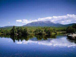 Mount Katahdin |
|||
| Location in Maine | |||
|
|||
| Basic data | |||
| State : | United States | ||
| State : | Maine | ||
| County : | Piscataquis County | ||
| Coordinates : | 45 ° 55 ′ N , 69 ° 6 ′ W | ||
| Time zone : | Eastern ( UTC − 5 / −4 ) | ||
| Residents : | 273 (as of 2010) | ||
| Population density : | 0.1 inhabitants per km 2 | ||
| Area : | 4,714.8 km 2 (approx. 1,820 mi 2 ) of which 4,430.3 km 2 (approx. 1,711 mi 2 ) is land |
||
| Height : | 428 m | ||
| Postcodes : | 04732, 04462, 04441, 04414, 04464, 04443 | ||
| Area code : | +1 207 | ||
| FIPS : | 23-51105 | ||
| GNIS ID : | 582629 | ||
 Ambajejus Boom House |
|||

Northeast Piscataquis is an Unorganized Territory in Piscataquis County in the state of Maine in the United States . The area is administered by the state. In 2010, 273 people lived there in 1351 households (in the United States vacation rentals are also counted as households) on an area of 4714.8 km². In the area of Northeast Piscataquis lies the highest mountain in the state of Maine, Mount Katahdin . The name Piscataquis comes from the Abenaki language and means "on the arm of the river".
geography
According to the United States Census Bureau , Northeast Piscataquis has a total area of 4,714.8 km², of which 4,430.3 km² are land and 284.5 km² consist of water .
Geographical location
Northeast Piscataquis is located in northeast Piscataquis County and is bordered to the north by Aroostook County and to the east by Penobscot County . Mount Katahdin, 1606 m high, is centrally located in the area. Many small and large lakes criss-cross the area, such as Pemadumcook Lake in the southeast or Telos Lake in the west. The area around Mount Katahdin was protected as a Baxter State Park .
Neighboring communities
All distances are given as straight lines between the official coordinates of the places from the 2010 census.
- North: Northwest Aroostook , Aroostook County, Unorganized Territory, 64.9 mi
- Northeast: North Penobscot , Penobscot County, Unorganized Territory, 20 mi
- Southeast: Brownville , 38 mi
- South: Sebec , 75.1 km; Bowerbank , 76.5 km; Willimantic , 71.7 km; Monson , 47 miles
- Southwest: Shirley , 74.2 km
- West: Greenville , 38.1 miles; Beaver Cove , 50.1 km; Northwest Piscataquis 21.3 miles
City structure
There are several settlement areas in Northeast Piscataquis: Williamsburg Township , Ebeemee Township , Bodfish , Onawa , Schoodic , Kokadjo , Pine Knoll , New City, and Old City .
history
The Northeast Piscataquis area is an extremely sparsely populated area. The north is almost entirely unpopulated and includes nature reserves and state parks. However, some areas in the southern part were independent plantations or towns , whose organizational status was later given up. This is mostly done for economic and organizational reasons. The few residents are mostly unable to cope with the communal tasks that these forms of organization entail.
The area was used for logging. The Ambajejus Boom House , built in 1907 on a small island in Ambajejus Lake at a narrow point , was the only remaining structure associated with the logging in the forests of central Maine. It was listed and renovated in 1973. The house is about 30 m long, 4.6 m wide and divided into three sections. A corresponding structure had existed at this point since 1835, as tree trunks could be collected here through the narrow part of the river and then towed through the chain of lakes to the North Twin Dam to the paper mills in Millinocket. There they were sent further downstream. This took place on the West Branch of the Penobscot River until 1971.
In 1820, Williamsburg, to the south between Bowerbank and Brownville, was organized as a town. Previously the area was organized as the Williamsburg Plantation. It was measured as Easterly part of Township No. 6, Eighth Range North of Waldo Patent (T6 R8 NWP) , thus belonged to the Waldo patent . The organization was abandoned in 1939 and Williamsburg was incorporated into the Northeast Piscataquis area.
Today, the area attracts tourists thanks to Baxter State Park, Mount Katahdin and the numerous lakes and forests. The Appalachian Trail runs through Northeast Piscataquis and ends at Mount Katahdin.
Population development
| Census Results - Northeast Piscataquis, Maine | ||||||||||
|---|---|---|---|---|---|---|---|---|---|---|
| year | 1900 | 1910 | 1920 | 1930 | 1940 | 1950 | 1960 | 1970 | 1980 | 1990 |
| Residents | 132 | 218 | ||||||||
| year | 2000 | 2010 | 2020 | 2030 | 2040 | 2050 | 2060 | 2070 | 2080 | 2090 |
| Residents | 347 | 273 | ||||||||
Culture and sights
Buildings
In Northeast Piscataquis, an archaeological district, archaeological site and structure have been listed and listed on the National Register of Historic Places . The exact location of archaeological sites is not disclosed to protect them.
- Munsungan-Chase Lake Thoroughfare Archeological District at Millinocket Lake , 1979 under registration no. 79000163.
- Archeological Site No. 122-4a , 1995 under the register no. 95001202.
- Ambajejus Boom House , 1973 under the register no. 73000145.
Parks
The Baxter State Park , a large wildlife area, as a state park is protected, is in the area of Northeast Piscataquis. In it is the highest mountain of Maine, Mount Katahdin . Baxter State Park was established in 1931. The Katahdin Woods and Waters National Monument borders the state park to the east.
Centrally located is the Nahmakanta Public Reserved Land and the Debsconeag Lakes Wilderness Area .
Economy and Infrastructure
traffic
Maine State Route 11 runs through the southeast of Northeast Piscataquis . The rest of the area is very little developed.
Public facilities
There are no medical facilities or hospitals in Northeast Piscataquis. Closest facilities for Northeast Piscataquis residents are in Millinocket and Greenville.
Northeast Piscataquis does not have its own library; the closest ones are in Brownville and Millinocket.
education
As an Unorganized Territory, the area of Northeast Piscataquis is administered by the state of Maine, which is also responsible for the educational offers.
Web links
Individual evidence
- ^ Northeast Piscataquis in the Geographic Names Information System of the United States Geological Survey , accessed January 18, 2020
- ↑ Maine 2010 Census Results ; official publication of the Census Authority, (English; PDF; 32.5 MB)
- ^ Sandy Nestor: Indian Placenames in America . McFarland, 2015, ISBN 978-0-7864-9339-5 ( books.google.de ).
- ↑ Mount Katahdin, Baxter Peak. In: peakery.com. Retrieved January 18, 2020 .
- ↑ Coordinates of the locations of the Census Authority 2010
- ↑ NPGallery Asset Detail. In: nps.gov. npgallery.nps.gov, accessed January 19, 2020 .
- ^ Williamsburg Township, Piscataquis County - Maine Genealogy. In: mainegenealogy.net. Retrieved January 18, 2020 .
- ↑ Population 1980–2010 according to census results
- ^ Munsungan-Chase Lake Thoroughfare Archeological District 79000163
- ↑ Archeological Site No. 122-4a 95001202
- ↑ Ambajejus Boom House 73000145
- ↑ Nahmakanta Public Reserved Land. In: nrcm.org. 2016, Retrieved January 18, 2020 (American English).
- ↑ Welcome to the Debsconeag Lakes Wilderness Area. In: nature.org. The Nature Conservancy, accessed January 18, 2020 (American English).
| Towns |
Abbot | Beaver Cove | Bow bench | Brownville | Dover-Foxcroft | Greenville | Guilford | Medford | Milo | Monson | Parkman | Sangerville | Sebec | Shirley | Wellington | Willimantic |
|
| Plantation | ||
| UTs |
Atkinson | Blanchard | Southeast Piscataquis | Northeast Piscataquis | Northwest Piscataquis |