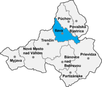
Okres Ilava
| Overview maps | |
|---|---|

|

|
| Basic data Okres Ilava | |
| Kraj : | Trenčiansky kraj |
| Area : | 358.5 km² |
| Residents : | 59,075 (December 31, 2019) |
| Population density : | 164.55 inhabitants / km² |
| License plate : | IL |
| District code: | 302 |
| Administrative division | |
| Cities: | 3 |
| Municipalities (excluding cities): | 18th |
| Statistics information about the Okres on statistics.sk | |
The Okres Ilava is an administrative region in the north-west of Slovakia km² with 61,422 inhabitants (2004) and an area of 359th
The district is located in the Waag Valley in the northern parts of the Trenčiansky kraj and is enclosed in the north by the White Carpathians and in the south by the Strážovské vrchy . In the north it borders on the Púchov district , in the east briefly on the districts Považská Bystrica and Žilina (in Žilinský kraj ), in the southeast on the Prievidza district , in the south and west on the Trenčín district and in the north on the Czech Republic .
Historically it is located in the former Trenčín county (see also the list of historical counties of Hungary ).
Cities
- Dubnica nad Váhom ( Dubnitz an der Waag )
- Ilava ( Illau )
- Nová Dubnica
Communities
|
|
The district office is in Trenčín , with branches in Ilava and Dubnica nad Váhom .
Culture
In the article Protected Objects in the Okres Ilava you can find about the objects in the Okres that are protected by the Slovak Monuments Office.