Košeca
| Košeca | ||
|---|---|---|
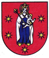
| coat of arms | map | |

|
|
|
| Basic data | ||
| State : | Slovakia | |
| Kraj : | Trenčiansky kraj | |
| Okres : | Ilava | |
| Region : | Stredné Považie | |
| Area : | 18.944 km² | |
| Residents : | 2,737 (Dec. 31, 2019) | |
| Population density : | 144 inhabitants per km² | |
| Height : | 255 m nm | |
| Postal code : | 018 64 | |
| Telephone code : | 0 42 | |
| Geographic location : | 49 ° 1 ' N , 18 ° 16' E | |
| License plate : | IL | |
| Kód obce : | 513253 | |
| structure | ||
| Community type : | local community | |
| Structure of the municipality: | 2 parts of the community | |
| Administration (as of November 2018) | ||
| Mayor : | Radomír Brtáň | |
| Address: | Obecný úrad Košeca 36 018 64 Košeca |
|
| Website: | www.koseca.sk | |
| Statistics information on statistics.sk | ||
Košeca (Hungarian Kasza - up to the 19th century also Kossa ) is a municipality in the Okres Ilava of the Trenčiansky kraj in northwestern Slovakia . On December 31, 2019, there were 2,737 inhabitants in the municipality.
geography
The municipality is located in the Považské podolie (Waag Valley area) on the left bank of the Waag , which is still behind a canal here. The Podhradský creek flows through the village . The Strážovské vrchy Mountains rise south-east of the village . Košeca is two kilometers from Ilava .
The municipality Nozdrovice (incorporated in 1895) also belongs to the municipality .
history
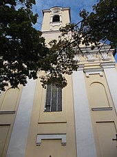
The place was first mentioned in writing in 1272 as Kassa and belonged to the manor of the Košeca Castle . Košeca was a market town in the Middle Ages. The main occupation of the local population was agriculture, handicrafts, cloth manufacture and timber trade. After the castle was razed by the imperial troops in 1671, the place became the new seat of the estate. The current Roman Catholic Church was completed in 1833.

