
Pößnitz (Black Elster)
| Poessnitz | ||
 |
||
| Data | ||
| Water code | DE : 538174 | |
| location | Brandenburg ( Germany ) | |
| River system | Elbe | |
| Drain over | Black Elster → Elbe → North Sea | |
| source | At the Sallgaster part of the municipality Henriette 51 ° 34 ′ 7 ″ N , 13 ° 52 ′ 8 ″ E |
|
| Source height | 156 m above sea level NHN | |
| muzzle | At Schwarzheide in the Black Elster Coordinates: 51 ° 27 '47 " N , 13 ° 53' 10" E 51 ° 27 '47 " N , 13 ° 53' 10" E |
|
| Mouth height | 97 m above sea level NHN | |
| Height difference | 59 m | |
| Bottom slope | 3.9 ‰ | |
| length | 15.1 km | |
| Left tributaries | Meuroer Graben , Wolschinka | |

The Pößnitz (formerly Pössnitz , Lower Sorbian Pěsnica ) is a right tributary of the Black Elster in Brandenburg .
course
The Pößnitz has its source southeast of Henriette , a former mining settlement. It passes Annahütte , then forms the border line between the villages of Klettwitz and Meuro and flows through the district of Schipkau - Krügers Mühle . The further course leads through BASF -Werk Schwarzheide and Schwarzheide district Naundorf where they ultimately into the Black Elster flows.
Side streams
On its course, the Pößnitz also absorbs the water of some small streams and ditches . The Meuroer Graben flows northwest of the Lausitzring near the Meuroer Friedhofsstraße. The mouth of the Moreitzmühlgraben is located at the Staudemühle in Klettwitz- Treuhandsiedlung and the former Moreitzbach flows not far from the Krügers Mühle directly to the federal motorway 13 .
history
Historically, the Pößnitz was a wetland with many tributaries, swamps , ponds and beaver dams . In addition to the beaver , it once provided habitat for numerous other animal species. With the emergence of lignite mining in Lusatia at the end of the 19th and beginning of the 20th century, the Pößnitz catchment area was largely drained and canalized . Today's Pößnitz was recorded as Pößnitzwasser in 1757 , whereas there was still a Pößnitzbach west of Schipkau , whose headwaters are recorded in the swamp and pond land between Pommelheide and Vogelberg . In the vicinity of the village of Naundorf an der Pößnitzmühle , there was a connecting channel to the Pößnitzwasser and the large Scyroteich .
Sights / monuments
- Barran mill in Meuro
- Staudemühle near Klettwitz
- Kruger mill near Schipkau
- Post bridge, at the Krügersmühle, approx. 120 years old
- Naundorfer Pößnitzmühle
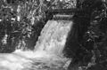
Naundorfer Pößnitzmühle (1988)

Naundorfer Pößnitzmühle (1988)


Web links
Individual evidence
- ↑ River directory gewnet25 (Version 4.0, April 24, 2014) from the Ministry for Rural Development, Environment and Agriculture of the State of Brandenburg, accessed on May 4, 2015.
- ↑ Pesnica - Lower Sorbian place names 1911-1928. Arnošt Muka - Sorbian Institute, Cottbus.
- ↑ 0010008, map of the Senftenberg office, 1757 (sign., VII 105)
- ↑ 0010010, map of the Senftenberg office, 1757 (sign., VII 105)
- ↑ List of monuments of the state of Brandenburg; Oberspreewald-Lausitz district; As of December 31, 2008; Postbrücke, at the Krügersmühle; Archived copy ( memento of the original from October 29, 2014 in the Internet Archive ) Info: The archive link was inserted automatically and has not yet been checked. Please check the original and archive link according to the instructions and then remove this notice. (PDF; 132 kB, p. 7).
.jpg)
.jpg)