Schipkau
| coat of arms | Germany map | |
|---|---|---|

|
Coordinates: 51 ° 31 ' N , 13 ° 53' E |
|
| Basic data | ||
| State : | Brandenburg | |
| County : | Oberspreewald-Lausitz | |
| Height : | 109 m above sea level NHN | |
| Area : | 68.95 km 2 | |
| Residents: | 6661 (Dec. 31, 2019) | |
| Population density : | 97 inhabitants per km 2 | |
| Postcodes : | 01968 (Hörlitz) 01993 (Schipkau) 01994 (Annahütte, Drochow, Meuro) 01998 (Klettwitz, Klettwitz-Barranmühle) |
|
| Area code : | 035754 | |
| License plate : | OSL, CA, SFB | |
| Community key : | 12 0 66 285 | |
| Community structure: | 6 districts | |
| Address of the municipal administration: |
Schulstr. 4 01998 Schipkau OT Klettwitz |
|
| Website : | ||
| Mayor : | Klaus Prietzel ( CDU ) | |
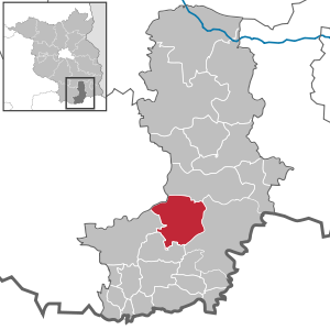
| Location of the community of Schipkau in the Oberspreewald-Lausitz district | ||
Schipkau ( Upper Sorbian Šejkow ) is a municipality in the Oberspreewald-Lausitz district in Brandenburg .
geography
The municipality of Schipkau is located in the southern part of the state of Brandenburg . Dresden's city limits are around 50 kilometers away, and it is around 100 kilometers to the Schönefelder Kreuz on the southern border of Berlin. The community is located in the middle of the Lower Lusatian lignite region.
Community structure
On December 31, 2001, six previously independent municipalities merged to form the municipality of Schipkau. Since then, Schipkau has consisted of the following districts:
- Annahütte ( Ždźarki )
- Drochow ( Drochow )
- Hörlitz ( Wórlica )
- Klettwitz ( Klěśišća )
- Meuro ( Murjow )
- Schipkau ( Šejkow )
The following residential areas and parcels belong to the districts of Schipkaus :
- Annahütte: Herrnmühle and Karl-Marx-Siedlung
- Klettwitz: Wilhelminensglück / Am Krankenhaus , Treuhandsiedlung , Staudemühle and the Barranmühle settlement , part of which also belongs to the Meuro district
- Schipkau: Living space Kruger mill that Gallows Hill settlement , the new neighborhood Rosa-Luxembourg-settlement and the remains of the colony Vogelsberg and the old village center from the Germanic modern times .
Administrative affiliation
- 1815–1945 District of Calau ( Province of Brandenburg , Prussia )
- 1945–1952 District of Calau ( State of Brandenburg )
- 1952–1990 Senftenberg district ( Cottbus district )
- 1990–1993 Senftenberg district (Brandenburg)
- since 1993 district Oberspreewald-Lausitz (Brandenburg)
Population development
|
|
|
|
|
Territory of the respective year, number of inhabitants: as of December 31 (from 1991), from 2011 based on the 2011 census
language
In the local documents Schipkaus is traditionally the niederlausitzische dialect and the Sorbian Koschener dialect (Košynska NaREC) spoken, and also in 1885 in the local documents Annahütte and Drochow almost repressed Schliebener dialect (Złowinska NaREC) of Lower Sorbian due to the influx of the new lignite coalfields to Cottbus , by Jänschwalder - Lehder (Janšojce-Lědjanska narěc) and Schleifer dialect (Slěpjanska narěc) was partially replaced today.
politics
Community representation
The community council of Schipkau consists of 18 community representatives and the full-time mayor. The local elections on May 26, 2019 led to the following result with a turnout of 59.5%:
| Party / group of voters | be right | Seats |
| CDU | 32.4% | 6th |
| AfD | 19.1% | 3 |
| The left | 15.4% | 3 |
| SPD | 15.3% | 3 |
| Meuro citizens' alliance | 9.1% | 2 |
| Independent citizens' association | 5.8% | 1 |
mayor
- 1998–2002: Jürgen Trabandt (SPD)
- 2002–2010: Siegurd Heinze
- since 2010: Klaus Prietzel (CDU)
Prietzel was elected in the mayoral election on May 30, 2010 with 61.7% of the valid votes. In the election on April 22, 2018, he was confirmed in office for a further eight years with 58.5% of the valid votes.
coat of arms
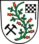
Blazon : "In silver, a cut, S-shaped green rose hip branch with six red fruits, bordered at the bottom right by a black mallet and iron crossed at an angle, at the top left by a flag waving to the right in black and silver."
The new coat of arms is divided in the middle by an "S" - shaped branch of a rose hip plant. The "S" stands for the first letter of the community Schipkau. The rose hip plant as a regionally native plant, which has increasingly spread again in the recultivated areas, also symbolizes the growing together of the six districts. The districts are shown as six rose hip fruits. In the lower left half of the coat of arms the mining symbol is arranged in the form of a mallet (hammer) and iron (chisel) . This symbolizes the tradition of mining in the municipality as the past. In the top right half of the illustration you can see a black and white nested start and finish flag. This stands for the development of the community of Schipkau with the aim of developing tourism and the resulting strengthening of the local economy and including the EuroSpeedway Lausitz, which is located in the center of the community of Schipkau.
The coat of arms was designed by the heraldist Frank Diemar .
flag
The flag of the municipality of Schipkau has two stripes of red and white with the municipality's coat of arms in the middle.
Attractions
- Lausitzring ( EuroSpeedway Lausitz )
- Henrietten Church Annahütte
- Herz-Jesu-Kirche Klettwitz
- Evangelical Church in Klettwitz
- Hörlitz observation tower
- Klettwitz mine
In the list of architectural monuments in Schipkau are the monuments entered in the list of monuments of the state of Brandenburg.
see also : List of natural monuments in Schipkau
Economy and Infrastructure
After the expiry of lignite mining ( open pit Klettwitz , open pit Klettwitz-Nord , open pit Meuro ), the community Schipkau has developed into a motor sports community. The EuroSpeedway Lausitz and the DEKRA Technology Center contribute to technological change and the modernization of the community's infrastructure.
Another landmark of the municipality is the Klettwitz wind park (consisting of several wind parks such as the Klettwitz-Nord wind park ), in which over 50 wind turbines have been generating electrical energy for tens of thousands of households for several years. The Schipkau solar park with an output of 72 MWp is part of the Senftenberg solar complex opened in 2011 .
traffic
Schipkau is on the L 60 state road between Lauchhammer and Senftenberg . The Senftenberg bypass gave the Hörlitz district a direct connection to the federal highway 169 . The A 13 Berlin – Dresden motorway crosses the municipality, the Klettwitz junction is on the municipality's territory.
Passenger traffic was discontinued in 1966 on the Finsterwalde – Schipkau and Schipkau – Senftenberg railway lines with the Schipkau , Klettwitz , Klettwitz Hospital and Annahütte stations .
The Schwarzheide-Schipkau airfield is in the Schipkau district .
Sports
The German Touring Car Masters (DTM) races take place every year at the Lausitzring . The community's football club is SV Askania Schipkau .
Personalities
Sons and daughters of the church
Annahütte
- Walter Nowojski (1931–2012), Germanist
- Daniela Döring (* 1966), professor for systems and control engineering
- Gerd Audehm (* 1968), cyclist
- Solveig August (born 1969), actress
Klettwitz
- Gottlob Schumann (1860–1929), mining director
- Robert Harnau (1908–1977), resistance fighter against National Socialism
- Gerd König (1930–2009), GDR diplomat
- Herbert Richter (1933–2018), chemist
- Fritz Stavenhagen (* 1945), actor
Meuro
- Rudolf Zernick (1929–1997), chemical engineer
Personalities associated with the community
- Golo Mann (1909–1994), writer, worked temporarily in 1928 in the Schipkau lignite mine
- Siegurd Heinze (* 1961), district administrator and mayor, grew up in Meuro
Web links
Individual evidence
- ↑ Population in the State of Brandenburg according to municipalities, offices and municipalities not subject to official registration on December 31, 2019 (XLSX file; 223 KB) (updated official population figures) ( help on this ).
- ↑ StBA: Changes in the municipalities in Germany, see 2001
- ^ Service portal of the state administration Brandenburg. Schipkau community
- ↑ List of monuments of the state of Brandenburg; Oberspreewald-Lausitz district; Status: December 31, 2008; Village center German Middle Ages, village center modern times. (→ p. 2) ( Memento of the original dated October 29, 2014 in the Internet Archive ) Info: The archive link was inserted automatically and has not yet been checked. Please check the original and archive link according to the instructions and then remove this notice. (PDF; 132 kB).
- ^ Historical municipality register of the state of Brandenburg 1875 to 2005. District Oberspreewald-Lausitz . Pp. 26-29
- ↑ Population in the state of Brandenburg from 1991 to 2015 according to independent cities, districts and municipalities , Table 7
- ^ Office for Statistics Berlin-Brandenburg (Ed.): Statistical report AI 7, A II 3, A III 3. Population development and population status in the state of Brandenburg (respective editions of the month of December)
- ^ Result of the local election on May 26, 2019
- ↑ Results of the local elections in 1998 (mayoral elections) for the Oberspreewald-Lausitz district ( Memento of the original from April 19, 2018 in the Internet Archive ) Info: The archive link was inserted automatically and has not yet been checked. Please check the original and archive link according to the instructions and then remove this notice.
- ↑ Local elections October 26, 2003. Mayoral elections , p. 28
- ↑ Brandenburg Local Election Act, Section 74
- ^ Result of the mayoral election on April 22, 2018
- ↑ Coat of arms information from the main statute of the municipality (PDF; 99 kB)
- ↑ Golo Mann: Memories and Thoughts , pp. 265–278


