
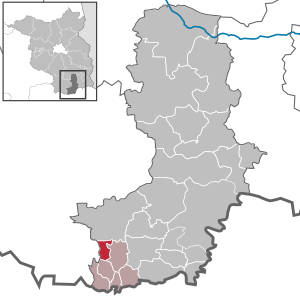
Tettau (Brandenburg)
| coat of arms | Germany map | |
|---|---|---|
.svg)
|
Coordinates: 51 ° 26 ' N , 13 ° 44' E |
|
| Basic data | ||
| State : | Brandenburg | |
| County : | Oberspreewald-Lausitz | |
| Office : | Outskirts | |
| Height : | 94 m above sea level NHN | |
| Area : | 8.84 km 2 | |
| Residents: | 763 (Dec. 31, 2019) | |
| Population density : | 86 inhabitants per km 2 | |
| Postal code : | 01945 | |
| Area code : | 03574 | |
| License plate : | OSL, CA, SFB | |
| Community key : | 12 0 66 316 | |
| Office administration address: | Altmarkt 10 01990 Ortrand |
|
| Website : | ||
| Mayor : | Joachim Nitzsche ( CDU ) | |
| Location of the municipality of Tettau / Oberlausitz in the Oberspreewald-Lausitz district | ||
  |
||

Tettau is a municipality in the Oberspreewald-Lausitz district in southern Brandenburg and part of the Ortrand office .
geography
Tettau is located in the extreme northwest of Upper Lusatia on the eastern border of the Schraden and on the western border of the district. The Schwarze Elster flows to the north and the Pulsnitz to the south .
The town of Lauchhammer borders on Tettau in the north, the town of Ruhland and the town of Frauendorf with the heather houses in the east . In the south are Lindenau and Ortrand . The Elbe-Elster district with the municipality of Schraden begins west of Tettau .
Community structure
Tettau has no officially defined districts, inhabited parts of the community or places to live .
history
Tettau was first mentioned in 1220 when the witness Lupoldus de Tettowe is mentioned in a document . The place name of the place laid out as a street village can be interpreted as Auort , the village was in the tip of the Upper Lusatia and was a corner post across from Mückenberg (today part of Lauchhammer). The place name developed from Tetthaw 1451 to Tetaw 1455 and Tettaw 1499 to Tetten in 1590 and Tettau in 1604.
From 1370 Tettau belongs to the countries of the crown of Bohemia . From 1530 the place was part of the parish of Lindenau. In 1611 it was part of the Ruhland manor and from 1679 the village belonged to the Lindenau manor. In 1802 the manor in Tettau burned down. In the early modern period, the Tettau people began to reclaim the damp lowlands of the neighboring Schraden by digging ditches. However, it was not until the 19th century that the area was drained with the dikes of the Black Elster and the straightening of the Pulsnitz.
In 1911 the cemetery and the sports field were laid out. 1953, the Tettau waterworks was built.
Administrative history
After the Congress of Vienna , Tettau came from the Kingdom of Saxony to the Kingdom of Prussia in 1815 and belonged to the province of Brandenburg until 1825 and later to the district of Hoyerswerda in the province of Silesia . Since the district was west of the Oder-Neisse line , it became part of the Soviet occupation zone in 1945 and incorporated into the state of Saxony . In 1952 Tettau came to the newly founded Senftenberg district in the GDR - Cottbus district (1990–1993 in the state of Brandenburg). Since the district reform in 1993 , the community has been in the Oberspreewald-Lausitz district. Tettau has been part of the Ortrand office since 1992.
On May 19, 1974, the neighboring villages of Frauendorf and Lindenau were incorporated into Tettau. Lindenau was spun off from Tettau on May 6, 1990 and became an independent municipality. From December 5th to 6th, 1993, Frauendorf was spun off.

View into the Village (1984)

Glimpse of Kindergarten (1984)
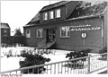
State medical practice (1984)
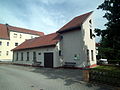
Martin Luther Chapel in Tettau (2014)


Population development
|
|
|
|
|
Territory of the respective year, number of inhabitants: as of December 31 (from 1991), from 2011 based on the 2011 census
politics
Community representation
The community council of Tettau consists of 10 community representatives and the honorary mayor. The local election on May 26, 2019 resulted in the following distribution of seats:
| Party / group of voters | Seats |
|---|---|
| Voting group economy, culture and sport | 6th |
| CDU | 3 |
| Individual applicant Dieter Fiedler | 1 |
mayor
- 1998–2003: Kurt Schmaler (CDU)
- 2003–2019: Siegmar Petrenz (Voting Group Economy, Culture and Sport)
- since 2019: Joachim Nitzsche (CDU)
Nitzsche was elected in the mayoral election on May 26, 2019 with no opposing candidate with 64.2% of the valid votes for a term of five years.
coat of arms
The coat of arms was approved on March 14, 1996.
Blazon : "In blue a golden tip, in it two blue wavy bars elevated by a blue water drop."
The coat of arms colors symbolize the bond with Upper Lusatia, whose coat of arms colors blue and gold were adopted. The water drop stands for the importance of the place in terms of water management.
Sights and culture

The Martin Luther Chapel, built in wood in 1954, was built in 1991 as a solid construction.
The Tettauer Oberwald is a natural monument, the Bleichplan biotope was created on the Grenzpulsnitz.
On June 23, 2013, the “foundation stone” for the lowest point in Upper Lusatia was inaugurated on the Elster Bridge between Lauchhammer-West and Schraden.
In summer there is a music festival in Tettau organized by the Tettau / Frauendorf Shawm Orchestra.
Economy and Infrastructure
Tettau is located in the drinking water protection area. There is a waterworks in the village, one of the largest in the GDR . Today it is the largest waterworks in Brandenburg.
- traffic
Tettau is on the K 6607 district road from Lauchhammer to Ortrand . The A 13 Berlin-Dresden runs east of Tettau (junction Ortrand ) and 4 km north of the federal highway 169 from Elsterwerda to Ruhland .
Personalities
- Heinrich Nicklisch (1876–1946), professor of business administration , born in Tettau. On July 19, 2009, on his 133rd birthday, a bronze plaque was unveiled at the house where he was born in the presence of his grandchildren.
Individual evidence
- ↑ Population in the State of Brandenburg according to municipalities, offices and municipalities not subject to official registration on December 31, 2019 (XLSX file; 223 KB) (updated official population figures) ( help on this ).
- ^ Service portal of the state administration Brandenburg. Tettau community
- ^ Historical municipality register of the state of Brandenburg 1875 to 2005. District Oberspreewald-Lausitz . Pp. 26-29
- ↑ Population in the state of Brandenburg from 1991 to 2015 according to independent cities, districts and municipalities , Table 7
- ^ Office for Statistics Berlin-Brandenburg (Ed.): Statistical report AI 7, A II 3, A III 3. Population development and population status in the state of Brandenburg (respective editions of the month of December)
- ^ Result of the local election on May 26, 2019
- ↑ Results of the local elections in 1998 (mayoral elections) for the Oberspreewald-Lausitz district ( Memento of the original from April 19, 2018 in the Internet Archive ) Info: The archive link was inserted automatically and has not yet been checked. Please check the original and archive link according to the instructions and then remove this notice.
- ↑ Local elections October 26, 2003. Mayoral elections , p. 28
- ↑ Brandenburg Local Election Act, Section 73 (1)
- ^ Result of the mayoral election on May 26, 2019
- ↑ Coat of arms information on the service portal of the state administration of Brandenburg
- ↑ Upper Lusatia is also Brandenburg . In: Lausitzer Rundschau from June 15, 2013
- ↑ Tettauer remind of Heinrich Nicklisch ( page no longer available , search in web archives ) Info: The link was automatically marked as defective. Please check the link according to the instructions and then remove this notice. . In: Lausitzer Rundschau from July 18, 2009
Web links
- Tettau website
- History of Tettau on the homepage of the Ortrand Office , accessed on May 7, 2010.
- Tettau in the Digital Historical Directory of Saxony
Altdöbern | Bronkow | Calau (Kalawa) | Frauendorf | Large meal | Großräschen (Rań) | Grünewald | Guteborn | Hermsdorf | Hohenbocka | Kroppen | Lauchhammer | Lindenau | Lübbenau / Spreewald (Lubnjow / Błota) | Luckaitztal | New Zealand (Nowa Jazorina) | Neupetershain (Nowe Wiki) | Outskirts | Ruhland | Schipkau | Schwarzbach | Schwarzheide | Senftenberg (Zły Komorow) | Tettau | Vetschau / Spreewald (Wětošow / Błota)