
Pianottoli-Caldarello
|
Pianottoli-Caldarello Pianottuli è Caldareddu |
||
|---|---|---|
|
||
| region | Corsica | |
| Department | Corse-du-Sud | |
| Arrondissement | Sartène | |
| Canton | Grand Sud | |
| Community association | South Corse | |
| Coordinates | 41 ° 30 ' N , 9 ° 3' E | |
| height | 0-1,321 m | |
| surface | 42.78 km 2 | |
| Residents | 912 (January 1, 2017) | |
| Population density | 21 inhabitants / km 2 | |
| Post Code | 20131 | |
| INSEE code | 2A215 | |

Pianottoli-Caldarello ( Corsican Pianottuli è Caldareddu ) is a municipality in the French department of Corse-du-Sud on the Mediterranean island of Corsica . The residents call themselves Pianottolais, Pianuttulacci and Caldariddacci .
geography
The municipality belongs to the canton of Figari in the arrondissement of Sartène and extends from the Mediterranean coast in the south to the Montagne de Cagna. The highest point with 1321 m is the Punta d'Ovace on the border with Sartène in the northwest. Other neighboring communities are Levie in the north, Figari in the east and Monacia-d'Aullène in the west.
history
In 1921 the municipality got its current name - Pianottoli-Caldarello.
Population development
| year | 1921 | 1962 | 1968 | 1975 | 1982 | 1990 | 1999 | 2008 | 2012 |
|---|---|---|---|---|---|---|---|---|---|
| Residents | 635 | 313 | 310 | 794 | 889 | 653 | 729 | 833 | 934 |
economy
Vineyards in Pianottoli-Caldarello are part of the wine-growing area around Figari , a sub-zone of the Vin de Corse appellation .
traffic
Figari Airport is about two kilometers to the east .
Others
There are caves in Pianottoli-Caldarello .
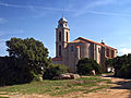
Church in Pianottoli-Caldarello
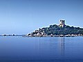
The Genoese Tower of Caldarello, Monument historique

The Mairie


Web links
Individual evidence
- ↑ Serveur de fiches - Géodésie. geodesie.ign.fr, accessed on September 14, 2015 (French).