
Olmeto
|
Olmeto Ulmetu |
||
|---|---|---|
|
||
| region | Corsica | |
| Department | Corse-du-Sud | |
| Arrondissement | Sartène | |
| Canton | Sartenais-Valinco | |
| Community association | Sartenais Valinco | |
| Coordinates | 41 ° 43 ' N , 8 ° 55' E | |
| height | 0-1,055 m | |
| surface | 43.82 km 2 | |
| Residents | 1,216 (January 1, 2017) | |
| Population density | 28 inhabitants / km 2 | |
| Post Code | 20113 | |
| INSEE code | 2A189 | |
 Olmeto |
||

Olmeto ( Corsican Ulmetu ) is a municipality in the French department of Corse-du-Sud on the Mediterranean island of Corsica . It belongs to the canton of Sartenais-Valinco . The residents call themselves Olmetain .
geography
The settlement area is about 360 meters above sea level and is affected by Route nationale 196 . The municipality borders the Mediterranean Sea to the south and is surrounded clockwise by Serra-di-Ferro , Sollacaro , Casalabriva , Petreto-Bicchisano , Santa-Maria-Figaniella , Fozzano , Viggianello and Propriano .
Population development
| year | 1962 | 1968 | 1975 | 1982 | 1990 | 1999 | 2008 | 2012 |
|---|---|---|---|---|---|---|---|---|
| Residents | 619 | 685 | 730 | 676 | 1019 | 1115 | 1216 | 1213 |
Attractions
- Dolmen Figa la Sarra, see also megaliths in Corsica
- Statue menhir
- Former Saint-Antoine convent
- Genoese tower Tour de la Calanca
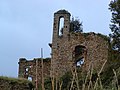
Remains of the Saint-Antoine convent

Genoese tower Tour de la Calanca


Personalities
- Colomba Carabelli , figure of Corsican contemporary history in the 19th century
- Paul Séverin Abbatucci , politician (1821–1888)
Web links
Commons : Olmeto - collection of images, videos and audio files