Route national 196
| Route Nationale 196 in France | ||||||||||||||||||||||||||||||||||||||||||||||||||||||||||||||||||||||||||||||||||
| N 196 | ||||||||||||||||||||||||||||||||||||||||||||||||||||||||||||||||||||||||||||||||||
| Basic data | ||||||||||||||||||||||||||||||||||||||||||||||||||||||||||||||||||||||||||||||||||
| Operator: | ||||||||||||||||||||||||||||||||||||||||||||||||||||||||||||||||||||||||||||||||||
| Overall length: | 130 km | |||||||||||||||||||||||||||||||||||||||||||||||||||||||||||||||||||||||||||||||||
|
Regions : |
||||||||||||||||||||||||||||||||||||||||||||||||||||||||||||||||||||||||||||||||||
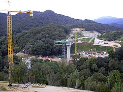
| Construction of a bridge on Route nationale 196, which was commissioned in 2008 | ||||||||||||||||||||||||||||||||||||||||||||||||||||||||||||||||||||||||||||||||||
|
Course of the road
|
||||||||||||||||||||||||||||||||||||||||||||||||||||||||||||||||||||||||||||||||||
The Route nationale 196 , or N 196 or RN 196 for short , is a French national road that was laid between Ajaccio and Bonifacio in 1836 . Its route was moved north around Ajaccio when the airport was built in 1978. An expressway was also created between Ajaccio and the airport, on which the national road was then laid. This road is to be used as a route territorial 40 in the future. Its length is 130 kilometers.
N 196a
The Route nationale 196 A , or N 196 A or RN 196 A for short , was a side branch of the N196, which from 1933 closed the N196 to the port in Propriano. It became Kommunalstrasse in 1973.
N 196b
The Route nationale 196 B , N 196 B or RN 196 B for short , was a branch of the N196, which from 1933 represented an alternative route for the N196 within Sartène. It became Kommunalstrasse in 1973.
N 196d
The Route Nationale 196 D , or N 196 D or RN 196 D for short , was a branch of the N196 that connected the N196 to Ajaccio Airport. Commissioned in 1957, it became Kommunalstrasse in 1973.
Web links
- Route nationale française on WikiSara, a list of all national roads (French)


