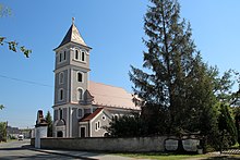
Przełęk
| Przełęk Preiland |
||
|---|---|---|

|
|
|
| Basic data | ||
| State : | Poland | |
| Voivodeship : | Opole | |
| Powiat : | Nysa | |
| Gmina : | Nysa | |
| Geographic location : | 50 ° 25 ′ N , 17 ° 20 ′ E | |
| Height : | 200-250 m npm | |
| Residents : | 570 (December 31, 2018) | |
| Postal code : | 48-303 | |
| Telephone code : | (+48) 77 | |
| License plate : | ONY | |
| Economy and Transport | ||
| Street : | Ext. 411 Nysa - Konradów | |
| Rail route : | Kędzierzyn-Koźle-Nysa | |
| Next international airport : | Wroclaw | |
Przełęk (German Preiland , 1945–1947 Przełęt ) is a village in the rural municipality of Nysa ( Neisse ) in Poland . It is located in the powiat Nyski (Neisse district) in the Opole Voivodeship .
geography
Geographical location
The street village of Przełęk is located in the southwest of the historical region of Upper Silesia . The place is about eight kilometers south of the municipality and the district town of Nysa and about 63 kilometers southwest of the voivodeship capital Opole .
Przełęk lies in the Nizina Śląska (Silesian Plain) within the Płaskowyż Głubczycki (Leobschützer Loesshügelland) . The village is located on the right bank of the Biała Głuchołaska ( Biele ). The place is on the Kędzierzyn-Koźle-Nysa railway line . Przełęk is located on Droga wojewódzka 411 Voivodeship Road .
Neighboring places
Neighboring towns of Przełęk are Podkamień ( Steinhübel ) in the north, Hajduki Nyskie ( Heidau ) in the north-east , Polski Świętów ( Polish bet ) and Markowice in the south, Iława ( Eilau ) and Morów ( Mohrau ) in the west and Biała Nyska ( Bielau ) in the north-west .
history
The place was first mentioned in 1256 as a prelude . An extended mention was made in 1284 as Prilanth . In the work Liber fundationis episcopatus Vratislaviensis from the years 1295-1305, the place is first mentioned as Morow . In 1311 it was mentioned as a prelant .
After the First Silesian War in 1742, Preiland and most of Silesia fell to Prussia . In 1784 a school was established in the village.
After the reorganization of the province of Silesia which belonged rural community Preiland from 1816 to district Neisse in the administrative district of Opole . In 1845 there was a Catholic branch church, a chapel, a Catholic school and 69 other houses in the village. In the same year, 465 people lived in Preiland, all of them Catholic. In 1847 a cotton mill was founded in the village by the merchant Robert Herber. In 1855 570 people lived in the village. In 1865 the place had 21 farms, 17 gardeners and 23 cottagers. The school was attended by 106 students in the same year. In 1874 the district of Bielau was founded, which consisted of the rural communities Bielau, Eilau, Mohrau, Preiland and Steinhübel and the manor districts of Bielau, Eilau, Mohrau, Preiland and Steinhübel. In November 1875, the Neisse – Ziegenhals line was opened, giving Preiland a connection to the rail network of the Upper Silesian Railway . In 1885 Preiland had 504 inhabitants.
In 1933 there were 537 people in Preiland and 541 in 1939. Until 1945 the place was in the district of Neisse .
In 1945 the place came under Polish administration and was initially renamed Przełęt , the population was expelled. In 1947 the place name was changed to Przełęk . In 1950 Przełęk came to the Opole Voivodeship. In 1999 the place came to the re-established Powiat Nyski .
Attractions
- The Roman Catholic Church of St. Nicholas (Polish Kościół św. Mikołaja ) was built in 1780 in the Baroque style. A chapel in the same place was mentioned as early as 1495. In 1638 this chapel was replaced by a stone structure. The church building has been a listed building since 1966.
- The memorial for the fallen of the First World War has been partially preserved.
- Wayside cross
societies
- Volunteer Fire Brigade OPS Przełęk
- Football club LKS Przełęk
Web links
Individual evidence
- ↑ Liczba mieszkańców w Gminie Nysa (Polish), Dec. 31, 2018, accessed on Nov. 29, 2019
- ↑ Liber fundationis episcopatus Vratislaviensis
- ↑ a b Johann Georg Knie : Alphabetical-statistical-topographical overview of the villages, towns, cities and other places of the royal family. Preuss. Province of Silesia. Breslau 1845, p. 510.
- ↑ a b Cf. Felix Triest: Topographisches Handbuch von Oberschlesien. Breslau 1865, p. 989.
- ^ Territorial district of Bielau
- ↑ AGoFF circle Neisse
- ^ Michael Rademacher: German administrative history from the unification of the empire in 1871 to the reunification in 1990. Neisse district (Polish Nysa). (Online material for the dissertation, Osnabrück 2006).
- ↑ Monument register of the Opole Voivodeship (Polish; PDF; 913 kB)


