Rusocin (Nysa)
| Rusocin Riemertsheide |
||
|---|---|---|

|
|
|
| Basic data | ||
| State : | Poland | |
| Voivodeship : | Opole | |
| Powiat : | Nysa | |
| Gmina : | Nysa | |
| Area : | 0.857 km² | |
| Geographic location : | 50 ° 30 ' N , 17 ° 25' E | |
| Height : | 180-220 m npm | |
| Residents : | 424 (December 31, 2018) | |
| Postal code : | 48-300 | |
| Telephone code : | (+48) 77 | |
| License plate : | ONY | |
| Economy and Transport | ||
| Street : | Ext. 406 Nysa - Włostowa | |
| Next international airport : | Wroclaw | |
Rusocin (German Riemertsheide , also Remertsheide ) is a village in the rural municipality of Nysa ( Neisse ) in Poland . It is located in the powiat Nyski (Neisse district) in the Opole Voivodeship .
geography
Geographical location
The street village of Rusocin is located in the southwest of the historical region of Upper Silesia . The place is about eight kilometers northeast of the municipality and the district town of Nysa and about 51 kilometers southwest of the voivodeship capital Opole .
Rusocin lies in the Nizina Śląska ( Silesian Plain ) in the border area of the Równina Wrocławska ( Wroclaw Plain ) to the Dolina Nysy Kłodzkiej ( Glatzer Neisse Valley ). The Voivodeship Road Droga wojewódzka 406 runs through the village . The Glatzer Neisse flows southeast of Rusocin .
Neighboring places
Neighboring places of Rusocin are Piątkowice ( Rotthaus ) in the east, Złotogłowice ( Groß Neundorf ) in the west and Prusinowice ( Waltdorf ) in the northwest .
history
The village was first mentioned in 1267 as Rinaczow . In the work Liber fundationis episcopatus Vratislaviensis from the years 1295-1305, the place is mentioned as Reywarczheide . In 1338 it was mentioned as Reuarsheyde . The village was also mentioned in documents in 1373 as Reynmartsheide and in 1378 as Reynfarczheide . In 1588 the village had 36 hooves.
After the First Silesian War in 1742, Riemertsheide and most of Silesia fell to Prussia . In 1791 the village including the parish church was destroyed by fire.
After the reorganization of the province of Silesia which belonged rural community Riemertsheide from 1816 to district Neisse in the administrative district of Opole . In 1845 there was a Catholic parish church, two chapels, a Catholic school, an Erbscholtisei, a distillery and 92 other houses in the village. In the same year 608 people lived in Riemertsheide, all of them Catholic. In 1855 there were 698 people living in the village. In 1865 there was a hereditary scholtisei , 28 farms, 16 gardeners and 41 cottagers in the village . From 1865–1873 Fort Rieglitz was laid out in the corridors of Rieglitz as a branch of the Neisse fortress. In 1874 the district of Lassoth was founded, which consisted of the rural communities of Lassoth, Nieder Jeutritz, Ober Jeutritz, Riemertsheide and Rothhaus and the manor districts of Lassoth and Rothhaus. In 1885 Riemertsheide had 725 inhabitants.
A new school building was built between 1905 and 1906. In 1925 the village school had 99 students. In 1933 there were 581 people in Riemertsheide, and 594 in 1939. Until 1945 the place was in the district of Neisse .
In 1945 the place came under Polish administration and was renamed Rusocin , the population was expelled. In 1950 Rusocin came to the Opole Voivodeship. In 1999 the place came to the re-established Powiat Nyski .
Attractions
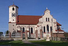
- The Roman Catholic Church of Clement (Polish Kościół św. Klemensa Rzymskiego ) was built between 1896 and 1897. The building replaced the church building built in 1791. The church building has been a listed building since 1966.
- Church cemetery
- Two-story brick school building
- Wayside chapel
societies
- Volunteer fire brigade OSP Rusocin
- Football club LZS Rusocin
Web links
Individual evidence
- ↑ Liczba mieszkańców w Gminie Nysa (Polish), Dec. 31, 2018, accessed on Nov. 29, 2019
- ↑ a b History of Rusocin (Polish)
- ↑ Liber fundationis episcopatus Vratislaviensis
- ↑ a b Johann Georg Knie : Alphabetical-statistical-topographical overview of the villages, towns, cities and other places of the royal family. Preuss. Province of Silesia. Breslau 1845, p. 547.
- ↑ a b c Cf. Felix Triest: Topographisches Handbuch von Oberschlesien. Breslau 1865, p. 989.
- ↑ Territorial District Lassoth / low Hermsdorf
- ↑ AGoFF circle Neisse
- ^ Michael Rademacher: German administrative history from the unification of the empire in 1871 to the reunification in 1990. Neisse district (Polish Nysa). (Online material for the dissertation, Osnabrück 2006).
- ↑ History of the Clement Church (Polish)
- ↑ Monument register of the Opole Voivodeship (Polish; PDF; 913 kB)


