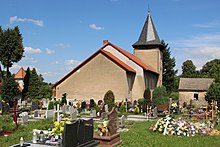
Konradów (Głuchołazy)
| Konradów Dürr Kunzendorf |
||
|---|---|---|

|
|
|
| Basic data | ||
| State : | Poland | |
| Voivodeship : | Opole | |
| Powiat : | Nysa | |
| Gmina : | Głuchołazy | |
| Geographic location : | 50 ° 18 ′ N , 17 ° 24 ′ E | |
| Height : | 320-400 m npm | |
| Residents : | 994 (March 31, 2011) | |
| Postal code : | 48-340 | |
| Telephone code : | (+48) 77 | |
| License plate : | ONY | |
| Economy and Transport | ||
| Street : | Ext. 411 Nysa –Konradów | |
| Next international airport : | Wroclaw | |
Konradów (German Dürr Kunzendorf , 1945–1947 Kończyce ) is a village in the rural community Głuchołazy (goat neck) in Poland . It is located in the powiat Nyski ( Neisse district ) in the Opole Voivodeship .
geography
Geographical location
The street village Konradów is located in the southwest of the historical region of Upper Silesia on the northern edge of the Zuckmanteler Bergland and on the border with the Czech Republic . The place is about two kilometers southeast of the municipality seat Głuchołazy ( goat neck ), about 20 kilometers south of the district town of Nysa and about 65 kilometers southwest of the voivodeship capital Opole .
The place is in the Sudety Wschodnie (Eastern Sudetes) within the Góry Opawskie (Zuckmanteler Bergland) . Konradów is located on the Kletnica , a right tributary of the Biała Głuchołaska ( Ziegenhalser Biele ).
Districts
Districts of Konrdadów are Kletnik ( Klettnig ), Kolonia Kaszubska ( Colony of Stones ), Skowronków ( Lerchenfeld ) and Starowice ( Vorwerk Dürr Kunzendorf ).
Neighboring places
Neighboring towns of Konradów are in the northwest of the municipality Głuchołazy ( goat neck ) , in the southeast Jarnołtówek ( Arnolsdorf ) and in the south Zlaté Hory ( Zuckmantel ).
history
The place was first mentioned in 1263 as villa Conradi . In 1284 the place was mentioned as Cunczendorf . In the Liber fundationis episcopatus Vratislaviensis from the years 1295-1305, the place is called "Cunczendorph".
In 1725 a school was established in the village. After the First Silesian War in 1742, Dürr Kunzendorf and most of Silesia fell to Prussia .
After the reorganization of the province of Silesia , the rural community Dürr Kunzendorf belonged to the district of Neisse in the administrative district of Opole from 1816 . In 1845 there was a Scholtisei , a castle, a Vorwerk, a Catholic school and 195 other houses in the village. In the same year, 1266 people lived in Dürr Kunzendorf, two of them Protestants. In 1855 there were 1032 people living in the village. In 1865 there was a free estate , 65 farmer, 22 gardener and 63 cottage industry jobs as well as a brewery, a distillery, three taverns and a water mill. In 1874 the district of Dürr Kunzendorf was founded, which consisted of the rural communities Dürr Kunzendorf and the manor district of Kunzendorf. In 1885 Dürr Kunzendorf had 1,108 inhabitants.
Most of the village buildings were destroyed in a flood in 1903. Then the German Empress Auguste Viktoria of Schleswig-Holstein-Sonderburg-Augustenburg visited the place. In 1933 there were 1170 people in Dürr Kunzendorf and 1260 in 1939. Until 1945 the place was in the district of Neisse .
In 1945 Dürr Kunzendorf came under Polish administration and was initially renamed Kończyce . In 1947 the place was renamed Konradów . From 1950 it belonged to the Opole Voivodeship and from 1999 to the re-established Powiat Nyski .
Attractions
- The Roman Catholic King Christ Church (Polish Kościół Chrystusa Króla ) was built in 1937.
- The Dürr Kunz village castle was built in the first half of the 18th century.
- Monument in memory of the visit of the German Empress in 1903
societies
- Football club GKS II Polkon Konradów-Głuchołazy
Web links
Individual evidence
- ^ CIS 2011: Ludność w miejscowościach statystycznych według ekonomicznych grup wieku (Polish), March 31, 2011, accessed on December 29, 2019
- ↑ Liber fundationis episcopatus Vratislaviensis
- ↑ a b Johann Georg Knie : Alphabetical-statistical-topographical overview of the villages, towns, cities and other places of the royal family. Preuss. Province of Silesia. Breslau 1845, p. 336.
- ↑ a b Cf. Felix Triest: Topographisches Handbuch von Oberschlesien. Breslau 1865, p. 1021.
- ^ Territorial district of Dürr Kunzendorf
- ↑ AGoFF circle Neisse
- ^ Michael Rademacher: German administrative history from the unification of the empire in 1871 to the reunification in 1990. Neisse district (Polish Nysa). (Online material for the dissertation, Osnabrück 2006).
- ↑ a b Gmina Głuchołazy Monument Register (Polish)


