Röttenbach (district of Roth)
| coat of arms | Germany map | |
|---|---|---|

|
Coordinates: 49 ° 9 ' N , 11 ° 2' E |
|
| Basic data | ||
| State : | Bavaria | |
| Administrative region : | Middle Franconia | |
| County : | Roth | |
| Height : | 372 m above sea level NHN | |
| Area : | 21.66 km 2 | |
| Residents: | 3145 (Dec. 31, 2019) | |
| Population density : | 145 inhabitants per km 2 | |
| Postal code : | 91187 | |
| Area code : | 09172 | |
| License plate : | RH, HIP | |
| Community key : | 09 5 76 141 | |
| Community structure: | 5 parts of the community | |
| Address of the municipal administration: |
Rathausplatz 1 91187 Röttenbach |
|
| Website : | ||
| Mayor : | Thomas Schneider ( Free Voters e.V. ) | |
| Location of the municipality of Röttenbach in the district of Roth | ||
Röttenbach is a municipality in the Central Franconian district of Roth .
geography
location
Röttenbach is located in the Franconian Lake District , around 40 kilometers south of Nuremberg .
The eponymous Röttenbach flows through the place. It rises five kilometers east in the Irlespan forest and flows northwest of Röttenbach into the Swabian Rezat . The Spalter hill country rises to the west of Röttenbach .
The neighboring communities are Pleinfeld , Heideck , Georgensgmünd and Spalt .
Community structure
The municipality has five officially named municipal parts (the type of settlement is given in brackets ):
- Mühlstetten ( Kirchdorf )
- Niedermauk (Kirchdorf)
- Oberbreitenlohe ( village )
- Röttenbach ( parish village )
- Subreitlohe (village)
history
Until the church is planted
Röttenbach was probably built around the year 1000 as a clearing settlement and was first mentioned around 1200 when Bishop Otto consecrated a St. Mary's Church. The Immediatrittergut of the bishopric of Bamberg , which from 1500 was in the Franconian Empire , came to Prussia immediately after the secularization in 1803 in favor of Bavaria in the Prussian-Bavarian mainland comparison . In the Peace of Tilsit in 1807 it fell to France with the Prussian Principality of Bayreuth and came to the Kingdom of Bavaria with the Treaty of Paris in 1810 .
With the administrative reforms in Bavaria with the community edict of 1818, the community with the community part of Niedermauk was created.
Koenigsstrasse
Around 1860, the so-called Königsstraße was built as a trade route, today's Bundesstraße 2 .
Incorporations
On January 1, 1975, the previously independent municipality of Mühlstetten was incorporated into the municipality of Röttenbach.
politics
Municipal council
The town council of Röttenbach has 14 members.
| CSU | SPD | FW | total | |
| 2014 | 7th | 2 | 5 | 14 seats |
mayor
The first mayor of the municipality of Röttenbach has been Thomas Schneider (Free Voters) since May 1996, Anton Schmidpeter from the CSU is deputy, and Stephanie Schubert from the SPD is the third mayor.
badges and flags
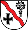
The municipality of Röttenbach has had a coat of arms since 1982.
|
Blazon : "In silver a red diagonal wave bar , above the curvature of a black bishop's staff , below a floating black paw cross "
Black-white-red municipal flag |
|
| Justification of the coat of arms: The coat of arms of Röttenbach indicates the two rulers who are important for the community. The crosier is taken from the Hochstift coat of arms of Eichstätt. The paw cross comes from the coat of arms of the Teutonic Order and commemorates the rule of the Teutonic Order Coming Ellingen in Röttenbach from the 13th century until the end of the Old Kingdom. The red inclined shaft Bach is talking for the place name, the "red river" means. |
Architectural monuments
- Old church in Röttenbach, Deutschherrnstrasse
- Chapel in Mühlstetten, Röttenbacher Strasse
- Church of St. Sebastian in Niedermauck, Gothic (14th century), on a hill in the middle of the village, high altar with three Gothic statues (1520); on the left side altar Madonna from 1370 in a baroque shrine from 1780; Copy of the Albrecht Dürer painting Madonna with the Pear, painted around 1600
traffic
Bundesstraße 2, which formerly ran through the town, has been led around it in the east since 2007, which is a significant relief. Bus connections go to Roth and to the Mühlstetten train station, two kilometers away.
literature
- Johann Kaspar Bundschuh : Röttenbach . In: Geographical Statistical-Topographical Lexicon of Franconia . tape 6 : V-Z . Verlag der Stettinische Buchhandlung, Ulm 1804, DNB 790364328 , OCLC 833753116 , Sp. 878 ( digitized version ).
Web links
- Röttenbach (district of Roth): Official statistics of the LfStat (PDF; 1.2 MB)
- Community website
- Röttenbach in the Topographia Franconiae of the University of Würzburg , accessed on September 23, 2019.
Individual evidence
- ↑ "Data 2" sheet, Statistical Report A1200C 202041 Population of the municipalities, districts and administrative districts 1st quarter 2020 (population based on the 2011 census) ( help ).
- ^ Community Röttenbach in the local database of the Bavarian State Library Online . Bayerische Staatsbibliothek, accessed on September 1, 2019.
- ↑ http://www.roettenbach.de/index.php?id=121,26&suche=
- ^ Federal Statistical Office (ed.): Historical municipality directory for the Federal Republic of Germany. Name, border and key number changes in municipalities, counties and administrative districts from May 27, 1970 to December 31, 1982 . W. Kohlhammer, Stuttgart / Mainz 1983, ISBN 3-17-003263-1 , p. 732 .
- ↑ http://www.wahlen.bayern.de/kw2014/gderaete-mfr-576.htm
- ↑ Entry on the coat of arms of Röttenbach (Roth district) in the database of the House of Bavarian History
- ↑ Röttenbach. In: Kommunalflaggen.eu. Retrieved June 17, 2020 .


