
Rehoboth
| city Rehoboth ǃAnis ( khi )
|
|||
|---|---|---|---|
|
|||
 |
|||
| motto | Pro Bono Omnium (for the good of all) formerly: Groei in Geloof ( Growing in Faith) |
||
| Basic data | |||
|
Population Area Population Density |
28,800 ( 2010 census ) 639 km² 44.4 inhabitants / km² |
||
|
State Region Constituency |
Namibia Hardap Rehoboth City (West) Rehoboth City (East) |
||
| Establishment date | 1871 | ||
|
License plate phone code |
R 62 |
||
| Website | rehobothtowncouncil.org | ||
 |
|||
|
Political data
Chief Executive Officer : Simeon Kanime (since August 1, 2019) Last election: 2015 Next election: 2020 City administration address: |
|||
|
Geographical data
Geographical coordinates : 23 ° 19 '0 "S, 17 ° 4' 54" E Height : 1,385 m |
|||


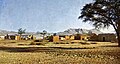
Rehoboth is a city and regional center in the Hardap region in Namibia . The city is about 85 kilometers south of the Namibian capital Windhoek and directly on the B1 . Rehoboth was founded in 1871 and named after the biblical city of Rechovot (in Israel ). Rehoboth today has 28,800 inhabitants.
history

Rehoboth was founded in 1871 as the tribal seat of the so-called Rehoboth Baster (descendants from mixed marriages between Nama (women) and Boer immigrants from the Cape region ( South Africa )) under their captain Hermanus van Wyk and was intended as a buffer between those who were in constant feud Serving Nama from Hoachanas and Herero from Okahandja. The basters who settled here called themselves Rehoboth Baster from then on (the term “Baster” being understood as an honorary title). Due to its exposed location between these two "superpowers" in what was then South West Africa, Rehoboth was repeatedly the scene of bloody conflicts, looting and destruction, especially after the Swartbooi Nama tribe had settled here.
After Germany took possession of South West Africa and the establishment of the German South West Africa colony , the Rehoboth Baster were one of the first tribes to conclude protection and assistance agreements with the German protecting power (1885) and actively supported them in the desired pacification of the troubled country from Baster associations. At the beginning of the First World War , a Baster volunteer company was set up in Rehoboth under German leadership, but with the express restriction that it could not be used against whites. In return for their loyal attitude, the Rehoboth Baster were granted limited autonomy rights by the German colonial administration. After the Baster rioted against German tutelage shortly before the end of the war in 1915, the South African mandate administration continued to grant them these autonomy rights, but they were revoked again in 1925. The Basters rose up against this measure, but gave in when the South Africans threatened to bomb Rehoboth.
Rehoboth and the Kapsteine of the Rehoboth Baster lost their special rights in the course of independence. The Rehoboth area was divided into three different administrative constituencies, although initially the League of Nations and later also the UN recognized Rehoboth's quasi independent rights . Before Namibian independence, the Basters considered joining the South African Union in order to maintain their independence. In the course of the political upheavals in South Africa, however, this project could not be pursued any further.
Rehoboth was not directly accessed by rail for cost reasons. The Windhoek – Keetmanshoop railway ran past the city for around 12 kilometers. After protests by the city tour, the state built a 60 cm narrow-gauge tram line from the train station to the center of the town. The connecting railway was rented and operated by a Mr. Brauer. Rail operations began on January 15, 1913 and abandoned in the early 1950s.
Local politics
The following official final result was determined in the 2015 local elections .
| Political party | be right | Share of votes | Seats |
|---|---|---|---|
| SWAPO | 4519 | 53.8% | 4th |
| UPM | 3101 | 36.9% | 3 |
| DTA | 482 | 5.7% | 0 |
| RDP | 179 | 2.1% | 0 |
| UDF | 99 | 1.2% | 0 |
| All in all | 8390 | 100% | 7th |
Economy and Transport

Due to its central location, Rehoboth has good transport connections and a relatively healthy and well-mixed economic structure. In addition to the railway line operated today by TransNamib , the national road B1 runs through Rehoboth and this is where the main road C24 and main road C25 from the Namib-Naukluft National Park and Omaheke meet . Rehoboth train station is located 12 km east of the village.
There are seven elementary schools, two high schools and a technical college, as well as a hospital and the Rehoboth Chamber of Commerce . Because of its rich history, Rehoboth has 72 churches, a relatively high number for the size of the city. Rehoboth is also proud of its mineral bath, which encourages many visitors from near and far to take a cure. The history of the city is richly documented in the Rehoboth Museum .
To the west, near the city, is the Oanob Dam , which supplies the people of Rehoboth with water.
Educational institutions
Elementary schools
- Groendraai Primary School
- Herman Schoer Primary School
- JTL Beukes Primary School
- JW Mouton Primary School
- Mauheus Hansen Primary School
- Origo Primary School
- Petrus Vries Primary School
- Ruimte Primary School
- Schlim Primary School
- St. Joseph's Primary School ( RKK Namibia )
- St. Mary's Primary School
- Tsumis Farm Primary School
- Vooruitsig Primary School
- Witkop Primary School
- Witkrans Primary School
High schools
- Dr. Lemmer High School
- M&K Gertze High School
- Pioneer Junior Secondary School
- Rehoboth High School
- Rehoboth Junior Secondary School
sons and daughters of the town
- Henrico Botes (* 1979), Namibian football player
- Brian Brendell (* 1986), Namibian soccer player
Town twinning
|
gallery

Rehoboth from a bird's eye view (2017)

Oanob Reservoir and Recreation Area, west of Rehoboth
Rehoboth, view of the German station, around 1910


Web links
- Rehoboth Community Trust (English)
- Rehoboth Basters (English)
- Rehoboth Museum (English)
Individual evidence
- ↑ a b c d Namibia 2011 Population and Housing Census Preliminery Results. Namibia Statistics Agency, April 2012, accessed May 9, 2012
- ^ Rehoboth on a map from the time of German South West Africa
- ↑ Official election results of the regional and local elections 2015, ECN, December 4, 2015 ( Memento of December 10, 2015 in the Internet Archive ) (PDF; 150 kB)
- ↑ http://www.rcchurch.na/keetmanshoop/schools/rehoboth-ps.htm
- ↑ New town twinning in prospect. Allgemeine Zeitung, October 24, 2011
_(14580963919).jpg)
Coordinates: 23 ° 19 ′ S , 17 ° 5 ′ E