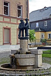
Harra
|
Harra
Rosenthal am Rennsteig municipality
|
|
|---|---|
| Coordinates: 50 ° 25 ′ 4 ″ N , 11 ° 41 ′ 1 ″ E | |
| Height : | 444 m above sea level NHN |
| Area : | 14 km² |
| Residents : | 828 (December 31, 2017) |
| Population density : | 59 inhabitants / km² |
| Incorporation : | 1st January 2019 |
| Postal code : | 07366 |
| Area code : | 036642 |
|
Location of Harra in the Saale-Orla district
|
|
Harra is a district of the municipality of Rosenthal am Rennsteig in the south of the Saale-Orla district in Thuringia .
Geography and geology
The average altitude for the district of Harra is 444 m above sea level. NN specified. The place is at the end of the Bleiloch reservoir on the Saale . The district covers 1,438 ha with the districts and is one of the foothills of the Thuringian Slate Mountains . It is almost completely surrounded by forest.
Neighboring places
Adjacent villages are Birkenhügel , Blankenberg , Blankenstein , Pottiga , Schlegel and the town of Bad Lobenstein in the Saale-Orla district and the town of Lichtenberg in the Bavarian district of Hof . In the vicinity of Harra is the desert of Absang , where there was a Reussian Vorwerk in the 19th century, the inhabitants of which were parish to Harra.
Nickname
The inhabitants are jokingly Harcher Leingstamauser (Harraer grave stone Mauser) called .

history
On April 22nd, 1232, Harra was first mentioned in a document. It is known that Harra was the knight seat of Albert von Harra. Hence the name, they say.
On August 14, 1905, the school was inaugurated, and was taught until 1991.
On January 1, 2019, the municipality of Harra with its districts of Kießling and Lemnitzhammer , which are located two kilometers away to the southwest and north, as well as six other municipalities from the dissolved Saale-Rennsteig administrative community merged to form the unitary municipality of Rosenthal am Rennsteig .
Harra battle
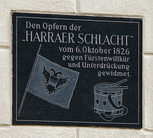
The Harra battle was a bloody confrontation on October 6, 1826. Farmers from Harra and other villages and troops of Prince Heinrich LXXII met. on each other.
prehistory
As early as March 31, 1819, the homeowners in the Principality of Reuss-Lobenstein were asked to "voluntarily" join the Magdeburg Fire Insurance Institute. This request was largely ignored because the prevailing opinion was that the construction of the houses meant that fires were hardly to be feared. On August 24, 1824, all homeowners were finally obliged to join. As in the run-up, it was evidently neglected to convey the advantages of such an insurance to the residents.
The battle"
Various briefings and letters to and from the state government and Heinrich LXXII. themselves did not lead to any result. The denied insurance premiums were collected by execution .
In order to prevent the impending seizure by force, farmers from the town and some surrounding villages gathered in Harra. Thereupon Heinrich sent LXXII. two military companies to Harra. Finally, on October 6, 1826, the unarmed but excited farmers and soldiers faced each other in today's village square in Harra. The invitation to part was unsuccessful. The military then opened fire for reasons unknown.
Seventeen people were killed in the attack and several were seriously wounded.
Aftermath
Some Bavarian farmers involved turned to the Archbishop of Bamberg , so that the matter came before the Federal Assembly . A commission of inquiry was sent to Lobenstein-Ebersdorf. The result of the investigation was not disclosed. The person responsible for the fire order could apparently not be determined.
In the 1980s, a plaque commemorating the battle was attached to the former restaurant "Eintracht" on the village square, which is still there today. The building now serves as a residential building.
Manor Harra
The manor Harra was a great diet capable manor . The patrimonial jurisdiction in the form of inheritance jurisdiction over his possessions in Harra, Kiessling , Schlegel and Seibis was connected with the possession of the manor . At the end of the Middle Ages the estate belonged to the von Blankenberg family . In 1554 the estate was divided. Now there was the lower and the upper Harra estate. There was also the manor Kießling which was connected to the manor Harra. In 1576 the von Reitzenstein family acquired the Kießling manor, in 1582 and 1608 they also acquired the lower and upper Harra manors. In 1641 they sold the upper estate to the von Watzdorf family , who sold it on to von Draxdorf in 1663 . The lower estate and the manor Kießling were sold to Muffel von Ermreuth in 1679 and 1680 .
In 1688 the von Watzdorf family again acquired the Kießling manor, and in 1692 also the two estates in Harra. In 1700 the three Gütter came into the possession of the wife of Heinrich XVII. (Reuss-Lobenstein) and 1712 to the Counts of Gleichen and Hatzfeld . In 1721 Reuss younger line became the owner again and the goods became Kammergut. The lower jurisdiction continued to exist, but was perceived by the Office Lobenstein . Jurisdiction was abolished in 1851 and passed to the state.
During the property dispute between the Reuss People's State and the Princely House, the property became the property of the People's State. He sold the state property in 1926 in connection with the construction of the Saale dam to the stock corporation "Obere Saale".
Population development
Development of the population (from 1994: as of December 31) :
|
|
|
|
|
Data source from 1994: Thuringian State Office for Statistics
Historical monuments
Prisoners on a death march from Buchenwald to Flossenbürg concentration camp , who were driven through the village, found their grave in the village cemetery after they had been murdered by SS men . Since 1969 a memorial stone commemorates the victims of fascism on Schillerplatz .
traffic
The Oberland railway line Triptis-Blankenstein (part of the railway line Triptis-Marxgrün ) with the Harra stop runs through Harra . There is also the Harra Nord stop nearby , which is mainly for tourist reasons. For passenger traffic, the route is served every two hours (as of 2012) by the Erfurt-Bahn trains of the Sormitztalbahn from Saalfeld via Unterlemnitz to Blankenstein .
In addition, the L 2372 runs through the village of Bad Lobenstein, which joins Landesstraße 1093 in Blankenstein .
Web links
Individual evidence
- ^ Wolfgang Kahl : First mention of Thuringian towns and villages. A manual. 5th, improved and considerably enlarged edition. Rockstuhl, Bad Langensalza 2010, ISBN 978-3-86777-202-0 , p. 110.
- ↑ History of Harra ( Memento of the original from March 1, 2012 in the Internet Archive ) Info: The archive link was inserted automatically and has not yet been checked. Please check the original and archive link according to the instructions and then remove this notice. on the Harra Municipality website; Retrieved August 9, 2011.
- ↑ Thuringian Law and Ordinance Gazette No. 14/2018 p. 795 ff. , Accessed on May 20, 2019
- ↑ Gottfried Drescher: The fire extinguishing system in the Blankenstein community through the ages . Website of the Blankenstein volunteer fire brigade; Retrieved October 2, 2012
- ↑ The ruler of a small state . In: The Gazebo . Issue 38, 1866, pp. 592 ( full text [ Wikisource ]). |
- ^ Rudolf Diezel: Overview of the holdings of the state archive Greiz (= publications of the Thuringian state main archive Weimar. 7, ISSN 0435-6918 ). Böhlau, Weimar 1963, pp. 115–116.
- ↑ Thuringian Association of the Persecuted of the Nazi Regime - Association of Antifascists and Study Group of German Resistance 1933–1945 (Ed.): Local history guide to sites of resistance and persecution 1933–1945. Volume 8: Thuringia. VAS - Verlag für Akademische Schriften, Frankfurt am Main 2003, ISBN 3-88864-343-0 , p. 222.


