Rode (Frieda)
|
Rode Oberlauf: Wiesenbach (more rarely also: light mill) |
||
|
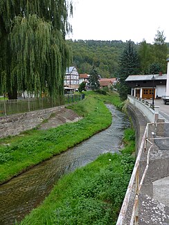
Course of the Rode in Sickerode |
||
| Data | ||
| Water code | DE : 41786 | |
| location | Eichsfeld district , Thuringia , Germany | |
| River system | Weser | |
| Drain over | Frieda → Werra → Weser → North Sea | |
| source | northern outskirts of Schwobfeld 51 ° 17 '26 " N , 10 ° 5' 43" E |
|
| Source height | approx. 430 m above sea level NN | |
| muzzle | in the municipality of Geismar in the Frieda coordinates: 51 ° 17 '26 " N , 10 ° 5' 47" E 51 ° 17 '26 " N , 10 ° 5' 47" E |
|
| Mouth height | approx. 194 m above sea level NN | |
| Height difference | approx. 236 m | |
| Bottom slope | approx. 25 ‰ | |
| length | 9.3 km | |
| Catchment area | 29 km² | |
| Communities | Schwobfeld , Armaments , Wiesenfeld , Sickerode , Geismar | |
The Rode is a right-hand or northern tributary of the Frieda in the Eichsfeld district in northwest Thuringia ( Germany ). On the upper reaches near Wiesenfeld it is also called Wiesenbach .
course
The Rode rises in several spring arms near Schwobfeld in Obereichsfeld and in the Eichsfeld-Hainich-Werratal Nature Park . In the south-easterly direction of flow it touches the southern outskirts of Armaments, then changes its direction to the south-west. After it has taken up the Hesselbach near Wiesenfeld, it flows again in a south-easterly direction through Sickerode to the confluence with the Frieda north of Großtöpfer , a district of Geismar.
Together with the Rosoppe , which flows approximately 300 m upstream , they form the northern fan of the Frieda catchment area. Both rivers drain and shape the landscape of the Rosoppe-Frieda hill country within the south dike field.
Tributaries
The following streams flow to the Rode:
- nameless brook (left), coming from Lehna
- Hesselbach (right), flows into Wiesenfeld
- Hühnerbach (right), coming from Volkerode
- Erdenbach (right), flows into the Rode in Sickerode.
geology
The source area is located on the edge of the Obereichsfelder Muschelkalkplatte between the Rachelsberg (523.2 m) and the Höheberg . The entire course of the river lies in the northwestern part of the Eichenberg – Gotha – Saalfeld fault zone . The Rode valley separates the Misseröder limestone ridge in the east from the red sandstone roofing of the Gobert in the west.
Watermills
In the past, numerous water mills were operated on the Rode :
- Atzmühle south of armor
- Light mill near Wiesenfeld
- Spitz, Ober and Thormühle in Sickerode.
Origin of name
Rode actually refers to land that has been cleared. The course of the river near Wiesenfeld is mentioned for the first time in 1610 as Wiesenbach (or Wisentbach) and in Middle High German probably denotes a brook where bison (or bison ox) came to drink.
Individual evidence
- ↑ a b Map services of the Federal Agency for Nature Conservation ( information )
- ↑ Thuringian State Institute for the Environment (ed.): Area and water code index and map. Jena 1998; 26 pp.
- ↑ Hydrogeological map of Thuringia from the Thuringian State Institute for Environment and Geology (PDF; 4.37 MB) ( Even finer maps are available for each district .)
- ↑ Erhard Müller: The place names of the district of Heiligenstadt. Heilbad Heiligenstadt 1989, p. 49 and 55
