
Sainte-Lizaigne
| Sainte-Lizaigne | ||
|---|---|---|
.svg)
|
|
|
| region | Center-Val de Loire | |
| Department | Indre department | |
| Arrondissement | Issoudun | |
| Canton | Levroux | |
| Community association | Pays d'Issoudun | |
| Coordinates | 47 ° 0 ′ N , 2 ° 1 ′ E | |
| height | 115-171 m | |
| surface | 26.36 km 2 | |
| Residents | 1,176 (January 1, 2017) | |
| Population density | 45 inhabitants / km 2 | |
| Post Code | 36260 | |
| INSEE code | 36199 | |
| Website | http://www.saintelizaigne.fr/ | |

Sainte-Lizaigne is a French commune with 1,176 inhabitants (as of January 1 2017) in the department of Indre in the Region Center-Val de Loire ; it belongs to the Arrondissement Issoudun and the Canton Levroux (until 2015: Canton Issoudun-Nord ). The inhabitants are called Lizigniens .
geography
Sainte-Lizaigne is located on the Théols River . Sainte-Lizaigne is surrounded by the neighboring communities of Diou in the north, Migny in the east, Saint-Georges-sur-Arnon in the east and south-east, Issoudun in the south, Les Bordes in the south and west and Paudy in the west and north-west.
Population development
| year | 1962 | 1968 | 1975 | 1982 | 1990 | 1999 | 2006 | 2013 |
| Residents | 895 | 821 | 816 | 1.002 | 1.109 | 1,160 | 1,212 | 1,211 |
| Source: Cassini and INSEE | ||||||||
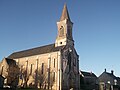
Attractions
- Notre-Dame-de-Lourdes church
- Sainte-Lizaigne church from 11th / 12th centuries century
Notre-Dame-de-Lourdes church

Sainte-Lizaigne Church
.jpg)

Web links
Commons : Sainte-Lizaigne - Collection of images, videos and audio files