
Dun-le-Poëlier
| Dun-le-Poëlier | ||
|---|---|---|
|
||
| region | Center-Val de Loire | |
| Department | Indre | |
| Arrondissement | Issoudun | |
| Canton | Valençay | |
| Community association | Chabris-Pays de Bazelle | |
| Coordinates | 47 ° 12 ' N , 1 ° 46' E | |
| height | 87-140 m | |
| surface | 22.56 km 2 | |
| Residents | 426 (January 1, 2017) | |
| Population density | 19 inhabitants / km 2 | |
| Post Code | 36210 | |
| INSEE code | 36068 | |
 Town hall (Mairie) of Dun-le-Poëlier |
||

Dun-le-Poëlier is a French municipality with 426 inhabitants (as of January 1 2017) in the department of Indre in the Region Center-Val de Loire ; it belongs to the Arrondissement of Issoudun and the Canton of Valençay (until 2015: Canton Saint-Christophe-en-Bazelle ). The inhabitants are called Dunois .
geography
Dun-le-Poëlier is located around 50 kilometers west-northwest of Bourges and 44 kilometers north-northeast of Châteauroux am Fouzon . Neighboring communities of Dun-le-Poëlier are Chabris in the north and north-west, La Chapelle-Montmartin in the north and north-east, Anjouin in the east, Bagneux in the south, Saint-Christophe-en-Bazelle in the south-west and Sembleçay in the west.
history
| year | 1962 | 1968 | 1975 | 1982 | 1990 | 1999 | 2006 | 2013 |
| Residents | 676 | 593 | 576 | 523 | 496 | 457 | 484 | 459 |
| Source: Cassini and INSEE | ||||||||
Attractions
- Saint-Hilaire church
- Saint Vincent Priory
- Fins Castle, domain from the 17th / 18th centuries century
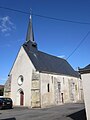
Saint-Hilaire church

Priory


Web links
Commons : Dun-le-Poëlier - collection of images, videos and audio files