San Cristóbal (Buenos Aires)
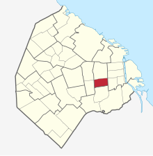
San Cristóbal is a district of the Argentine capital Buenos Aires . It has 49,986 inhabitants (as of 2001) on an area of 2.1 km² . The population density is 23,803 inhabitants / km² (the average in Buenos Aires is 15,200 / km²).
The district is bordered by the streets Av. Independencia , Av. Entre Ríos, Av. Juan de Garay and Sánchez de Loria.
description
San Cristóbal is located in the east of the city, near the old town. Parts of the district lie within the city limits drawn by Juan de Garay at the end of the 16th century. In 1869, San Cristóbal, together with San Telmo and Balvanera , received parish status in the course of a reorganization of the parishes. A census at the time showed 3,171 residents in 392 houses. In 1887, just 18 years later, there were already 37,000 residents and 3,200 houses. A third of these residents were foreigners.
On January 7, 1919, the police took action against striking workers in a metal factory in the district, killing four workers. The factory was at the intersection of La Rioja and Cochabamba. The crackdown on the strike is still known today as “Semana Trágica” (Tragic Week) or “Red January”, an allusion to both the color of blood and the “color” of Marxists and anarchists. The strike itself is seen today as the opening of the labor movement in Argentina.
The Santa Lucia Eye Clinic was opened in San Cristóbal in 2000. One of the district's educational institutions is the Instituto Nuestra Señora Del Huerto on Av. Independencia, at the corner of Rincon Street and Estados Unidos Street. There is also the private college “Instituto Rosa Anchorena de Ibañez” in Av. Constitución.
Web links
Coordinates: 34 ° 38 ′ S , 58 ° 24 ′ W


