Schwarzach (Isel)
The Schwarzach is a river in Austria ( East Tyrol ). The Schwarzach rises in the Schwarzachtal below the Schwarzachkees at an altitude of 2,480 meters and then flows through the valley to the confluence of the Schwarzach with the Arventalbach ( Arvental ). Here the Schwarzach makes its way through the Defereggental and the communities of St. Jakob , St.Veit and Hopfgarten in Defereggen , until the Schwarzach finally flows into the Isel from the right below Huben at an altitude of 800 meters . The Schwarzach thus overcomes a height of 1680 meters from the origin to the mouth and has a total length of 42.49 kilometers. On its way the Schwarzach with its tributaries absorbs a total of 34 bodies of water and drains a catchment area of 321.46 km².
history
The Schwarzach comes into the light of written history early and is already in 1048 in a diploma of Emperor Heinrich III. for the bishopric of Brixen and its Pustertal forest and wild ban rights as part of a detailed boundary description of the episcopal rights as "Swarzenbahc" attested.
geography
geology
In most areas the Schwarzach crosses old crystalline zones ( biotite slate ). In the upper reaches at the mouth of the Arvenbach , the Schwarzach crosses a narrow band of metamorphic limestone and dolomite from the Matreier zone. At Bruggen, the Schwarzach again cuts through a zone of granite-like intrusive rock ( tonalite ). However, downstream from the Patscher Alm to the mouth of the river into the Isel, the flatter valley stretches are covered by sand and gravel .
course
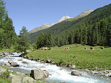
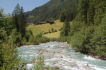
The Schwarzach rises at an altitude of 2,480 meters at the head of the Schwarzach Valley . The Schwarzach in the upper reaches is fed by the slopes of the numerous 3000 m peaks such as the Jagdhausspitze, Glockhaus ,akenboonspitze, Rötspitze (3,496 m), Daberspitze and Rotenmankogel. Between the Rötspitze and Daberspitze lies the Schwarzachkees, which with its meltwater also contributes to the formation of the Schwarzach. Below the origin, leveling and smaller gradients alternate at short intervals in the upper course. In widening areas, the river bed fills the entire valley floor in parts. Below the Jagdhausalmen , the Schwarzach finally takes on the Arventalbach . Here the Schwarzach crosses the limestone of the Matreier Zone, which can be seen from the deeply cut erosion channels on the slopes of the Schwarzach valley. As a result, the Schwarzach flows through a V-valley ( Kerbtal ) and passes the alpine pastures of the upper Defereggental . After the Seebachalmen and the Oberhausalm, the Schwarzach passes a stretch of gorge and finally reaches the Patscher Alm, from where it flows through a valley with a wide base and steep slopes to the Katzleiterbrücke. Between Erlsbach and Mariahilf there is another gorge stretch, in which the bottom remains relatively wide in places and small gravel banks can develop in places . Finally the Schwarzach reaches the valley widening of St. Jakob , where the debris cone of the Trojer Almbach , on which the village is located, pushes the Schwarzach to the right edge of the valley. Below the village, the river flows through a wide, flat area (long shrubs) of a former lake and then passes a ravine-like narrowing before it is thrown to the right side of the valley by the alluvial cone of the Feistritzbach near Bruggen. As a result, the Schwarzach leveling passes in the areas of Görtschach- St.Veit , Plon and Hopfgarten , which are separated from each other by short valley narrowings. After Hopfgarten, the valley narrows, whereby the route in this area is characterized by large cracks and material loads from the steep, left valley flank. Then the valley opens again at Döllach and finally turns into a longer stretch of gorge (“Deferegger Klamm”) until the Schwarzach finally flows into the Isel below Huben near Greil .
environment
fauna and Flora
In the area of origin, alpine lawn communities and dwarf shrub heaths accompany the course of the Schwarzach. As far as the Patscher Hut, there are more alpine pastures in the expanded valley areas . Larch - stone pine forests as well as pure stone pine stands in the upper reaches, especially in the slopes of the valley (Oberhauser stone pine forest). To the east of St. Jakob there are also extensive moor areas in the area of long shrubs . In the subsequent leveling areas of the valley areas there are mainly agricultural areas, but in places there are also remains of gray alder alluvial forest . These can reach far up into the valley flanks on cones of debris from feeders and along erosion channels. The gorge sections in the lower reaches ("Defregger Klamm"), on the other hand, are partly overgrown by remarkable deciduous forests rich in elm and linden .
Bank condition and building measures
In the upper reaches of Mariahilf, the Schwarzach has largely been preserved in natural stretches where there are only selective barriers. In contrast, with a few exceptions, the middle and lower reaches of the river are secured by block stone barriers, with the left bank usually having a higher level of barriers. The bank protection in the middle course serves primarily to protect agricultural areas and the Defereggentalstraße, which is partly close to the bank on the left bank . The bank here is partly secured by groynes of various types of construction, and partly artificial tributaries have been created. Unobstructed bank sections can be found in the middle and lower reaches, especially below Hopfgarten and in the area of the Mellitzwald. This gravel basin, which is up to 200 m wide, can be described as a near-natural river section in terms of its running route. The banks are hardly built in this area. Another unobstructed stretch can be found in the area of the Mellitz Gorge. The Schwarzach has also been able to preserve its original face on the stretch between Dölach until shortly before the mouth in the form of a gravel stretch and a pronounced gorge stretch ("Defregger Gorge"). The mouth of the Schwarzach, on the other hand, is built with a 500 m long block protection system with an approximately 7 m high bed load barrier .
Water quality
During its course, the water quality class of the Schwarzach fluctuates greatly. In the upper reaches to Mariahilf the water quality of the Schwarzach is still at I-II, but it deteriorates to Class II up to St. Jakob. The reason here is the sometimes strongly fluctuating waste water loads, which reduce the efficiency of the local sewage treatment plant during the tourist season. Due to sewer pipes in the Bruggen area, the water quality sinks again and only reaches class II-III here. Only in the lower reaches does the water quality improve again and at the confluence with the Isel it again reaches Class I-II.
natural reserve
The upper reaches of the Schwarzach up to the confluence of the Großbach lies in the outer zone of the Hohe Tauern National Park and consists of little or no affected sections. From a nature conservation point of view, some stretched sections in the middle course and the gorge stretch before the confluence with the Isel are also important. Of the tributaries, short sections of the Trojeralmbach and Grünalmbach in particular are worth protecting, as the brooks meander here.
economy
use
Since 2007, the Schwarzach has been captured on the outskirts of Hopfgarten and discharged via a pressure pipeline until shortly before the confluence with the Isel near Huben. The project was heavily criticized, especially by Netzwerk Wasser Osttirol. From the tributaries, the water of the Zwenewaldbach , the Grünalmbach and the lower reaches of the Bruggeralmbach are used for energy purposes. There are also diversions to electrical works along the lower reaches of the Trojeralmbach.
Web links
- Nature conservation plan for the rivers in Tyrol (PDF; 662 kB)
- http://www.netzwerk-wasser-osttirol.at/
- Water level of the Schwarzach at the Hopfgarten gauge in Defereggen-Zwenewald (Hydrographic Service Tyrol)
Individual evidence
- ↑ Federal Ministry for Agriculture, Forestry, Environment and Water Management (ed.): Hydrographisches Jahrbuch von Österreich 2009. 117th volume. Vienna 2011, p. OG 327, PDF (12.1 MB) on bmlrt.gv.at (yearbook 2009)
- ↑ Martin Bitschnau , Hannes Obermair : Tiroler Urkundenbuch, II. Department: The documents on the history of the Inn, Eisack and Pustertal valleys. Volume 1: By the year 1140 . No. 218 . Universitätsverlag Wagner, Innsbruck 2009, ISBN 978-3-7030-0469-8 , p. 195–196, (with topographical explanations).


