
Soskowo (Oryol)
| Village
Soskowo
Сосково
|
||||||||||||||||||||||||||||||||
|
||||||||||||||||||||||||||||||||
|
||||||||||||||||||||||||||||||||
.svg)

Soskowo ( Russian Сосково ) is a village (selo) in the Oryol Oblast in Russia with 1794 inhabitants (as of October 14, 2010).
geography
The place is about 50 km as the crow flies southwest of the Oblast administrative center Oryol on the upper reaches of the river Schir, which flows a good 7 km south into the left Oka tributary Kroma .
Soskowo is the administrative center of Soskowski Rajons and the seat of the rural community Soskowskoje selskoje posselenije, which also includes the nine villages Djukarewo (southwards), Jelkowo (5 km southwest), Kukujewka (5 km west), Martjanowo (3 km south), Myzkoye (6 km northwest), Orechowo, Rubchaya (both 4 km west), Schachowzy (8 km northwest) and Svjaginzewo (4 km south) as well as the settlement Schicharjowka (4 km west) belong.
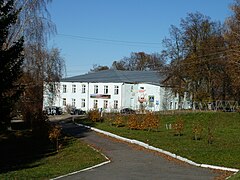
Former church used as a district administration and cultural center

Nikolai Church
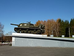
ISU-152 self-propelled gun as a World War II memorial

Village pond

View of the western part of the village


history
The village was first mentioned in 1734 in connection with the construction of a church under the name of Shchir - after the spelling of the river name (Russian Щир ); so it is probably much older. It belonged to the Ujesd Kromy , from 1778 part of the governorship of Oryol, from 1796 of the Oryol governorate . In 1861 the place became the seat of a Volost , already under its current name, derived from the original name Saskowo (Russian Саськово ) of the district on the right of the river. After the dissolution of the Ujesd on February 11, 1924, the village belonged to the Ujesd Orjol.
On July 30, 1928, Soskowo came to a newly formed Rajon with headquarters in the village of Verkhnyaya Bojowka 10 km northeast , which, however, was dissolved again in January 1931; its territory was attached to the Uritski rajon with headquarters in Naryschkino , a good 30 km northeast . After the formation of the Kursk Oblast on June 13, 1934, the Rajon, which was dissolved in 1931, was restored on January 18, 1935, now with its seat in Soskowo and named after it; the Oryol Oblast was only created in 1937 by spinning off from the Kursk Oblast, with the Rajon being preserved.
During World War II , Soskowo was occupied by the German Wehrmacht from October 2, 1941 to August 11, 1943 .
On February 1, 1963, the Rajon was again dissolved in favor of the Uritski rajon and restored on August 23, 1985.
Population development
| year | Residents |
|---|---|
| 1897 | 576 |
| 1939 | 1282 |
| 1959 | 576 |
| 1989 | 1759 |
| 2002 | 2122 |
| 2010 | 1794 |
Note: census data
traffic
Regional road 54K-17 runs from Soskowo in a north-easterly direction to the neighboring district center of Naryshkino on the federal highway R120 (Oryol - Bryansk - Smolensk ). Via the 54K-354, which runs to the southeast, there is a connection in the direction of Kromy on the M2 Crimean federal trunk road , which is about 30 km away on the Moscow - Tula - Oryol - Kursk - Belgorod - Kharkiv route and the nearest train station. Subordinate road connections exist to the south and north-west neighboring Rajon centers of Dmitrowsk and Schablykino .
Web links
Individual evidence
- ↑ a b Itogi Vserossijskoj perepisi naselenija 2010 goda. Tom 1. Čislennostʹ i razmeščenie naselenija (Results of the All-Russian Census 2010. Volume 1. Number and distribution of the population). Tables 5 , pp. 12-209; 11 , pp. 312–979 (download from the website of the Federal Service for State Statistics of the Russian Federation)
| Cities |
Bolchow R | Dmitrovsk R | Liwny S / R | Maloarchangelsk R | Mtsensk S / R | Nowosil R | Oryol S / R |
|
| Urban-type settlements |
Khomutovo R | Chotynez R | Dolgoje R | Glasunowka R | Kolpna R | Kromy R | Naryschkino R | Pokrovskoye R | Salegoschtsch R | Schablykino R | Smijowka R | Snamenka | Verkhovye R |
|
| Other Rajon centers |
Korsakovo | Krasnaya Zarya | Znamenskoye | Soskowo | Trosna |