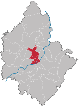
City center (Plauen)
|
City center City area of Plauen |
|
|---|---|
| Coordinates | 50 ° 29 ′ 0 ″ N , 12 ° 7 ′ 0 ″ E |
| surface | 2.90 km² |
| Residents | 12,443 (Dec. 31, 2003) |
| Population density | 4291 inhabitants / km² |
| Postcodes | 08523, 08525, 08527 |
| structure | 6 districts |
The city center is one of five urban areas in the city of Plauen in Saxony . It is divided into six districts.
The city area is traversed by the White Elster and the Syrabach . There is also the historic old town with the Altmarkt, the former pot market and the Vogtland Museum . Well-known buildings in the city area are the old and the new town hall , the Friedensbrücke (as the border to the west of the city ) as well as the Luther Church , the Johanniskirche , the rebuilt commander building of the Teutonic Order, the Malzhaus and the remains of the castle of the bailiffs.
Districts
| district | District number | District key | Postcodes | Area [m²] As of December 31, 2011 |
Remarks |
|---|---|---|---|---|---|
| Old town | 101 | 08523, 08527 | |||
| Station suburb | 102 | 08523, 08525, 08527 | |||
| Dobenau | 103 | 08523 | |||
| Neustadt | 104 | 08523, 08527 | |||
| Upper floodplain | 105 | 08523, 08527 | |||
| Schlossberg | 106 | 08523 |
Source: Official statistical report of the City of Plauen 2012
Individual evidence
- ↑ Official statistical report of the city of Plauen 2012. (PDF; 5,340 KB) Retrieved on February 28, 2013 .
Web links
- Dobenau in the Digital Historical Directory of Saxony


